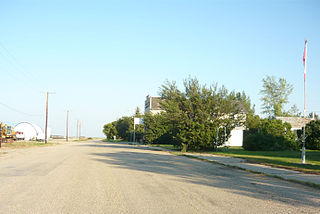
Aylesbury is a village in the Canadian province of Saskatchewan within the Rural Municipality of Craik No. 222 and Census Division No. 7. The village is approximately 60 km north of the City of Moose Jaw.

Assiniboia is a town in the Canadian province of Saskatchewan. It is located 110 km (68 mi) south-southwest of Moose Jaw beside Highway 2 and Highway 13.
Fife Lake is a hamlet located between Coronach and Rockglen within Rural Municipality of Poplar Valley No. 12 in south-central Saskatchewan, Canada near the border with the United States. Approximately 40 people inhabited the village of Fife Lake in 2006. It is about 11 kilometres (6.8 mi) east of Rockin Beach Park and Fife Lake.
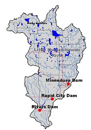
The Little Saskatchewan River is a river in western Manitoba. It originates in Riding Mountain National Park at Lake Audy and flows about 65 miles (105 km) south through the communities of Minnedosa and Rapid City. Its approximate length is 185 km. It joins the Assiniboine River about 6 miles (9.7 km) west of Brandon. The watershed has an area of 1,400 square miles (3,600 km2). The watershed includes numerous lakes and three man made reservoirs (Minnedosa Lake, Rapid City Reservoir and Lake Wahtopanah.
Bengough is a town surrounded by the rural municipality of Bengough No. 40, in the Canadian province of Saskatchewan. A southeastern Saskatchewan prairie town, Bengough is located east of Willow Bunch Lake on Highway 34 near Highway 705. The town is named Bengough after cartoonist John Wilson Bengough. Bengough also plays host to the Gateway Festival which showcases various musicians and several other events through the weekend, usually taking place in late July.

The Big Muddy Badlands are a series of badlands in southern Saskatchewan, Canada, and northern Montana, Unites States, in the Big Muddy Valley and along Big Muddy Creek. Big Muddy Valley is a cleft of erosion and sandstone that is 55 kilometres (34 mi) long, 3.2 kilometres (2.0 mi) wide, and 160 metres (520 ft) deep.
Minton is a village in the Canadian province of Saskatchewan within the Rural Municipality of Surprise Valley No. 9 and Census Division No. 2. It is on Highway 6 just north of its intersection with Highway 18, 19 km north of the Raymond-Regway Border Crossing on the Montana-Saskatchewan border. The village was named after Minton, Shropshire in England. The name was given by the Canadian Pacific Railway.

Meacham is a village in the Canadian province of Saskatchewan within the Rural Municipality of Colonsay No. 342 and Census Division No. 11. It is located 69 kilometres east of the City of Saskatoon on Highway 2.
Middle Lake is a village in the Canadian province of Saskatchewan within the Rural Municipality of Three Lakes No. 400 and Census Division No. 15. The village has a public K-12 school, a nursing home, and a regional park. It is adjacent to Lucien Lake and accessed from Highway 20. The surrounding area is largely agricultural.
Lisieux is an unincorporated community in the Rural Municipality of Willow Bunch No. 42, Saskatchewan, Canada. It was designated as an organized hamlet prior to 2018.
Tantallon is a village in the Canadian province of Saskatchewan within the Rural Municipality of Spy Hill No. 152 and Census Division No. 5. It is in the Qu'Appelle Valley along the Qu'Appelle River about 39 km east of Round Lake (Saskatchewan). The community celebrated its centennial in 2004.

Tuxford is a village in the Canadian province of Saskatchewan within the Rural Municipality of Marquis No. 191 and Census Division No. 7. Moose Jaw is 14 kilometres (8.7 mi) south and Buffalo Pound Lake is 16 kilometres (9.9 mi) north. Highway 2, Highway 42 and Highway 202 all intersect in the community. Highway 202 connects the community to Buffalo Pound Provincial Park 11 kilometres (6.8 mi) to the east.
Ceylon is a village in the Canadian province of Saskatchewan within the Rural Municipality of The Gap No. 39 and Census Division No. 2. It is located alongside Gibson Creek, which is a tributary of Long Creek. No shops or businesses other than the bar remain.
Weyakwin is a northern hamlet in the Canadian province of Saskatchewan. It is situated along Highway 2 on the south bank of Weyakwin River. The Weyakwin River flows from Weyakwin Lake east to Montreal Lake.
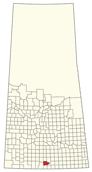
The Rural Municipality of Willow Bunch No. 42 is a rural municipality (RM) in the Canadian province of Saskatchewan within Census Division No. 3 and SARM Division No. 2. It is located in the south central portion of the province.

The Rural Municipality of Last Mountain Valley No. 250 is a rural municipality (RM) in the Canadian province of Saskatchewan within Census Division No. 11 and SARM Division No. 5.

Willows is an unincorporated community in Lake of the Rivers Rural Municipality No. 72, Saskatchewan, Canada. It previously held the status of a village until January 1, 1950. The name is a contraction of William Gibson Lowes, owner of the first store.

The Buffalo River Dene Nation is a Dene First Nations band government in Saskatchewan, Canada. The band's main community, Dillon, is located on the western shore of Peter Pond Lake at the mouth of the Dillon River, and is accessed by Highway 925 from Highway 155.
Glasnevin is an unincorporated community in Key West Rural Municipality No. 70 in the province of Saskatchewan, Canada. Located on highway 13, it is approximately 10 km west of Ogema.
Fife Lake is a fresh water prairie lake in the Canadian province of Saskatchewan. It is in the south-central part of the province at the eastern end of the Wood Mountain Hills. The entire lake and its shoreline is designated an Important Bird Area (IBA) of Canada to protect the nationally endangered piping plover. While there are no communities along the lake's shore, there is a park and campground at the southern end. Nearby communities include Fife Lake, Rockglen, and Lisieux. Access is from Highway 18.

