Lisieux is an unincorporated community in the Rural Municipality of Willow Bunch No. 42, Saskatchewan, Canada. It was designated as an organized hamlet prior to 2018.
Lisieux is an unincorporated community in the Rural Municipality of Willow Bunch No. 42, Saskatchewan, Canada. It was designated as an organized hamlet prior to 2018.
The place was originally named Joeville, after Joseph-Hermenegilde Préfontaine, an early homesteader. It was given its present name in 1926 to honour the recently canonized Saint Thérèse of Lisieux. There was a post office at Lisieux from 1921 to 1991. [1] Lisieux relinquished its organized hamlet designation on December 31, 2017. [2]
In the 2021 Census of Population conducted by Statistics Canada, Lisieux had a population of 10 living in 6 of its 9 total private dwellings, a change of 0% from its 2016 population of 10. With a land area of 0.21 km2 (0.081 sq mi), it had a population density of 47.6/km2 (123.3/sq mi) in 2021. [3]
Minburn is a hamlet in central, Alberta, Canada within the County of Minburn No. 27. It is located on the Yellowhead Highway and the Canadian National Railway, approximately 37 km (23 mi) west of the Town of Vermilion and 143 km (89 mi) east of the City of Edmonton.
Fife Lake is a hamlet located between Coronach and Rockglen within Rural Municipality of Poplar Valley No. 12 in south-central Saskatchewan, Canada near the border with the United States. Approximately 40 people inhabited the village of Fife Lake in 2006. It is about 11 kilometres (6.8 mi) east of Rockin Beach Park and Fife Lake.

Division No. 3 is one of eighteen census divisions in the province of Saskatchewan, Canada, as defined by Statistics Canada. It is located in the south-southwestern part of the province, adjacent to the border with Montana, United States. The most populous community in this division is Assiniboia.

The Rural Municipality of Meadow Lake No. 588 is a rural municipality (RM) in the Canadian province of Saskatchewan within Census Division No. 17 and SARM Division No. 6.
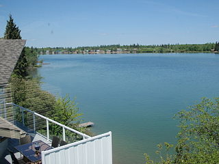
Crystal Lake is an organized hamlet within the Rural Municipality (RM) of Keys No. 303 in the Canadian province of Saskatchewan. It is also recognized as part of a designated place by Statistics Canada. The organized hamlet is on the majority of the shores of Crystal Lake, 1.0 km (0.62 mi) west of Highway 9 and approximately 70 km (43 mi) north of the City of Yorkton. The second part of the designated place is on the balance of the shores of Crystal Lake within the adjacent RM of Buchanan No. 304.
Guernsey is an organized hamlet within the Rural Municipality of Usborne No. 310 in the Canadian province of Saskatchewan. It previously held village status until it dissolved in 2005.
Kylemore is an unincorporated community in the Rural Municipality of Sasman No. 336, Saskatchewan, Canada. Listed as a designated place by Statistics Canada, the community had a population of 0 in the Canada 2016 Census. It was designated as an organized hamlet prior to 2018. The community is located 12 km east of Wadena, and approximately 250 km east of Saskatoon.
Ormiston is an organized hamlet in Excel Rural Municipality No. 71, Saskatchewan, Canada. The population was 25 at the 2011 Census. It is located in the south-central portion of the province, south of the city of Moose Jaw.
Radway is a hamlet in central Alberta, Canada within Thorhild County. It is located 0.75 kilometres (0.47 mi) southeast of Highway 28, approximately 42 kilometres (26 mi) northeast of Fort Saskatchewan and 70 kilometres (43 mi) northeast of Edmonton.

The Rural Municipality of Lake Alma No. 8 is a rural municipality (RM) in the Canadian province of Saskatchewan within Census Division No. 2 and SARM Division No. 2. Located in the southeast portion of the province, it is adjacent to the United States border, neighbouring Sheridan County in Montana and Divide County in North Dakota.
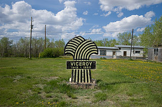
Viceroy is a hamlet in Excel Rural Municipality No. 71, Saskatchewan, Canada. The population was 25 at the 2011 Census. The hamlet previously held the status of a village until May 10, 2002. Viceroy is located 7 km south of the historic Red Coat Trail on Highway 624 north of Willow Bunch Lake adjacent to Big Muddy Valley.
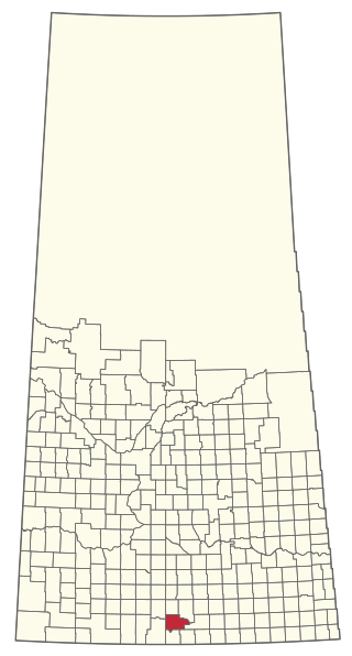
The Rural Municipality of Willow Bunch No. 42 is a rural municipality (RM) in the Canadian province of Saskatchewan within Census Division No. 3 and SARM Division No. 2. It is located in the south central portion of the province.

The Rural Municipality of Willow Creek No. 458 is a rural municipality (RM) in the Canadian province of Saskatchewan within Census Division No. 14 and SARM Division No. 4.

The Rural Municipality of Hazel Dell No. 335 is a rural municipality (RM) in the Canadian province of Saskatchewan within Census Division No. 9 and SARM Division No. 4.
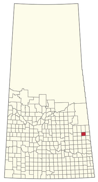
The Rural Municipality of Keys No. 303 is a rural municipality (RM) in the Canadian province of Saskatchewan within Census Division No. 9 and SARM Division No. 4.
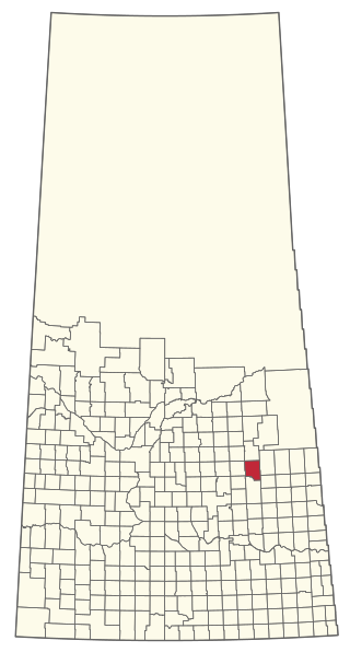
The Rural Municipality of Sasman No. 336 is a rural municipality (RM) in the Canadian province of Saskatchewan within Census Division No. 10 and SARM Division No. 4.

St. Victor, or Saint Victor, is a Fransaskois community in the Rural Municipality of Willow Bunch No. 42. In 2006, it had a population of 43 people. It previously held the status of village until February 26, 2003. St. Victor is located 37 km south of the town of Assiniboia 10 km east of Highway 2. St. Victor Petroglyphs Provincial Park is two kilometres south of the community.
Lockwood is a former village in the Canadian province of Saskatchewan. It was dissolved in 2002; its population is now counted as part of the rural municipality of Usborne. Lockwood is located on Highway 20 15 km north of the Town of Nokomis.
Coordinates: 49°16′46″N105°58′32″W / 49.27944°N 105.97556°W