
Midale, Saskatchewan is a town in the rural municipality of Cymri No. 36, in the Canadian province of Saskatchewan. It is located on Highway 39, midway between the cities of Weyburn and Estevan. The population of Midale is 562. It is 160 kilometres southeast of Regina, Saskatchewan.

Choiceland is a town located in Saskatchewan, Canada. Choiceland is located an hour or so from Prince Albert, a larger Saskatchewan city.

Rocanville is a community in Saskatchewan, Canada, and home to the largest oil can in the world. It is home of the Potash Corporation of Saskatchewan (PCS) potash mine which recently announced a $1.6 billion expansion. Rocanville is also the home of the Symons Oiler factory which produced over 1 million oil cans during the Second World War. The town erected the giant oil can to commemorate the factory.
Piapot is a hamlet within the Rural Municipality of Piapot No. 110, Saskatchewan, Canada. Listed as a designated place by Statistics Canada, the hamlet had a population of 50 in the Canada 2016 Census.
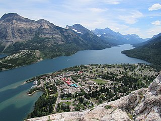
Waterton Park, commonly referred to as Waterton, is a hamlet in southwestern Alberta, Canada within Improvement District No. 4 Waterton.
Ardill is a hamlet in Lake Johnston Rural Municipality No. 102, Saskatchewan, Canada. Listed as a designated place by Statistics Canada, the hamlet had a listed population of 0 in the Canada 2006 Census.
Beaver Creek is a hamlet in the Rural Municipality of Dundurn No. 314, Saskatchewan, Canada. Listed as a designated place by Statistics Canada, the hamlet had a population of 107 in the Canada 2016 Census.
Courval is an unincorporated community in the Rural Municipality of Rodgers No. 133 in the Canadian province of Saskatchewan. Recognized as a designated place by Statistics Canada, Courval had a population of 5 in the Canada 2006 Census.
Darlings Beach is a hamlet in Rural Municipality of Lac Pelletier No. 107, Saskatchewan, Canada. Listed as a designated place by Statistics Canada, the hamlet had a population of 0 in the Canada 2011 Census. The hamlet is located on the east shores of the Lac Pelletier, within the Lac Pelletier Regional Park. It is approximately 48.1 kilometres (29.9 mi) south and west of Swift Current, 4.4 km south of Highway 343.
Hendon is a hamlet in the Rural Municipality of Lakeview No. 337, Saskatchewan, Canada. Listed as a designated place by Statistics Canada, the hamlet had a population of 20 in the Canada 2016 Census.

Kronau is a hamlet in the Canadian province of Saskatchewan located 28 km south east of Regina on Highway 33 in the R.M. of Lajord No. 128, Saskatchewan. Listed as a designated place by Statistics Canada, the hamlet had a population of 209 in the Canada 2006 Census.
Kuroki is a hamlet in the Rural Municipality of Sasman No. 336, Saskatchewan, Canada. Listed as a designated place by Statistics Canada, the hamlet had a population of 50 in the Canada 2016 Census. The community is named after the Japanese general Kuroki Tamemoto.
Lisieux is an unincorporated community in the Rural Municipality of Willow Bunch No. 42, Saskatchewan, Canada. Listed as a designated place by Statistics Canada, the community had a population of 15 in the Canada 2006 Census. It was designated as an organized hamlet prior to 2018.
Ottman-Murray Beach is a hamlet in the Canadian province of Saskatchewan. Listed as a designated place by Statistics Canada, the hamlet had a population of 15 in the Canada 2016 Census.
Wishart is a hamlet in Emerald Rural Municipality No. 277 in the Canadian province of Saskatchewan. It is listed as a designated place by Statistics Canada. The hamlet had a population of 95 in the Canada 2006 Census. It previously held the status of village until January 1, 2002. The hamlet is located 32 km south west of the village of Elfros at the intersection of highway 639 and highway 743.

Wymark is a hamlet in Swift Current Rural Municipality No. 137, Saskatchewan, Canada. Listed as a designated place by Statistics Canada, the hamlet had a population of 144 in the Canada 2006 Census. The hamlet is located on Highway 628 about 2 km north of Highway 363, about 15 km south of Swift Current.
Vantage is a hamlet in Sutton Rural Municipality No. 103, Saskatchewan, Canada. Listed as a designated place by Statistics Canada, the hamlet had a reported population of zero in the Canada 2006 Census.
Quinton is a village in the Canadian province of Saskatchewan within the Rural Municipality of Mount Hope No. 279 and Census Division No. 10. The village is located on Highway 15 between the Town of Raymore and the Village of Punnichy. It is near the administrative office of the Kawacatoose First Nations.
Spring Valley is a hamlet in Terrell Rural Municipality No. 101 in the province of Saskatchewan, Canada. Located at the end of highway 715, and approximately 62 km south of the city of Moose Jaw.
Colgate is a hamlet in Lomond Rural Municipality No. 37, Saskatchewan, Canada. The community had a population of 34 in 2017. It previously held the status of village until May 16, 2000. The hamlet is located 34 km south of the City of Weyburn 4 km west of highway 35.

