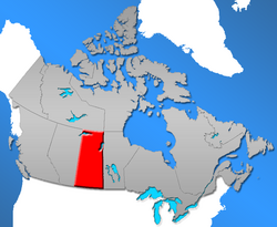
Location of Saskatchewan in Canada A topographic map of Saskatchewan, showing cities, towns, rural municipality borders, and natural features Communities in the province of Saskatchewan , Canada, include incorporated municipalities , unincorporated communities and First Nations communities.
Types of incorporated municipalities include urban municipalities, rural municipalities and northern municipalities. Urban municipalities are further classified into four sub-types – cities , towns , villages and resort villages. Northern municipalities, which are located in the Northern Saskatchewan Administration District (NSAD), are further classified into three sub-types – northern towns, northern villages and northern hamlets. Rural municipalities are not classified into sub-types. [ 1]
Types of unincorporated communities include hamlets and organized hamlets within rural municipalities and northern settlements within the NSAD. [ 1]
The administration of rural municipalities, towns, villages, resort villages, organized hamlets and hamlets is regulated by The Municipalities Act , [ 2] while the administration of cities is regulated by The Cities Act . [ 3] Administration of northern towns, northern villages, northern hamlets and northern settlements (those within the NSAD) [ 4] is regulated by The Northern Municipalities Act . [ 5]
In the 2021 Census , Saskatchewan's communities combined for a total provincial population of 1,132,505. [ 6]
Municipalities Saskatchewan presently has 786 municipalities of various types (urban, rural and northern municipalities) and sub-types (cities, towns, villages, resort villages, northern towns, northern villages and northern hamlets). [ 1]
Urban municipalities Distribution of Saskatchewan's 16 cities, 146 towns, 264 villages and 40 resort villages Saskatchewan has 466 urban municipalities, which includes the sub-types of cities, towns, villages and resort villages. [ 1]
Cities In Saskatchewan, towns must have a population above 5,000 in order to be granted city status . [ 3] A city does not automatically revert to town status if the population drops below 5,000; this only occurs if the city council requests it, the majority of electors vote to revert to town status or the appropriate provincial minister is of the opinion that the reversion to town status is in the public interest. [ 3] The city of Melville retains city status as of 2010 despite dropping below 5,000 population in the 1990s.
Saskatchewan has 16 cities, [ 1] including Lloydminster and not including Flin Flon .
Cities of Saskatchewan Name Rural municipality [ 7] Incorporation date (city) [ 8] Population (2021) [ 9] Population (2016) [ 9] Change (%) [ 9] Land area (km2 ) [ 9] Land area (sq mi) Population density (/km2 ) [ 9] Population density (/sq mi) Estevan Estevan No. 5 March 1, 1957 10,851 11,483 −5.5% 18.30 7.07 593.0 1,536 Flin Flon (part) [ SK 1] — — 159 [ SK 2] 203 −21.7% 2.01 [ SK 3] 0.78 79.1 205 Humboldt Humboldt No. 370 November 7, 2000 6,033 5,869 +2.8% 13.30 5.14 453.6 1,175 Lloydminster (part) [ SK 4] Britannia No. 502 Wilton No. 472 January 1, 1958 11,843 [ SK 5] 11,765 +0.7% 18.06 [ SK 6] 6.97 655.8 1,699 Martensville [ SK 7] Corman Park No. 344 November 3, 2009 10,549 9,655 +9.3% 13.56 5.24 777.9 2,015 Meadow Lake Meadow Lake No. 588 November 9, 2009 5,322 5,344 −0.4% 12.37 4.78 430.2 1,114 Melfort Star City No. 428 September 2, 1980 5,955 5,992 −0.6% 14.73 5.69 404.3 1,047 Melville [ SK 8] Cana No. 214 August 1, 1960 4,493 4,562 −1.5% 14.78 5.71 304.0 787 Moose Jaw Moose Jaw No. 161 November 20, 1903 33,665 33,910 −0.7% 65.81 25.41 511.5 1,325 North Battleford North Battleford No. 437 May 1, 1913 13,836 14,315 −3.3% 33.55 12.95 412.4 1,068 Prince Albert Prince Albert No. 461 October 8, 1904 37,756 35,926 +5.1% 67.17 25.93 562.1 1,456 Regina [ SK 9] Sherwood No. 159 June 19, 1903 226,404 215,106 +5.3% 178.81 69.04 1,266.2 3,279 Saskatoon [ SK 10] Corman Park No. 344 May 26, 1906 266,141 247,201 +7.7% 226.56 87.48 1,174.7 3,042 Swift Current Swift Current No. 137 January 15, 1914 16,750 16,604 +0.9% 29.30 11.31 571.7 1,481 Warman [ SK 11] Corman Park No. 344 October 27, 2012 12,419 11,020 +12.7% 13.10 5.06 948.0 2,455 Weyburn Weyburn No. 67 September 1, 1913 11,019 10,870 +1.4% 19.03 7.35 579.0 1,500 Yorkton Orkney No. 244 February 1, 1928 16,280 16,343 −0.4% 36.19 13.97 449.8 1,165 Total cities — — 689,475 656,168 +5.1% 776.63 299.86 887.8 2,299
Towns In Saskatchewan, towns are formed from villages or resort villages with a population of at least 500 people. [ 2] The council of the village or resort village must request the change to town status. When a town's population exceeds 5,000 people, the council may request a change to city status, but the change in incorporation level is not mandatory. Towns with shrinking populations are allowed to retain town status even if the number of residents falls below the 500 limit. For example, the towns of Fleming , Francis , and Scott have populations that have dropped under 500 people and are still qualified under town status. Towns with populations below the limit may, however, revert to village or resort village status if the town council requests it.
Saskatchewan has 146 towns. [ 1]
Towns of Saskatchewan Name Rural Population (2021)[ citation needed ]
Population (2016)[ citation needed ]
Population [ 10] Population [ 10] Change [ 10] Land2 ) [ 10] Population2 ) [ 10] Aberdeen Aberdeen No. 373 716 662 599 527 13.7 1.95 307 Alameda Moose Creek No. 33 345 369 342 308 11 2.55 133.9 Allan Blucher No. 343 625 644 648 631 2.7 1.78 363.2 Arborfield Arborfield No. 456 285 312 326 329 −0.9 0.88 370.5 Arcola Brock No. 64 636 657 649 509 27.5 3.39 191.5 Asquith Vanscoy No. 345 624 639 603 576 4.7 1.23 491.4 Assiniboia Lake of the Rivers No. 72 2,333 2,424 2,418 2,305 4.9 3.78 639.8 Balcarres Abernethy No. 186 616 587 617 598 3.2 1.57 392.9 Balgonie Edenwold No. 158 1,756 1,765 1,625 1,384 17.4 3.15 515.8 Battleford Battle River No. 438 4,400 4,429 4,065 3,685 10.3 23.33 174.2 Bengough Bengough No. 40 332 332 313 337 −7.1 1.07 292 Bienfait Coalfields No. 4 668 762 780 748 4.3 3.09 252.4 Big River Big River No. 555 666 700 639 728 −12.2 2.51 255 Biggar Biggar No. 347 2,133 2,226 2,161 2,033 6.3 15.75 137.2 Birch Hills Birch Hills No. 460 1,066 1,033 1,064 935 13.8 2.27 468.4 Blaine Lake Blaine Lake No. 434 509 499 510 472 8.1 1.95 261.6 Bredenbury Saltcoats No. 213 386 372 364 329 10.6 4.8 75.8 Broadview Elcapo No. 154 541 552 574 611 −6.1 2.45 233.8 Bruno Bayne No. 371 604 611 574 495 16 0.95 606.1 Burstall Deer Forks No. 232 302 278 301 315 −4.4 1.11 270 Cabri Riverside No. 168 413 390 399 439 −9.1 1.33 298.9 Canora Good Lake No. 274 2,092 2,024 2,219 2,013 10.2 7.31 303.7 Carlyle Moose Mountain No. 63 1,524 1,508 1,441 1,257 14.6 3.19 451.1 Carnduff Mount Pleasant No. 2 1,150 1,099 1,126 1,012 11.3 2.26 497.3 Carrot River Moose Range No. 486 946 973 1,000 941 6.3 1.42 706.4 Central Butte Enfield No. 194 416 372 365 372 −1.9 2.24 163.2 Choiceland Torch River No. 488 342 359 381 346 10.1 1.12 340.8 Churchbridge Churchbridge No. 211 866 896 743 704 5.5 2.76 269.2 Colonsay Colonsay No. 342 446 451 475 425 11.8 2.46 193.1 Coronach Hart Butte No. 11 612 643 711 770 −7.7 2.33 304.9 Craik Craik No. 222 405 392 453 408 11 3.02 150 Cudworth Hoodoo No. 401 772 814 770 738 4.3 2.21 348.7 Cupar Cupar No. 218 598 564 579 566 2.3 0.8 726.7 Cut Knife Cut Knife No. 439 547 573 517 532 −2.8 1.99 259.3 Dalmeny Corman Park No. 344 1,766 1,826 1,702 1,560 9.1 2.27 751 Davidson Arm River No. 252 1,044 1,048 1,025 958 7 4.49 228.4 Delisle Vanscoy No. 345 1,024 1,038 975 898 8.6 2.49 391.3 Duck Lake Duck Lake No. 463 579 569 577 605 −4.6 2.73 211.6 Dundurn Dundurn No. 314 675 611 693 647 7.1 1.37 505.3 Eastend White Valley No. 49 607 503 527 471 11.9 2.71 194.7 Eatonia Chesterfield No. 261 498 524 508 449 13.1 1.68 301.6 Elrose Monet No. 257 470 496 477 453 5.3 2.76 172.8 Esterhazy Fertile Belt No. 183 2,345 2,502 2,472 2,336 5.8 4.75 520.9 Eston Snipe Lake No. 259 972 1061 1,031 971 6.2 2.72 379.3 Fleming Moosomin No. 121 70 84 83 75 10.7 2.17 38.3 Foam Lake Foam Lake No. 276 1,183 1,141 1,148 1,123 2.2 6.06 189.4 Fort Qu'Appelle North Qu'Appelle No. 187 1,972 2,042 2,034 1,919 6 5.28 385 Francis Francis No. 127 182 217 176 148 18.9 0.59 297.4 Govan Last Mountain Valley No. 250 200 194 216 232 −6.9 1.35 159.7 Grand Coulee Sherwood No. 159 606 649 571 435 31.3 0.33 1,707.5 Gravelbourg Gravelbourg No. 104 986 1,083 1,116 1,089 2.5 3.23 346 Grenfell Elcapo No. 154 1,059 1.099 1,049 947 10.8 3.17 331.2 Gull Lake Gull Lake No. 139 908 1,046 989 965 2.5 2.5 395.6 Hafford Redberry No. 435 414 407 397 360 10.3 0.8 496.8 Hague Rosthern No. 403 889 874 878 707 24.2 1.08 815.5 Hanley Rosedale No. 283 540 511 522 464 12.5 2.65 196.8 Hepburn Laird No. 404 784 688 562 530 6 1.02 548.4 Herbert Morse No. 165 770 856 759 742 2.3 3.78 200.7 Hudson Bay Hudson Bay No. 394 1,403 1,436 1,900 [ 11] 1,646 −8.6 17.35 86.7 Imperial Big Arm No. 251 372 360 349 321 8.7 1.23 283.5 Indian Head Indian Head No. 156 1,902 1,910 1,815 1,634 11.1 3.17 572.1 Ituna Ituna Bon Accord No. 246 726 701 711 622 14.3 1.56 455.5 Kamsack Cote No. 271 1,779 1,898 1,825 1,713 6.5 5.85 311.8 Kelvington Kelvington No. 366 827 834 890 [ 11] 866 2.8 3.89 228.8 Kerrobert Progress No. 351 970 1,026 1,061 1,001 6 7.49 141.7 Kindersley Kindersley No. 290 4,567 4,597 4,678 4,412 6 12.55 372.8 Kinistino Kinistino No. 459 671 654 743 643 15.6 0.98 758.8 Kipling Kingsley No. 124 1,076 1,074 1,051 973 8 2.15 487.9 Kyle Lacadena No. 228 413 449 437 423 3.3 1.14 383.1 Lafleche Wood River No. 74 373 382 406 370 9.7 1.51 269.7 Lampman Browning No. 34 676 675 713 634 12.5 2.23 319.9 Langenburg Langenburg No. 181 1,228 1,165 1,148 1,048 9.5 3.46 332.2 Langham Corman Park No. 344 1,518 1,496 1,290 1,120 15.2 3.98 324.4 Lanigan Usborne No. 310 1,433 1,377 1,390 1,233 12.7 8.34 166.8 Lashburn Manitou Lake No. 442 870 983 967 914 5.8 3.11 310.5 Leader Happyland No. 231 881 863 821 881 −6.8 1.71 481.2 Lemberg Abernethy No. 186 266 313 274 255 7.5 2.67 102.7 Leroy Leroy No. 339 510 450 427 412 3.6 1.06 402.1 Lumsden Lumsden No. 189 1,800 1,824 1,631 1,523 7.1 4.06 402 Luseland Progress No. 351 559 623 566 571 −0.9 1.53 369.6 Macklin Eye Hill No. 382 1,247 1,374 1,415 1,290 9.7 3.14 450.7 Maidstone Eldon No. 471 1,209 1,185 1,156 1,037 11.5 4.56 253.5 Maple Creek Maple Creek No. 111 2,176 2,084 2,176 2,198 −1 4.42 492.1 Marshall Wilton No. 472 522 591 594 [ 11] 608 −2.3 1.01 588.1 Midale Cymri No. 36 510 604 562 462 21.6 1.53 368.5 Milestone Brock No. 64 682 699 618 562 10 2.17 284.4 Moosomin Moosomin No. 121 2,657 2,743 2,485 2,262 9.9 7.59 327.5 Morse Morse No. 165 216 242 240 236 1.7 1.45 165.7 Mossbank Lake Johnston No. 102 368 360 327 330 −0.9 1.75 186.8 Naicam Pleasantdale No. 398 651 661 686 690 −0.6 1.69 405.5 Nipawin Nipawin No. 487 4,570 4,401 4,265 4,076 4.6 8.71 489.4 Nokomis Wreford No. 280 414 404 397 404 −1.7 2.61 152.3 Norquay Clayton No. 333 240 434 435 412 5.6 1.69 258 Ogema Key West No. 70 383 403 368 304 21.1 1.43 257.6 Osler Corman Park No. 344 1,251 1,237 1,088 926 17.5 1.55 700.6 Outlook Rudy No. 284 2,336 2,279 2,204 1,938 13.7 7.83 281.3 Oxbow Enniskillen No. 3 1,286 1,328 1,285 1,139 12.8 3.13 410 Pense Pense No. 160 603 587 532 507 4.9 1.32 402.6 Pilot Butte Edenwold No. 158 2,638 2,137 1,848 1,872 −1.3 5.05 365.6 Ponteix Auvergne No. 76 577 563 605 531 13.9 1.09 556 Porcupine Plain Porcupine No. 395 817 862 855 783 9.2 2.27 377.2 Preeceville Preeceville No. 334 1,062 1,125 1,070 1,050 1.9 3.06 350.2 Qu'Appelle South Qu'Appelle No. 157 625 639 668 624 7.1 4.22 158.1 Radisson Great Bend No. 405 416 514 505 421 20 2.07 243.6 Radville Laurier No. 38 778 804 860 793 8.4 2.16 398.6 Raymore Moose Range No. 486 507 575 568 581 −2.2 2.75 206.8 Redvers Antler No. 61 1,008 1,042 975 878 11 2.96 329 Regina Beach Lumsden No. 189 1,292 1,145 1,081 1,210 −10.7 3.88 278.5 Rocanville Rocanville No. 151 889 863 857 869 −1.4 2.43 352.3 Rockglen Poplar Valley No. 12 399 441 400 366 9.3 2.85 140.4 Rose Valley Ponass Lake No. 367 256 282 296 338 −12.4 1.12 263.4 Rosetown St. Andrews No. 287 2,507 2,451 2,317 2,277 1.8 12.14 190.8 Rosthern Rosthern No. 403 1,602 1,688 1,572 1,382 13.7 4.31 365 Rouleau Redburn No. 130 505 540 453 400 13.3 1.61 282.2 Saltcoats Saltcoats No. 213 473 484 474 467 1.5 1.35 352.2 Scott Tramping Lake No. 380 74 73 75 91 −17.6 4.39 17.1 Shaunavon Grassy Creek No. 78 1,784 1,714 1,756 1,691 3.8 5.1 344.2 Shellbrook Shellbrook No. 493 1,510 1,444 1,433 1,230 16.5 3.67 390.3 Sintaluta Indian Head No. 156 124 119 120 98 22.4 2.7 44.5 Southey Cupar No. 218 832 804 778 711 9.4 1.56 499.8 Spiritwood Spiritwood No. 496 966 913 916 911 0.5 2.95 310 Springside Orkney No. 244 478 502 534 513 4.1 0.68 791 St. Brieux Lake Lenore No. 399 638 667 590 492 19.9 2.55 231.4 St. Walburg Frenchman Butte No. 501 591 689 716 672 6.5 2.12 338 Star City Star City No. 428 374 387 460 428 7.5 0.7 661.1 Stoughton Tecumseh No. 65 652 649 694 653 6.3 3.41 203.2 Strasbourg McKillop No. 220 788 800 752 732 2.7 5.7 132 Sturgis Preeceville No. 334 646 644 620 575 7.8 3.41 181.6 Tisdale Tisdale No. 427 2,962 3,235 3,180 3,000 6 6.47 491.5 Turtleford Mervin No. 499 503 496 525 461 13.9 1.69 311.6 Unity Round Valley No. 410 2,496 2,573 2,389 2,147 11.3 9.77 244.6 Vonda Grant No. 372 384 384 353 322 9.6 2.86 123.6 Wadena Lakeview No. 337 1,269 1,288 1,306 1,315 −0.7 2.91 449.5 Wakaw Fish Creek No. 402 978 922 985 864 14 3.12 315.9 Waldheim Laird No. 404 1,237 1,213 1,035 868 19.2 1.97 525.5 Wapella Martin No. 122 278 326 333 311 7.1 2.57 129.8 Watrous Morris No. 312 1,842 1,900 1,857 1,743 6.5 11.17 166.2 Watson Lakeside No. 338 707 697 777 719 8.1 2.83 274.7 Wawota Wawken No. 93 555 543 560 522 7.3 1.24 451 White City Edenwold No. 158 3,702 3,099 1,894 1,113 70.2 6 315.6 Whitewood Willowdale No. 153 944 862 950 869 9.3 3.04 312 Wilkie Tramping Lake No. 380 1,195 1,219 1,301 1,222 6.5 9.48 137.3 Willow Bunch Willow Bunch No. 42 299 272 286 297 −3.7 0.84 339.2 Wolseley Wolseley No. 155 852 854 864 782 10.5 5.93 145.6 Wynyard Big Quill No. 308 1,724 1,798 1,767 1,744 1.3 5.29 334.1 Yellow Grass Scott No. 98 483 478 440 371 18.6 2.68 164.1 Zealandia St. Andrews No. 287 75 80 80 90 −11.1 1.38 57.9 Total towns 137,725 127,795 7.8 473.50 290.9
Villages The people of an organized hamlet may request that the hamlet be incorporated as a village or resort village. In order to qualify, the hamlet must have been an organized hamlet for at least 3 years, have a population of at least 100 in the most recent census, and contain at least 50 separate dwelling units or business premises. [ 2]
Saskatchewan has 260 villages. [ 1]
Villages of Saskatchewan Name Incorporation [ 12] Rural [ 13] Population [ 14] Population [ 14] Change [ 14] Land2 ) [ 14] Population2 ) [ 14] Abbey September 2, 1913 Miry Creek No. 229 142 115 +23.5% 0.77 2 Abernethy July 26, 1904 Abernethy No. 186 204 196 +4.1% 1.03 2 Albertville January 1, 1986 Wise Creek No. 77 86 140 −38.6% 1.12 2 Alida February 19, 1926 Reciprocity No. 32 120 131 −8.4% 0.37 2 Alvena July 1, 1936 Fish Creek No. 402 60 55 +9.1% 0.43 2 Annaheim April 1, 1977 St. Peter No. 369 210 219 −4.1% 0.78 2 Archerwill January 1, 1947 Barrier Valley No. 397 166 200 −17.0% 0.83 2 Arran September 21, 1916 Livingston No. 331 25 40 −37.5% 0.69 2 Atwater August 12, 1910 Fertile Belt No. 183 30 31 −3.2% 1.79 2 Avonlea February 10, 1912 Elmsthorpe No. 100 393 398 −1.3% 0.96 2 Aylesbury March 31, 1910 Craik No. 222 40 42 −4.8% 1.28 2 Aylsham August 4, 1947 Nipawin No. 487 65 71 −8.5% 0.48 2 Bangor June 8, 1911 Fertile Belt No. 183 38 46 −17.4% 1.65 2 Beatty March 31, 1921 Flett's Springs No. 429 60 63 −4.8% 0.82 2 Beechy May 11, 1925 Victory No. 226 228 239 −4.6% 1.06 2 Belle Plaine August 12, 1910 Pense No. 160 85 66 +28.8% 1.34 2 Bethune August 2, 1912 Dufferin No. 190 399 405 −1.5% 2.38 2 Bjorkdale April 1, 1968 Bjorkdale No. 426 201 199 +1.0% 1.39 2 Bladworth July 27, 1906 McCraney No. 282 65 60 +8.3% 0.84 2 Borden July 19, 1907 Great Bend No. 405 287 245 +17.1% 0.76 2 Bracken January 4, 1926 Lone Tree No. 18 20 30 −33.3% 0.6 2 Bradwell December 26, 1912 Blucher No. 343 166 230 −27.8% 0.42 2 Briercrest April 17, 1912 Redburn No. 130 159 111 +43.2% 0.62 2 Brock July 7, 1910 Kindersley No. 290 142 127 +11.8% 0.74 2 Broderick September 13, 1909 Rudy No. 284 85 71 +19.7% 0.91 2 Brownlee December 29, 1908 Eyebrow No. 193 55 50 +10.0% 2.42 2 Buchanan June 11, 1907 Buchanan No. 304 218 225 −3.1% 1.29 2 Buena Vista November 18, 1983 Lumsden No. 189 612 524 +16.8% 3.61 2 Bulyea March 9, 1909 McKillop No. 220 113 102 +10.8% 1.28 2 Cadillac July 2, 1914 Wise Creek No. 77 92 78 +17.9% 1.05 2 Calder January 18, 1911 Calder No. 241 90 97 −7.2% 0.75 2 Canwood July 18, 1916 Canwood No. 494 332 348 −4.6% 2.56 2 Carievale March 14, 1903 Argyle No. 1 240 236 +1.7% 0.88 2 Caronport January 1, 1988 Caron No. 162 994 1,068 −6.9% 1.9 2 Ceylon September 26, 1911 The Gap No. 39 111 99 +12.1% 0.75 2 Chamberlain January 31, 1911 Sarnia No. 221 90 88 +2.3% 0.7 2 Chaplin October 8, 1912 Chaplin No. 164 229 218 +5.0% 1.26 2 Christopher Lake March 1, 1985 Lakeland No. 521 289 281 +2.8% 4.56 2 Clavet July 1, 1978 Blucher No. 343 410 386 +6.2% 0.84 2 Climax December 11, 1923 Lone Tree No. 18 195 182 +7.1% 1 2 Coderre August 26, 1925 Rodgers No. 133 30 30 0.85 2 Codette March 9, 1929 Nipawin No. 487 198 205 −3.4% 0.37 2 Coleville July 1, 1953 Oakdale No. 320 305 311 −1.9% 1.87 2 Conquest October 24, 1911 Fertile Valley No. 285 160 176 −9.1% 1 2 Consul June 12, 1917 Reno No. 51 73 84 −13.1% 0.65 2 Craven April 11, 1905 Longlaketon No. 219 214 234 −8.5% 1.21 2 Creelman April 6, 1906 Fillmore No. 96 113 115 −1.7% 1.14 2 Debden June 7, 1922 Canwood No. 494 337 358 −5.9% 1.39 2 Denholm June 25, 1912 Mayfield No. 406 88 76 +15.8% 0.33 2 Denzil May 3, 1911 Eye Hill No. 382 143 135 +5.9% 0.55 2 Dilke December 30, 1912 Sarnia No. 221 98 77 +27.3% 1.28 2 Dinsmore November 3, 1913 Milden No. 286 289 318 −9.1% 2.59 2 Disley June 24, 1907 Lumsden No. 189 67 75 −10.7% 0.65 2 Dodsland August 23, 1913 Winslow No. 319 215 212 +1.4% 2.93 2 Dorintosh January 1, 1989 Meadow Lake No. 588 134 147 −8.8% 0.88 2 Drake September 19, 1910 Usborne No. 310 197 202 −2.5% 0.72 2 Drinkwater June 7, 1904 Redburn No. 130 70 65 +7.7% 2.64 2 Dubuc May 29, 1905 Grayson No. 184 61 70 −12.9% 0.63 2 Duff May 28, 1920 Stanley No. 215 30 30 0.22 2 Duval December 21, 1910 Last Mountain Valley No. 250 83 97 −14.4% 0.75 2 Dysart April 6, 1909 Lipton No. 217 200 218 −8.3% 1.19 2 Earl Grey July 27, 1906 Longlaketon No. 219 246 239 +2.9% 1.31 2 Ebenezer July 1, 1948 Orkney No. 244 185 175 +5.7% 0.62 2 Edam October 12, 1911 Turtle River No. 469 480 444 +8.1% 1.19 2 Edenwold October 3, 1912 Edenwold No. 158 233 238 −2.1% 0.68 2 Elbow April 6, 1909 Loreburn No. 254 337 314 +7.3% 3.92 2 Elfros December 1, 1909 Elfros No. 307 90 96 −6.2% 2.52 2 Endeavour April 29, 1953 Preeceville No. 334 65 94 −30.9% 0.99 2 Englefeld June 13, 1916 St. Peter No. 369 285 247 +15.4% 0.65 2 Ernfold December 4, 1912 Morse No. 165 15 30 −50.0% 1.19 2 Eyebrow January 8, 1909 Eyebrow No. 193 119 139 −14.4% 2.7 2 Fairlight October 5, 1909 Maryfield No. 91 40 40 2.71 2 Fenwood June 30, 1909 Stanley No. 215 30 40 −25.0% 1.74 2 Fillmore June 10, 1905 Fillmore No. 96 311 255 +22.0% 1.33 2 Findlater September 27, 1911 Dufferin No. 190 45 50 −10.0% 1.2 2 Flaxcombe June 4, 1913 Kindersley No. 290 124 117 +6.0% 1.49 2 Forget November 21, 1904 Tecumseh No. 65 55 35 +57.1% 1.39 2 Fosston January 1, 1965 Ponass Lake No. 367 45 55 −18.2% 0.59 2 Fox Valley August 30, 1928 Fox Valley No. 171 249 260 −4.2% 0.6 2 Frobisher July 4, 1904 Coalfields No. 4 160 166 −3.6% 1.35 2 Frontier July 10, 1930 Frontier No. 19 372 351 +6.0% 0.93 2 Gainsborough May 25, 1894 Argyle No. 1 254 291 −12.7% 0.87 2 Gerald March 25, 1953 Spy Hill No. 152 136 114 +19.3% 0.8 2 Glaslyn April 16, 1929 Parkdale No. 498 387 397 −2.5% 1.97 2 Glen Ewen March 24, 1904 Enniskillen No. 3 154 144 +6.9% 2.77 2 Glenavon April 13, 1910 Chester No. 125 182 176 +3.4% 1.32 2 Glenside March 30, 1911 Rudy No. 284 76 84 −9.5% 0.77 2 Golden Prairie April 15, 1942 Big Stick No. 141 30 35 −14.3% 0.41 2 Goodeve August 18, 1910 Stanley No. 215 40 45 −11.1% 2.62 2 Goodsoil January 1, 1960 Beaver River No. 622 282 281 +0.4% 1.98 2 Goodwater May 8, 1911 Lomond No. 37 30 25 +20.0% 0.59 2 Grayson April 19, 1906 Grayson No. 184 211 184 +14.7% 1.87 2 Halbrite February 26, 1904 Cymri No. 36 119 108 +10.2% 1.2 2 Harris August 10, 1909 Harris No. 316 193 213 −9.4% 0.72 2 Hawarden July 16, 1909 Loreburn No. 254 52 50 +4.0% 1.24 2 Hazenmore August 20, 1913 Pinto Creek No. 75 70 50 +40.0% 0.73 2 Hazlet January 1, 1963 Pittville No. 169 106 95 +11.6% 0.55 2 Heward November 21, 1904 Tecumseh No. 65 44 40 +10.0% 0.99 2 Hodgeville June 22, 1921 Lawtonia No. 135 172 172 1.35 2 Holdfast October 5, 1911 Sarnia No. 221 247 169 +46.2% 1.29 2 Hubbard June 11, 1910 Ituna Bon Accord No. 246 35 46 −23.9% 1.25 2 Hyas May 23, 1919 Clayton No. 333 70 114 −38.6% 1.17 2 Invermay September 1, 1908 Invermay No. 305 273 247 +10.5% 1.22 2 Jansen October 19, 1908 Wolverine No. 340 96 126 −23.8% 0.85 2 Keeler July 5, 1910 Marquis No. 191 15 15 1.02 2 Kelliher April 27, 1909 Kellross No. 247 217 216 +0.5% 2.81 2 Kenaston July 18, 1910 McCraney No. 282 282 285 −1.1% 1.17 2 Kendal February 17, 1919 Montmartre No. 126 83 77 +7.8% 0.65 2 Kennedy November 5, 1907 Wawken No. 93 216 241 −10.4% 1.56 2 Kenosee Lake October 1, 1987 Wawken No. 93 234 258 −9.3% 0.35 2 Killaly April 28, 1909 McLeod No. 185 65 74 −12.2% 2.59 2 Kincaid July 19, 1913 Pinto Creek No. 75 111 114 −2.6% 0.82 2 Kinley January 7, 1909 Perdue No. 346 60 45 +33.3% 1.18 2 Kisbey May 8, 1907 Brock No. 64 153 217 −29.5% 2.77 2 Krydor August 25, 1914 Redberry No. 435 15 15 0.82 2 Laird May 4, 1911 Rosthern No. 403 267 287 −7.0% 1.29 2 Lake Lenore April 28, 1921 Lake Lenore No. 399 284 297 −4.4% 0.97 2 Lancer September 11, 1913 Miry Creek No. 229 69 61 +13.1% 1.33 2 Landis May 17, 1909 Reford No. 379 152 139 +9.4% 0.8 2 Lang July 27, 1906 Scott No. 98 189 200 −5.5% 0.64 2 Leask September 3, 1912 Leask No. 464 399 413 −3.4% 0.75 2 Lebret October 14, 1912 North Qu'Appelle No. 187 216 199 +8.5% 1.31 2 Leoville June 26, 1944 Spiritwood No. 496 375 366 +2.5% 1.11 2 Leross December 1, 1909 Kellross No. 247 46 37 +24.3% 1.21 2 Liberty January 23, 1912 Big Arm No. 251 78 88 −11.4% 1.37 2 Limerick July 10, 1913 Stonehenge No. 73 115 115 0.79 2 Lintlaw December 14, 1921 Hazel Dell No. 335 172 162 +6.2% 1.23 2 Lipton May 15, 1905 Lipton No. 217 345 372 −7.3% 0.75 2 Loon Lake January 1, 1950 Loon Lake No. 561 288 314 −8.3% 0.66 2 Loreburn May 20, 1909 Loreburn No. 254 107 107 0.62 2 Love June 2, 1945 Torch River No. 488 50 65 −23.1% 0.46 2 Lucky Lake November 23, 1920 Canaan No. 225 289 287 +0.7% 0.66 2 MacNutt February 22, 1913 Churchbridge No. 211 65 65 0.81 2 Macoun October 16, 1903 Cymri No. 36 269 246 +9.3% 1.68 2 Macrorie February 8, 1912 Fertile Valley No. 285 68 65 +4.6% 0.77 2 Major September 29, 1914 Prairiedale No. 321 35 61 −42.6% 2.78 2 Makwa June 1, 1965 Loon Lake No. 561 84 97 −13.4% 0.66 2 Mankota February 3, 1941 Mankota No. 45 205 211 −2.8% 1.42 2 Manor April 15, 1902 Moose Mountain No. 63 295 322 −8.4% 2.79 2 Marcelin September 25, 1911 Blaine Lake No. 434 153 158 −3.2% 1.32 2 Marengo November 5, 1910 Milton No. 292 67 47 +42.6% 0.87 2 Margo April 24, 1911 Sasman No. 336 83 100 −17.0% 0.8 2 Markinch February 16, 1911 Cupar No. 218 58 72 −19.4% 0.68 2 Marquis March 21, 1910 Marquis No. 191 97 92 +5.4% 0.63 2 Marsden April 24, 1931 Manitou Lake No. 442 297 284 +4.6% 0.94 2 Maryfield August 21, 1907 Maryfield No. 91 348 365 −4.7% 2.69 2 Maymont June 24, 1907 Mayfield No. 406 138 146 −5.5% 0.66 2 McLean September 1, 1966 South Qu'Appelle No. 157 405 304 +33.2% 1.33 2 McTaggart October 5, 1909 Weyburn No. 67 121 125 −3.2% 0.69 2 Meacham June 19, 1912 Colonsay No. 342 99 84 +17.9% 1.27 2 Meath Park May 23, 1938 Garden River No. 490 175 205 −14.6% 0.77 2 Medstead April 23, 1931 Medstead No. 497 130 120 +8.3% 0.67 2 Mendham April 1, 1930 Happyland No. 231 30 35 −14.3% 0.5 2 Meota July 6, 1911 Meota No. 468 304 307 −1.0% 1.55 2 Mervin March 17, 1920 Mervin No. 499 159 160 −0.6% 0.73 2 Middle Lake January 1, 1963 Three Lakes No. 400 241 242 −0.4% 1.26 2 Milden July 20, 1911 Milden No. 286 167 181 −7.7% 1.19 2 Minton January 1, 1951 Surprise Valley No. 9 55 60 −8.3% 0.3 2 Mistatim July 1, 1952 Bjorkdale No. 426 101 73 +38.4% 0.47 2 Montmartre October 19, 1908 Montmartre No. 126 490 476 +2.9% 1.7 2 Mortlach January 1, 1949 Wheatlands No. 163 261 289 −9.7% 2.76 2 Muenster August 18, 1908 St. Peter No. 369 430 422 +1.9% 1.33 2 Neilburg January 1, 1947 Hillsdale No. 440 379 448 −15.4% 1.22 2 Netherhill April 28, 1910 Kindersley No. 290 25 25 0.73 2 Neudorf April 25, 1905 McLeod No. 185 263 272 −3.3% 2.05 2 Neville July 5, 1912 Whiska Creek No. 106 87 83 +4.8% 1.1 2 North Portal November 16, 1903 Coalfields No. 4 115 143 −19.6% 2.49 2 Odessa March 14, 1911 Francis No. 127 205 239 −14.2% 1.18 2 Osage May 8, 1906 Fillmore No. 96 20 20 0.59 2 Paddockwood January 1, 1949 Paddockwood No. 520 154 163 −5.5% 0.65 2 Pangman May 17, 1911 Norton No. 69 232 214 +8.4% 0.73 2 Paradise Hill January 1, 1947 Frenchman Butte No. 501 491 515 −4.7% 2.56 2 Parkside February 21, 1913 Leask No. 464 121 125 −3.2% 0.92 2 Paynton May 2, 1907 Paynton No. 470 148 151 −2.0% 0.85 2 Pelly May 4, 1911 St. Philips No. 301 285 283 +0.7% 0.96 2 Pennant July 29, 1912 Riverside No. 168 130 120 +8.3% 0.65 2 Perdue July 15, 1909 Perdue No. 346 334 362 −7.7% 1.1 2 Pierceland January 1, 1973 Beaver River No. 622 598 551 +8.5% 2.69 2 Pilger January 1, 1969 Three Lakes No. 400 65 65 0.52 2 Pleasantdale January 1, 1987 Pleasantdale No. 398 76 76 0.56 2 Plenty March 25, 1911 Winslow No. 319 164 131 +25.2% 0.65 2 Plunkett December 28, 1921 Viscount No. 341 60 75 −20.0% 0.64 2 Prud'homme November 15, 1922 Bayne No. 371 167 172 −2.9% 0.84 2 Punnichy October 22, 1909 Mount Hope No. 279 213 246 −13.4% 0.68 2 Quill Lake December 8, 1906 Lakeside No. 338 387 409 −5.4% 1.3 2 Quinton March 1, 1910 Mount Hope No. 279 101 111 −9.0% 0.96 2 Rama December 18, 1919 Invermay No. 305 80 75 +6.7% 0.67 2 Rhein March 10, 1913 Wallace No. 243 170 158 +7.6% 1.09 2 Richard October 11, 1916 Douglas No. 436 20 30 −33.3% 0.73 2 Richmound May 5, 1947 Enterprise No. 142 147 154 −4.5% 0.47 2 Ridgedale December 15, 1921 Connaught No. 457 55 80 −31.2% 0.72 2 Riverhurst June 22, 1916 Maple Bush No. 224 130 114 +14.0% 0.91 2 Roche Percee January 12, 1909 Coalfields No. 4 110 153 −28.1% 2.83 2 Ruddell March 18, 1914 Mayfield No. 406 20 20 0.47 2 Rush Lake October 16, 1911 Excelsior No. 166 53 65 −18.5% 0.74 2 Sceptre April 30, 1913 Clinworth No. 230 94 97 −3.1% 1.23 2 Sedley August 3, 1907 Francis No. 127 358 337 +6.2% 1.33 2 Semans December 14, 1908 Mount Hope No. 279 196 204 −3.9% 1.14 2 Senlac October 11, 1916 Senlac No. 411 41 46 −10.9% 0.6 2 Shamrock January 1, 1960 Shamrock No. 134 20 20 0.79 2 Sheho June 30, 1905 Insinger No. 275 105 130 −19.2% 1.95 2 Shell Lake October 18, 1940 Spiritwood No. 496 175 152 +15.1% 1.23 2 Silton July 2, 1914 McKillop No. 220 71 95 −25.3% 1.07 2 Simpson July 11, 1911 Wood Creek No. 281 127 131 −3.1% 1.41 2 Smeaton March 7, 1944 Torch River No. 488 182 181 +0.6% 1.48 2 Smiley November 26, 1913 Prairiedale No. 321 60 60 0.64 2 Spalding March 11, 1924 Spalding No. 368 244 242 +0.8% 1.18 2 Speers December 24, 1915 Douglas No. 436 60 65 −7.7% 0.69 2 Spy Hill April 22, 1910 Spy Hill No. 152 168 204 −17.6% 1.19 2 St. Benedict January 1, 1964 Three Lakes No. 400 84 82 +2.4% 0.54 2 St. Gregor March 26, 1920 St. Peter No. 369 97 98 −1.0% 0.91 2 St. Louis May 19, 1959 St. Louis No. 431 415 449 −7.6% 1.08 2 Stenen August 14, 1912 Clayton No. 333 90 79 +13.9% 0.7 2 Stewart Valley January 1, 1958 Saskatchewan Landing No. 167 91 76 +19.7% 0.86 2 Stockholm June 30, 1905 Fertile Belt No. 183 352 341 +3.2% 1.65 2 Storthoaks June 5, 1940 Storthoaks No. 31 108 93 +16.1% 0.49 2 Strongfield May 3, 1912 Loreburn No. 254 40 40 0.8 2 Success October 25, 1912 Riverside No. 168 45 40 +12.5% 1.38 2 Tantallon June 17, 1904 Spy Hill No. 152 91 105 −13.3% 0.84 2 Tessier August 24, 1909 Harris No. 316 25 25 1 2 Theodore July 5, 1907 Insinger No. 275 323 345 −6.4% 1.73 2 Togo September 4, 1906 Cote No. 271 86 87 −1.1% 1.5 2 Tompkins June 2, 1910 Gull Lake No. 139 152 170 −10.6% 2.65 2 Torquay December 11, 1923 Cambria No. 6 255 236 +8.1% 1.35 2 Tramping Lake April 10, 1917 Tramping Lake No. 380 60 55 +9.1% 1.39 2 Tugaske May 7, 1909 Huron No. 223 75 92 −18.5% 0.76 2 Tuxford July 19, 1907 Marquis No. 191 113 91 +24.2% 0.62 2 Val Marie September 13, 1926 Val Marie No. 17 126 130 −3.1% 0.42 2 Valparaiso July 18, 1924 Star City No. 428 15 15 0.69 2 Vanguard July 8, 1912 Whiska Creek No. 106 134 152 −11.8% 1.86 2 Vanscoy June 17, 1919 Vanscoy No. 345 462 377 +22.5% 1.49 2 Vibank June 23, 1911 Francis No. 127 385 374 +2.9% 0.73 2 Viscount December 17, 1908 Viscount No. 341 232 252 −7.9% 1.18 2 Waldeck December 23, 1913 Excelsior No. 166 277 297 −6.7% 2 2 Waldron July 17, 1909 Grayson No. 184 15 20 −25.0% 1.45 2 Waseca March 15, 1911 Eldon No. 471 149 154 −3.2% 0.68 2 Webb June 18, 1910 Webb No. 138 50 58 −13.8% 1.41 2 Weekes January 13, 1947 Porcupine No. 395 40 42 −4.8% 0.59 2 Weirdale April 1, 1948 Garden River No. 490 50 75 −33.3% 1.36 2 Weldon January 24, 1914 Kinistino No. 459 197 196 +0.5% 1.1 2 White Fox July 21, 1941 Torch River No. 488 355 364 −2.5% 0.85 2 Wilcox April 20, 1907 Bratt's Lake No. 129 264 339 −22.1% 1.48 2 Windthorst August 21, 1907 Chester No. 125 211 215 −1.9% 1.43 2 Wiseton September 23, 1913 Milden No. 286 79 88 −10.2% 0.77 2 Wood Mountain March 4, 1930 Old Post No. 43 20 25 −20.0% 0.61 2 Yarbo July 1, 1964 Langenburg No. 181 57 53 +7.5% 0.83 2 Young June 7, 1910 Morris No. 312 244 239 +2.1% 2.51 2 Zelma August 10, 1910 Morris No. 312 35 35 0.72 2 Zenon Park July 28, 1941 Arborfield No. 456 194 187 +3.7% 0.56 2 Total villages 41,514 41,945 −1.0% 295.11 2
Resort villages Saskatchewan has 40 resort villages. [ 1]
Rural municipalities Distribution of Saskatchewan's 296 rural municipalities A rural municipality is created by the Minister of Municipal Affairs by ministerial order via section 49 of The Municipalities Act . [ 18] Saskatchewan has 296 rural municipalities, [ 1] which are located in the central and southern portions of the province. [ 19]
Saskatchewan has 296 rural municipalities. [ 1]
Rural municipalities of Saskatchewan Rural [ 20] Incorporation [ 21] Population [ 22] Population [ 22] Change [ 22] Land2 ) [ 22] Population2 ) [ 22] Aberdeen No. 373 December 13, 1909 1,379 1,016 +35.7% 673.42 2 Abernethy No. 186 December 11, 1911 362 387 −6.5% 779.42 2 Antelope Park No. 322 December 11, 1911 130 150 −13.3% 612.9 2 Antler No. 61 December 13, 1909 523 577 −9.4% 832.81 2 Arborfield No. 456 January 1, 1913 343 453 −24.3% 1,416.01 2 Argyle No. 1 December 19, 1912 290 270 +7.4% 579.88 2 Arlington No. 79 January 1, 1913 366 345 +6.1% 846.79 2 Arm River No. 252 December 13, 1909 250 249 +0.4% 725.3 2 Auvergne No. 76 January 1, 1913 412 354 +16.4% 854.46 2 Baildon No. 131 December 9, 1912 620 594 +4.4% 846.21 2 Barrier Valley No. 397 October 29, 1917 431 498 −13.5% 819.99 2 Battle River No. 438 December 12, 1910 1,154 1,099 +5.0% 1,061.4 2 Bayne No. 371 December 12, 1910 467 493 −5.3% 802.93 2 Beaver River No. 622 January 1, 1978 1,216 1,017 +19.6% 2,370.09 2 Bengough No. 40 January 1, 1913 281 329 −14.6% 1,036.91 2 Benson No. 35 December 13, 1909 472 490 −3.7% 836.39 2 Big Arm No. 251 December 11, 1911 191 200 −4.5% 699.32 2 Big Quill No. 308 December 13, 1909 519 587 −11.6% 739.86 2 Big River No. 555 October 1, 1977 889 855 +4.0% 2,487.82 2 Big Stick No. 141 December 11, 1911 136 148 −8.1% 821.4 2 Biggar No. 347 December 11, 1911 798 820 −2.7% 1,598.56 2 Birch Hills No. 460 December 11, 1911 656 663 −1.1% 554.07 2 Bjorkdale No. 426 January 1, 1913 851 900 −5.4% 1,460.5 2 Blaine Lake No. 434 December 9, 1912 291 288 +1.0% 799.69 2 Blucher No. 343 December 13, 1909 2,006 1,876 +6.9% 789.64 2 Bone Creek No. 108 December 11, 1911 394 340 +15.9% 847.16 2 Bratt's Lake No. 129 January 1, 1913 315 350 −10.0% 844.94 2 Britannia No. 502 December 13, 1909 2,153 1,734 +24.2% 950.39 2 Brock No. 64 December 12, 1910 267 238 +12.2% 797.13 2 Brokenshell No. 68 December 13, 1909 312 308 +1.3% 850.01 2 Browning No. 34 December 11, 1911 375 399 −6.0% 823.38 2 Buchanan No. 304 January 1, 1913 301 406 −25.9% 738.8 2 Buckland No. 491 December 11, 1911 3,375 3,658 −7.7% 791.69 2 Buffalo No. 409 December 13, 1909 506 506 1,222.08 2 Calder No. 241 January 1, 1913 370 322 +14.9% 807.27 2 Caledonia No. 99 December 13, 1909 245 257 −4.7% 845.68 2 Cambria No. 6 December 13, 1909 309 304 +1.6% 814.14 2 Cana No. 214 December 13, 1909 867 858 +1.0% 820.9 2 Canaan No. 225 January 1, 1913 140 149 −6.0% 549.09 2 Canwood No. 494 January 1, 1913 1,381 1,424 −3.0% 1,945.2 2 Carmichael No. 109 December 9, 1912 444 440 +0.9% 846.4 2 Caron No. 162 December 9, 1912 576 516 +11.6% 569.87 2 Chaplin No. 164 January 1, 1913 113 147 −23.1% 802.74 2 Chester No. 125 December 13, 1909 383 373 +2.7% 837.08 2 Chesterfield No. 261 December 9, 1912 481 480 +0.2% 1,943.29 2 Churchbridge No. 211 January 1, 1913 619 673 −8.0% 958.57 2 Clayton No. 333 January 1, 1913 592 669 −11.5% 1,401.57 2 Clinworth No. 230 December 9, 1912 154 211 −27.0% 1,432.75 2 Coalfields No. 4 January 1, 1913 368 382 −3.7% 819.52 2 Colonsay No. 342 December 13, 1909 269 240 +12.1% 549.99 2 Connaught No. 457 December 11, 1911 586 629 −6.8% 853.11 2 Corman Park No. 344 January 1, 1970 8,568 8,277 +3.5% 1,911.35 2 Cote No. 271 December 12, 1910 548 580 −5.5% 879.8 2 Coteau No. 255 December 12, 1910 475 420 +13.1% 899.27 2 Coulee No. 136 December 12, 1910 563 582 −3.3% 843.69 2 Craik No. 222 December 9, 1912 259 276 −6.2% 885.41 2 Cupar No. 218 December 13, 1909 503 554 −9.2% 912.96 2 Cut Knife No. 439 December 13, 1909 364 359 +1.4% 653 2 Cymri No. 36 December 13, 1909 549 524 +4.8% 832.32 2 Deer Forks No. 232 January 1, 1913 109 223 −51.1% 736.26 2 Douglas No. 436 December 13, 1909 350 331 +5.7% 820.37 2 Duck Lake No. 463 January 1, 1913 1,004 846 +18.7% 1,046.93 2 Dufferin No. 190 December 9, 1912 559 491 +13.8% 957.04 2 Dundurn No. 314 December 13, 1909 2,404 1,148 +109.4% 807.94 2 Eagle Creek No. 376 December 13, 1909 595 580 +2.6% 833.08 2 Edenwold No. 158 December 9, 1912 4,490 4,132 +8.7% 849.04 2 Elcapo No. 154 December 12, 1910 488 481 +1.5% 846.04 2 Eldon No. 471 December 13, 1909 750 751 −0.1% 1,007.59 2 Elfros No. 307 December 13, 1909 391 432 −9.5% 697.34 2 Elmsthorpe No. 100 December 12, 1910 226 210 +7.6% 843.12 2 Emerald No. 277 December 12, 1910 405 447 −9.4% 854.44 2 Enfield No. 194 December 13, 1909 226 270 −16.3% 1,014.1 2 Enniskillen No. 3 December 13, 1909 459 452 +1.5% 834.67 2 Enterprise No. 142 April 18, 1913 110 140 −21.4% 989.73 2 Estevan No. 5 December 12, 1910 1,370 1,139 +20.3% 773.38 2 Excel No. 71 January 1, 1913 391 427 −8.4% 1,122.02 2 Excelsior No. 166 December 13, 1909 806 959 −16.0% 1,198.35 2 Eye Hill No. 382 December 12, 1910 590 614 −3.9% 798.3 2 Eyebrow No. 193 December 13, 1909 195 230 −15.2% 835.04 2 Fertile Belt No. 183 January 1, 1913 781 785 −0.5% 1,006.67 2 Fertile Valley No. 285 December 13, 1909 539 511 +5.5% 1,016.37 2 Fillmore No. 96 December 13, 1909 223 255 −12.5% 828.33 2 Fish Creek No. 402 January 1, 1913 345 304 +13.5% 597.9 2 Flett's Springs No. 429 December 13, 1909 732 751 −2.5% 844.61 2 Foam Lake No. 276 December 12, 1910 586 587 −0.2% 1,345.98 2 Fox Valley No. 171 October 29, 1913 330 345 −4.3% 1,253.79 2 Francis No. 127 December 13, 1909 674 676 −0.3% 1,106.79 2 Frenchman Butte No. 501 January 1, 1954 1,494 1,438 +3.9% 1,927.39 2 Frontier No. 19 January 1, 1913 326 371 −12.1% 1,675.02 2 Garden River No. 490 January 1, 1913 727 641 +13.4% 662.9 2 Garry No. 245 January 1, 1913 364 412 −11.7% 853.59 2 Glen Bain No. 105 December 11, 1911 180 205 −12.2% 843.4 2 Glen McPherson No. 46 January 1, 1913 72 73 −1.4% 848.29 2 Glenside No. 377 December 13, 1909 248 267 −7.1% 905.74 2 Golden West No. 95 December 13, 1909 291 315 −7.6% 790.72 2 Good Lake No. 274 January 1, 1913 747 684 +9.2% 809.94 2 Grandview No. 349 December 11, 1911 348 350 −0.6% 715.38 2 Grant No. 372 December 13, 1909 466 425 +9.6% 666.16 2 Grass Lake No. 381 December 13, 1909 399 369 +8.1% 801.29 2 Grassy Creek No. 78 January 1, 1913 364 284 +28.2% 837.4 2 Gravelbourg No. 104 December 9, 1912 472 306 +54.2% 841.98 2 Grayson No. 184 January 1, 1913 512 478 +7.1% 874.77 2 Great Bend No. 405 December 12, 1910 509 499 +2.0% 830.58 2 Griffin No. 66 December 13, 1909 438 398 +10.1% 816.59 2 Gull Lake No. 139 January 1, 1913 201 201 836.41 2 Happy Valley No. 10 January 1, 1913 139 148 −6.1% 812.74 2 Happyland No. 231 January 1, 1913 249 284 −12.3% 1,259 2 Harris No. 316 December 12, 1910 193 224 −13.8% 805.42 2 Hart Butte No. 11 January 1, 1913 252 264 −4.5% 841.98 2 Hazel Dell No. 335 January 1, 1913 515 511 +0.8% 1,394.02 2 Hazelwood No. 94 January 1, 1913 230 246 −6.5% 743.81 2 Heart's Hill No. 352 November 15, 1910 244 260 −6.2% 838.37 2 Hillsborough No. 132 January 1, 1913 101 114 −11.4% 445.25 2 Hillsdale No. 440 January 1, 1913 553 563 −1.8% 1,028.72 2 Hoodoo No. 401 January 1, 1913 675 706 −4.4% 810.58 2 Hudson Bay No. 394 May 1, 1977 1,114 1,122 −0.7% 12,462.61 2 Humboldt No. 370 January 1, 1913 935 885 +5.6% 796.69 2 Huron No. 223 December 12, 1910 198 196 +1.0% 842.11 2 Indian Head No. 156 August 6, 1884 336 380 −11.6% 759.98 2 Insinger No. 275 January 1, 1913 315 325 −3.1% 849.38 2 Invergordon No. 430 December 11, 1911 565 651 −13.2% 854.19 2 Invermay No. 305 December 11, 1911 325 334 −2.7% 729.44 2 Ituna Bon Accord No. 246 January 1, 1913 374 435 −14.0% 837.23 2 Kellross No. 247 December 13, 1909 305 362 −15.7% 834.09 2 Kelvington No. 366 January 1, 1913 398 494 −19.4% 862.24 2 Key West No. 70 December 12, 1910 255 287 −11.1% 825.26 2 Keys No. 303 January 1, 1913 390 417 −6.5% 661.61 2 Kindersley No. 290 December 12, 1910 1,049 987 +6.3% 2,112.68 2 King George No. 256 December 11, 1911 226 217 +4.1% 831.97 2 Kingsley No. 124 December 12, 1910 444 421 +5.5% 844.06 2 Kinistino No. 459 December 11, 1911 554 613 −9.6% 948.46 2 Lac Pelletier No. 107 January 1, 1913 546 607 −10.0% 849.27 2 Lacadena No. 228 December 12, 1910 535 572 −6.5% 1,895.97 2 Laird No. 404 December 12, 1910 1,387 1,240 +11.9% 729.98 2 Lajord No. 128 December 13, 1909 1,232 993 +24.1% 943.87 2 Lake Alma No. 8 May 5, 1913 242 250 −3.2% 822.47 2 Lake Johnston No. 102 December 9, 1912 170 160 +6.3% 567.24 2 Lake Lenore No. 399 January 1, 1913 587 536 +9.5% 723.53 2 Lake of the Rivers No. 72 December 11, 1911 279 302 −7.6% 677.5 2 Lakeland No. 521 August 1, 1977 915 869 +5.3% 493.44 2 Lakeside No. 338 December 12, 1910 415 387 +7.2% 636.8 2 Lakeview No. 337 December 13, 1909 368 336 +9.5% 724.89 2 Langenburg No. 181 January 1, 1913 557 572 −2.6% 675.42 2 Last Mountain Valley No. 250 December 13, 1909 275 267 +3.0% 871.17 2 Laurier No. 38 December 13, 1909 296 321 −7.8% 840.4 2 Lawtonia No. 135 December 12, 1910 346 434 −20.3% 845.28 2 Leask No. 464 December 9, 1912 686 775 −11.5% 1,257.36 2 Leroy No. 339 January 1, 1913 502 490 +2.4% 839.29 2 Lipton No. 217 December 11, 1911 381 424 −10.1% 813.69 2 Livingston No. 331 January 1, 1913 281 311 −9.6% 1,338.85 2 Lomond No. 37 December 11, 1911 296 304 −2.6% 833.95 2 Lone Tree No. 18 December 8, 1913 150 145 +3.4% 838 2 Longlaketon No. 219 December 12, 1910 1,016 962 +5.6% 1,024.59 2 Loon Lake No. 561 January 1, 1978 756 725 +4.3% 2,805.1 2 Loreburn No. 254 December 12, 1910 327 346 −5.5% 966.78 2 Lost River No. 313 December 11, 1911 242 209 +15.8% 549.92 2 Lumsden No. 189 December 9, 1912 1,938 1,772 +9.4% 817.13 2 Manitou Lake No. 442 December 12, 1910 573 547 +4.8% 850.95 2 Mankota No. 45 January 1, 1913 292 322 −9.3% 1,696.35 2 Maple Bush No. 224 December 13, 1909 192 167 +15.0% 811.95 2 Maple Creek No. 111 December 10, 1917 1,068 1,154 −7.5% 3,243.33 2 Mariposa No. 350 December 12, 1910 205 220 −6.8% 636.73 2 Marquis No. 191 December 11, 1911 297 212 +40.1% 801.42 2 Marriott No. 317 December 12, 1910 366 372 −1.6% 843.29 2 Martin No. 122 January 1, 1913 289 333 −13.2% 556.5 2 Maryfield No. 91 December 9, 1912 324 319 +1.6% 759.58 2 Mayfield No. 406 December 13, 1909 377 389 −3.1% 782.5 2 McCraney No. 282 December 13, 1909 310 307 +1.0% 948.55 2 McKillop No. 220 December 13, 1909 732 575 +27.3% 668.44 2 McLeod No. 185 January 1, 1913 365 446 −18.2% 886.6 2 Meadow Lake No. 588 February 1, 1976 2,501 2,667 −6.2% 6,306.17 2 Medstead No. 497 January 1, 1913 508 513 −1.0% 1,203.22 2 Meeting Lake No. 466 January 1, 1913 319 376 −15.2% 1,066.74 2 Meota No. 468 December 13, 1909 933 936 −0.3% 651.06 2 Mervin No. 499 January 1, 1913 1,256 1,224 +2.6% 1,594.6 2 Milden No. 286 December 12, 1910 327 283 +15.5% 735.29 2 Milton No. 292 December 11, 1911 241 312 −22.8% 658.64 2 Miry Creek No. 229 January 1, 1913 370 384 −3.6% 1,221.15 2 Monet No. 257 December 13, 1909 445 495 −10.1% 1,591.7 2 Montmartre No. 126 December 13, 1909 483 488 −1.0% 853.84 2 Montrose No. 315 December 13, 1909 712 712 898.38 2 Moose Creek No. 33 December 12, 1910 379 372 +1.9% 842.03 2 Moose Jaw No. 161 December 11, 1911 1,163 1,147 +1.4% 793.73 2 Moose Mountain No. 63 December 11, 1911 492 475 +3.6% 738.38 2 Moose Range No. 486 December 11, 1916 1,000 1,131 −11.6% 2,418.7 2 Moosomin No. 121 January 1, 1913 470 504 −6.7% 562.01 2 Morris No. 312 December 13, 1909 290 316 −8.2% 847.16 2 Morse No. 165 December 11, 1911 427 401 +6.5% 1,244.38 2 Mount Hope No. 279 December 11, 1911 531 567 −6.3% 1,669.17 2 Mount Pleasant No. 2 December 11, 1911 414 383 +8.1% 780.83 2 Mountain View No. 318 December 13, 1909 337 333 +1.2% 840.03 2 Newcombe No. 260 December 11, 1911 342 400 −14.5% 1,075.6 2 Nipawin No. 487 December 9, 1912 1,004 1,030 −2.5% 886.04 2 North Battleford No. 437 December 12, 1910 725 733 −1.1% 797.2 2 North Qu'Appelle No. 187 December 12, 1910 855 728 +17.4% 494.98 2 Norton No. 69 December 13, 1909 233 259 −10.0% 844.8 2 Oakdale No. 320 December 13, 1909 253 258 −1.9% 805.92 2 Old Post No. 43 January 1, 1967 377 395 −4.6% 1,757 2 Orkney No. 244 January 1, 1913 1,875 1,860 +0.8% 806.99 2 Paddockwood No. 520 January 1, 1978 895 974 −8.1% 2,456.56 2 Parkdale No. 498 January 1, 1913 621 631 −1.6% 1,388.9 2 Paynton No. 470 January 1, 1913 255 268 −4.9% 593.95 2 Pense No. 160 January 1, 1913 508 471 +7.9% 841.48 2 Perdue No. 346 December 13, 1909 445 463 −3.9% 826.14 2 Piapot No. 110 December 8, 1913 302 324 −6.8% 1,912.81 2 Pinto Creek No. 75 January 1, 1913 283 239 +18.4% 845.49 2 Pittville No. 169 January 1, 1913 208 204 +2.0% 1,258.06 2 Pleasant Valley No. 288 December 11, 1911 302 345 −12.5% 830.53 2 Pleasantdale No. 398 December 11, 1911 596 611 −2.5% 757.91 2 Ponass Lake No. 367 January 1, 1913 422 502 −15.9% 750.62 2 Poplar Valley No. 12 January 1, 1913 195 200 −2.5% 769.37 2 Porcupine No. 395 February 28, 1944 803 820 −2.1% 2,339.96 2 Prairie Rose No. 309 December 12, 1910 220 259 −15.1% 839.08 2 Prairiedale No. 321 December 13, 1909 247 253 −2.4% 546.74 2 Preeceville No. 334 January 1, 1913 919 859 +7.0% 1,394.5 2 Prince Albert No. 461 December 9, 1912 3,562 3,601 −1.1% 1,017.44 2 Progress No. 351 December 12, 1910 268 260 +3.1% 802.06 2 Reciprocity No. 32 December 11, 1911 344 386 −10.9% 733.04 2 Redberry No. 435 January 1, 1913 342 372 −8.1% 1,015.2 2 Redburn No. 130 January 1, 1913 250 250 847.95 2 Reford No. 379 December 12, 1910 257 235 +9.4% 707.06 2 Reno No. 51 December 11, 1911 379 399 −5.0% 3,461.61 2 Riverside No. 168 January 1, 1913 477 490 −2.7% 1,298.39 2 Rocanville No. 151 December 9, 1912 507 533 −4.9% 758.48 2 Rodgers No. 133 December 9, 1912 90 101 −10.9% 719.8 2 Rosedale No. 283 December 13, 1909 526 515 +2.1% 921.51 2 Rosemount No. 378 December 12, 1910 201 198 +1.5% 571.35 2 Rosthern No. 403 December 9, 1912 2,300 2,015 +14.1% 954.22 2 Round Hill No. 467 December 11, 1911 361 446 −19.1% 816.12 2 Round Valley No. 410 December 13, 1909 423 361 +17.2% 810.57 2 Rudy No. 284 December 13, 1909 466 471 −1.1% 813.86 2 Saltcoats No. 213 December 9, 1912 712 673 +5.8% 830.58 2 Sarnia No. 221 December 13, 1909 322 266 +21.1% 870.73 2 Saskatchewan Landing No. 167 January 1, 1913 415 462 −10.2% 797.52 2 Sasman No. 336 January 1, 1913 765 818 −6.5% 1,006.49 2 Scott No. 98 December 13, 1909 195 176 +10.8% 850.08 2 Senlac No. 411 January 1, 1913 216 195 +10.8% 1,026.75 2 Shamrock No. 134 December 9, 1912 205 227 −9.7% 757.52 2 Shellbrook No. 493 January 1, 1913 1,587 1,533 +3.5% 1,235.75 2 Sherwood No. 159 December 11, 1911 974 879 +10.8% 656.87 2 Silverwood No. 123 October 31, 1911 410 466 −12.0% 844.61 2 Sliding Hills No. 273 January 1, 1913 421 520 −19.0% 855.28 2 Snipe Lake No. 259 December 11, 1911 396 452 −12.4% 1,573.8 2 Souris Valley No. 7 December 13, 1909 249 240 +3.8% 817.52 2 South Qu'Appelle No. 157 August 6, 1884 1,275 1,271 +0.3% 889.72 2 Spalding No. 368 December 11, 1911 453 447 +1.3% 811.47 2 Spiritwood No. 496 December 9, 1929 1,347 1,349 −0.1% 2,392.86 2 Spy Hill No. 152 December 11, 1911 323 366 −11.7% 679.33 2 St. Andrews No. 287 December 12, 1910 522 532 −1.9% 803.75 2 St. Louis No. 431 January 1, 1913 1,086 969 +12.1% 790.93 2 St. Peter No. 369 December 11, 1911 773 790 −2.2% 823.21 2 St. Philips No. 301 January 1, 1913 220 235 −6.4% 655.78 2 Stanley No. 215 January 1, 1913 505 516 −2.1% 855.4 2 Star City No. 428 January 1, 1913 918 911 +0.8% 824.85 2 Stonehenge No. 73 December 11, 1911 319 403 −20.8% 985.74 2 Storthoaks No. 31 December 11, 1911 292 304 −3.9% 584.16 2 Surprise Valley No. 9 January 1, 1913 217 251 −13.5% 813.93 2 Sutton No. 103 December 11, 1911 240 240 822.4 2 Swift Current No. 137 December 12, 1910 1,932 1,981 −2.5% 1,102.43 2 Tecumseh No. 65 December 13, 1909 271 270 +0.4% 824.5 2 Terrell No. 101 January 1, 1913 241 224 +7.6% 864.06 2 The Gap No. 39 December 12, 1903 199 230 −13.5% 830.92 2 Three Lakes No. 400 January 1, 1913 598 620 −3.5% 772.49 2 Tisdale No. 427 December 9, 1912 911 916 −0.5% 847.39 2 Torch River No. 488 January 1, 1950 1,471 1,468 +0.2% 5,178.9 2 Touchwood No. 248 December 12, 1910 343 267 +28.5% 706.72 2 Tramping Lake No. 380 December 12, 1910 375 410 −8.5% 615.56 2 Tullymet No. 216 January 1, 1913 200 220 −9.1% 562.99 2 Turtle River No. 469 December 9, 1912 344 360 −4.4% 664.44 2 Usborne No. 310 December 13, 1909 529 547 −3.3% 810.38 2 Val Marie No. 17 January 1, 1969 413 420 −1.7% 3,105.26 2 Vanscoy No. 345 December 13, 1909 2,840 2,714 +4.6% 865.49 2 Victory No. 226 December 8, 1919 380 443 −14.2% 1,375.44 2 Viscount No. 341 December 13, 1909 338 371 −8.9% 831.23 2 Wallace No. 243 December 11, 1911 852 879 −3.1% 830.24 2 Walpole No. 92 December 12, 1910 326 338 −3.6% 844.66 2 Waverley No. 44 February 1, 1913 336 359 −6.4% 1,429.3 2 Wawken No. 93 January 1, 1913 571 559 +2.1% 766.57 2 Webb No. 138 December 13, 1909 541 533 +1.5% 1,098.78 2 Wellington No. 97 December 13, 1909 371 356 +4.2% 838.68 2 Weyburn No. 67 December 13, 1909 1,064 1,048 +1.5% 808.33 2 Wheatlands No. 163 December 13, 1909 149 149 827.4 2 Whiska Creek No. 106 January 1, 1913 465 499 −6.8% 851.89 2 White Valley No. 49 January 1, 1913 478 478 2,026.88 2 Willner No. 253 January 1, 1913 255 245 +4.1% 835.03 2 Willow Bunch No. 42 November 21, 1912 306 361 −15.2% 1,047.77 2 Willow Creek No. 458 December 9, 1912 630 693 −9.1% 845.18 2 Willowdale No. 153 January 1, 1913 299 297 +0.7% 604.13 2 Wilton No. 472 December 13, 1909 1,629 1,494 +9.0% 1,041.27 2 Winslow No. 319 December 13, 1909 344 324 +6.2% 798.07 2 Wise Creek No. 77 January 1, 1913 205 157 +30.6% 845.81 2 Wolseley No. 155 December 13, 1909 372 405 −8.1% 774.26 2 Wolverine No. 340 December 13, 1909 480 464 +3.4% 834.78 2 Wood Creek No. 281 December 13, 1909 224 205 +9.3% 832.34 2 Wood River No. 74 December 9, 1912 433 324 +33.6% 838.45 2 Wreford No. 280 December 12, 1910 135 150 −10.0% 798.55 2 Total rural municipalities — 176,535 174,601 +1.1% 307,649.16 2
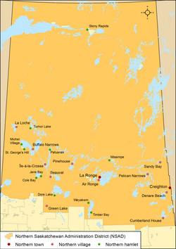
Northern municipalities Distribution of Saskatchewan's 2 northern towns, 11 northern villages and 11 northern hamlets within the Northern Saskatchewan Administration District Saskatchewan has 24 northern municipalities, which includes the sub-types of northern towns, northern villages and northern hamlets. [ 1]
Northern towns A northern town is a town in the Northern Saskatchewan Administration District . Its administration is regulated by The Northern Municipalities Act . [ 5] A northern village may apply for town status when the actual resident population is at least 500.
Saskatchewan has two northern towns. [ 1]
Northern towns of Saskatchewan Name [ 23] Incorporation [ 24] Population [ 25] [ 26] Population [ 25] Change [ 25] Land2 ) [ 25] Population2 ) [ 25] Creighton October 1, 1983 1,498 1,502 −0.3 14.39 104.1 La Ronge May 3, 1905 2,743 [ 26] 2,725 0.7 11.86 231.3 Total northern towns — 4,241 4,227 0.3 26.25 161.6
Northern villages A northern village is located in the Northern Saskatchewan Administration District, and its administration is regulated by The Northern Municipalities Act. [ 5] A northern hamlet may apply for northern village status when the population is at least 100 and the northern hamlet contains at least 50 separate dwelling units or business premises.
Saskatchewan has 11 northern villages. [ 1]
Northern villages of Saskatchewan Name [ 23] Incorporation [ 24] Population [ 25] [ 26] Population [ 25] Change [ 25] Land 2 ) [ 25] Population2 ) [ 25] Air Ronge July 13, 1977 1,043 1,032 1.1 6.00 173.8 Beauval November 14, 1969 756 806 −6.2 6.71 112.6 Buffalo Narrows April 15, 1965 1,153 1,081 6.7 68.63 16.8 Cumberland House April 15, 1965 831 [ 26] 810 2.6 15.69 53.0 Denare Beach October 1, 1983 820 [ 26] 785 4.5 5.84 140.4 Green Lake August 20, 1973 418 361 15.8 121.92 3.4 Île-à-la-Crosse April 15, 1965 1,365 1,341 1.8 23.84 57.3 La Loche November 19, 1968 2,611 2,348 11.2 15.59 167.5 Pelican Narrows October 1, 1983 790 599 31.9 3.70 213.3 Pinehouse July 6, 1979 978 1,076 −9.1 6.84 142.9 Sandy Bay April 15, 1965 1,233 1,175 4.9 14.85 83.0 Total northern villages — 11,998 11,414 5.1 289.61 41.4
Northern hamlets A northern hamlet is located in the Northern Saskatchewan Administration District, and its administration is regulated by The Northern Municipalities Act. [ 5] A northern settlement may apply for northern hamlet status when the population is at least 50 and the northern settlement contains at least 25 separate dwelling units or business premises. Unlike hamlets and northern settlements, northern hamlets are municipal corporations.
Saskatchewan has 11 northern hamlets. [ 1]
Northern hamlets of Saskatchewan Name [ 23] Incorporation [ 24] Population [ 25] [ 23] [ 26] Population [ 25] Change [ 25] Land2 ) [ 25] Population2 ) [ 25] Black Point March 26, 2008 47 [ 23] — — — — Cole Bay November 1, 1983 230 156 47.4 4.95 46.5 Dore Lake January 11, 1985 28 30 −6.7 8.03 3.5 Jans Bay October 1, 1983 187 181 3.3 5.94 31.5 Michel Village November 1, 1983 66 79 −16.5 3.73 17.7 Patuanak December 1, 1983 64 84 −23.8 1.34 47.6 St. George's Hill December 1, 1983 100 19 426.3 1.46 68.7 Stony Rapids April 1, 1992 243 255 −4.7 3.96 61.3 Timber Bay October 1, 1983 93 139 −33.1 4.44 20.9 Turnor Lake October 1, 1984 179 [ 26] 115 55.7 4.62 38.7 Weyakwin December 1, 1983 135 99 36.4 8.20 16.5 Total northern hamlets — 1,372 1,157 18.6 46.67 29.4
This page is based on this
Wikipedia article Text is available under the
CC BY-SA 4.0 license; additional terms may apply.
Images, videos and audio are available under their respective licenses.