Ridgedale is a village in the Canadian province of Saskatchewan within the Rural Municipality of Connaught No. 457 and Census Division No. 14. It is situated on the banks of the Carrot River.

Strongfield is a village in the Canadian province of Saskatchewan within the Rural Municipality of Loreburn No. 254 and Census Division No. 11. It lies approximately 100 km south of the City of Saskatoon on Highway 19 between its sister communities of Hawarden and Loreburn.

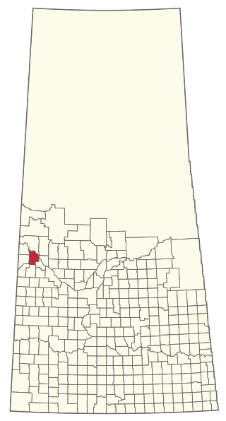
Consul is a village in the Canadian province of Saskatchewan within the Rural Municipality of Reno No. 51 and Census Division No. 4. The historic Red Coat Trail and Highway 21 pass through the village. The village features one of the last existing grain elevators in the region. It is 211 km southwest of the city of Swift Current.
Shell Lake is a village in the Canadian province of Saskatchewan within the Rural Municipality of Spiritwood No. 496 and Census Division No. 16. This village is 90 kilometres west of the City of Prince Albert. It was formerly part of the Rural Municipality (RM) of Shell Lake No. 495 before it was absorbed by the RM of Spiritwood No. 496. It is the administrative centre of the Ahtahkakoop Cree First Nation band government.

Carievale is a village in the Canadian province of Saskatchewan within the Rural Municipality of Argyle No. 1 and Census Division No. 1. The village lies at the intersection of Highway 8 and Highway 18.
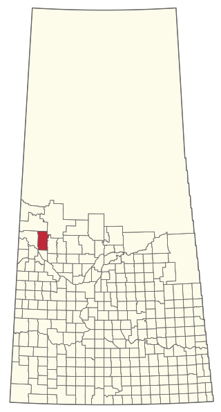
Lancer is a special service area in the Canadian province of Saskatchewan within the Rural Municipality of Miry Creek No. 229 and Census Division No. 8. It held village status between 1913 and 2022.
The Rural Municipality of Eldon No. 471 is a rural municipality (RM) in the Canadian province of Saskatchewan within Census Division No. 17 and SARM Division No. 6.
Evergreen Beach, also known as Evergreen Brightsand, is an organized hamlet in the Canadian province province of Saskatchewan under the jurisdiction of the Rural Municipality of Mervin No. 499.
Good Spirit Acres is a hamlet in the Canadian province of Saskatchewan. It is located 2 km south of Good Spirit Lake and Good Spirit Lake Provincial Park in the RM of Good Lake No. 274.
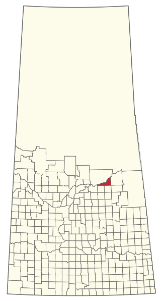
Rhein is a village in the Canadian province of Saskatchewan within the Rural Municipality of Wallace No. 243 and Census Division No. 9.
Shamrock is a village in the Canadian province of Saskatchewan within the Rural Municipality of Shamrock No. 134 and Census Division No. 7.

Tessier is a village in the Canadian province of Saskatchewan within the Rural Municipality of Harris No. 316 and Census Division No. 12. The village is located approximately 60 km southwest of the City of Saskatoon on Highway 7.
Waldron is a village in the Canadian province of Saskatchewan within the Rural Municipality of Grayson No. 184 and Census Division No. 5.
Ceylon is a village in the Canadian province of Saskatchewan within the Rural Municipality of The Gap No. 39 and Census Division No. 2. It is located alongside Gibson Creek, which is a tributary of Long Creek. No shops or businesses other than the bar remain.

The Rural Municipality of Benson No. 35 is a rural municipality (RM) in the Canadian province of Saskatchewan within Census Division No. 1 and SARM Division No. 1. It is located in the southeast portion of the province.

The Rural Municipality of Ituna Bon Accord No. 246 is a rural municipality (RM) in the Canadian province of Saskatchewan within Census Division No. 10 and SARM Division No. 4.

The Rural Municipality of Mount Hope No. 279 is a rural municipality (RM) in the Canadian province of Saskatchewan within Census Division No. 10 and SARM Division No. 5.
The Rural Municipality of Mervin No. 499 is a rural municipality (RM) in the Canadian province of Saskatchewan within Census Division No. 17 and SARM Division No. 6.
The Rural Municipality of Nipawin No. 487 is a rural municipality (RM) in the Canadian province of Saskatchewan within Census Division No. 14 and SARM Division No. 4.

The Rural Municipality of Parkdale No. 498 is a rural municipality (RM) in the Canadian province of Saskatchewan within Census Division No. 17 and SARM Division No. 6.

