Arran is a special service area in the Canadian province of Saskatchewan within the Rural Municipality of Livingston No. 331 and Census Division No. 9. It held village status between 1916 and 2022.

The Rural Municipality of Eye Hill No. 382 is a rural municipality (RM) in the Canadian province of Saskatchewan within Census Division No. 13 and SARM Division No. 6. It is located in the west-central portion of the province adjacent to the Alberta boundary.

The Rural Municipality of The Gap No. 39 is a rural municipality (RM) in the Canadian province of Saskatchewan within Census Division No. 2 and SARM Division No. 2.

The Rural Municipality of Wellington No. 97 is a rural municipality (RM) in the Canadian province of Saskatchewan within Census Division No. 2 and SARM Division No. 1. It is located in the southeast portion of the province.
Dafoe is a special service area in the Canadian province of Saskatchewan within the Rural Municipality of Big Quill No. 308 and Census Division No. 10. It was a village prior to August 2018. Dafoe is located east of the intersection of Highway 6 and the Yellowhead Highway southwest of Big Quill Lake, the Dafoe Brook flows to the east of the community. Dafoe marks the far west end of the area known to Icelandic settlers in Saskatchewan as the Lakes Settlement.
Denzil is a village in the Canadian province of Saskatchewan within the Rural Municipality of Eye Hill No. 382 and Census Division No. 13.
Dorintosh is a village in the Canadian province of Saskatchewan within the Rural Municipality of Meadow Lake No. 588 and Census Division No. 17.
Duff is a special service area in the Canadian province of Saskatchewan within the Rural Municipality of Stanley No. 215 and Census Division No. 5. It is approximately 122 kilometres (76 mi) north-east of the city of Regina, 66 kilometres (41 mi) south-west of Yorkton, and 20 kilometres (12 mi) west of Melville. The community is situated along Highway 10.
Keeler is a special service area in the Canadian province of Saskatchewan within the Rural Municipality of Marquis No. 191 and Census Division No. 7. It held village status prior to 2021.
Kennedy is a village in the Canadian province of Saskatchewan within the Rural Municipality of Wawken No. 93 and Census Division No. 1. The village lies just south of Provincial Highway 48 about 3 km west of Highway 9.
Lancer is a special service area in the Canadian province of Saskatchewan within the Rural Municipality of Miry Creek No. 229 and Census Division No. 8. It held village status between 1913 and 2022.
Plunkett is a special service area in the Canadian province of Saskatchewan within the Rural Municipality of Viscount No. 341 and Census Division No. 11. It held village status between 1921 and 2022.

Sceptre is a special service area in the Canadian province of Saskatchewan within the Rural Municipality of Clinworth No. 230 and Census Division No. 8. It held village status between 1913 and 2022.
Success is a special service area in the Canadian province of Saskatchewan within the Rural Municipality of Riverside No. 168 and Census Division No. 8. It held village status between 1912 and 2022.
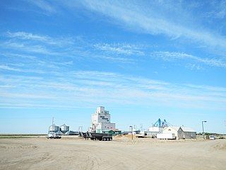
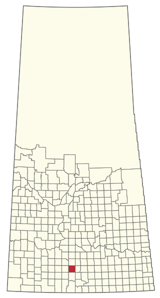
Tribune is an unincorporated community in the Rural Municipality of Souris Valley No. 7, Saskatchewan, Canada that held village status prior to 2018. It is located approximately 25 kilometres (16 mi) from the Canada–US border along Saskatchewan Highway 35. In 2016, the population was 45.
Windthorst is a village in the Canadian province of Saskatchewan within the Rural Municipality of Chester No. 125 and Census Division No. 5. It is accessed from Highway 48.
The Rural Municipality of Sutton No. 103 is a rural municipality (RM) in the Canadian province of Saskatchewan within Census Division No. 3 and SARM Division No. 2.

The Rural Municipality of Clinworth No. 230 is a rural municipality (RM) in the Canadian province of Saskatchewan within Census Division No. 8 and SARM Division No. 3.

The Rural Municipality of Pleasantdale No. 398 is a rural municipality (RM) in the Canadian province of Saskatchewan within Census Division No. 14 and SARM Division No. 4.

The Rural Municipality of Reford No. 379 is a rural municipality (RM) in the Canadian province of Saskatchewan within Census Division No. 13 and SARM Division No. 6.


