Division No. 18, Saskatchewan

Last updated

Division No. 18
Northern Saskatchewan Administration District.svg
Location within Saskatchewan
CountryCanada
Province Saskatchewan
District Northern Saskatchewan Administration District
Area
  Total269,997.26 km2 (104,246.52 sq mi)
 As of 2016
Population
 (2016)
  Total37,064
  Density0.14/km2 (0.36/sq mi)

Division No. 18, Saskatchewan, Canada, [1] [2] is one of the eighteen Statistics Canada census divisions within the province, occupying the northern half of the province. The census division is coextensive with the Northern Saskatchewan Administration District (NSAD).

Contents

The census division is the largest in the province terms of area at 269,996.55 km2 (104,246.25 sq mi), representing 46 per cent of the province's entire area of 588,239.21 km2 (227,120.43 sq mi). [3]

The most populous communities in the census division are La Ronge and La Loche with populations of 2,743 and 2,611 respectively. [4] [5]

Demographics

In the 2021 Census of Population conducted by Statistics Canada, Division No. 18 had a population of 35,986 living in 10,475 of its 12,843 total private dwellings, a change of

Census subdivisions

Division No. 18 has 58 census subdivisions, of which 24 are municipalities (including a portion of the City of Flin Flon, a city bisected by the Saskatchewan-Manitoba border, 2 northern towns, 11 northern villages and 10 northern hamlets), 32 are First Nations communities (31 Indian reserves and an Indian settlement), an unincorporated northern settlement and the unorganized balance of Division No. 18. All municipalities within the census division, except for the Northern Hamlet of Black Point, are recognized as census subdivisions.

City

NameStatus [4] [7] Population
(2011) [4] [5]
Population
(2006) [4]
Change
(%) [4]
Area
(km2) [4]
Population
density [4]
Flin Flon (part)City229242−5.42.3796.4

Northern towns

NameStatus [4] [7] Population
(2011) [4] [5]
Population
(2006) [4]
Change
(%) [4]
Area
(km2) [4]
Population
density [4]
Creighton Northern town1,4981,502−0.314.39104.1
La Ronge Northern town2,743 [5] 2,7250.711.86231.4

Northern villages

NameStatus [4] [7] Population
(2011) [4] [5]
Population
(2006) [4]
Change
(%) [4]
Area
(km2) [4]
Population
density [4]
Air Ronge Northern village1,0431,0321.16173.8
Beauval Northern village756806−6.26.71112.6
Buffalo Narrows Northern village1,1531,0816.768.6316.8
Cumberland House Northern village772810−4.715.6949.2
Denare Beach Northern village669785−14.85.84114.5
Green Lake Northern village41836115.8121.923.4
Île-à-la-Crosse Northern village1,3651,3411.823.8457.3
La Loche Northern village2,6112,34811.215.59167.5
Pelican Narrows Northern village79059931.93.7213.3
Pinehouse Northern village9781,076−9.16.84142.9
Sandy Bay Northern village1,2331,1754.914.8583

Northern hamlets

NameStatus [4] [7] Population
(2011) [4] [5]
Population
(2006) [4]
Change
(%) [4]
Area
(km2) [4]
Population
density [4]
Unorganized Division No. 18 Unorganized1,6411,18139268,389.990
Cole Bay Northern hamlet23015647.44.9546.5
Dore Lake Northern hamlet2830−6.78.033.5
Jans Bay Northern hamlet1871813.35.9431.5
Michel Village Northern hamlet6679−16.53.7317.7
Patuanak Northern hamlet6484−23.81.3447.6
St. George's Hill Northern hamlet10019426.31.4668.7
Stony Rapids Northern hamlet243255−4.73.9661.3
Timber Bay Northern hamlet93139−33.14.4420.9
Turnor Lake Northern hamlet0115−1004.620
Weyakwin Northern hamlet1359936.48.216.5

Indian settlement

NameStatus [4] [7] Population
(2011) [4] [5]
Population
(2006) [4]
Change
(%) [4]
Area
(km2) [4]
Population
density [4]
Brabant Lake Indian settlement5166−22.73.7113.7

Indian reserves

NameStatus [4] [7] Population
(2011) [4] [5]
Population
(2006) [4]
Change
(%) [4]
Area
(km2) [4]
Population
density [4]
Buffalo River Dene Nation 193 (Peter Pond Lake 193) Indian reserve7647413.186.328.9
Canoe Lake 165 Indian reserve716822−12.925.7127.9
Chicken 224 Indian reserve1,0701,109−3.5234.444.6
Chicken 225 Indian reserve046−100210
Clearwater River Dene 222 Indian reserve77865818.230.525.5
Clearwater River Dene Band 223 Indian reserve191526.79.662
Cumberland House Cree Nation 20 Indian reserve71559520.216.4843.4
Fond du Lac 227 Indian reserve8748019.1138.266.3
Fond du Lac 229 Indian reserve0088.420
Fond du Lac 231 Indian reserve0017.440
Fond du Lac 232 Indian reserve0017.830
Four Portages 157C Indian reserve008.020
Grandmother's Bay 219 Indian reserve3373205.349.76.8
Kimosom Pwatinahk 203 (Deschambault Lake) Indian reserve1,19482145.48.04148.5
Kinoosao-Thomas Clark 204 Indian reserve4057−29.80.4294.7
Kitsakie 156B Indian reserve644671−41.06606.6
La Plonge 192 Indian reserve115139−17.391.221.3
Lac La Hache 220 Indian reserve1,25198826.6110.8711.3
Lac La Ronge 156 Indian reserve1,9141,53424.89.1210.2
Little Hills 158 Indian reserve05−1006.580
Little Hills 158B Indian reserve05−1002.040
Montreal Lake 106 Indian reserve99988013.560.9616.4
Morin Lake 217 Indian reserve61840652.2105.945.8
Pelican Narrows 184B Indian reserve1,9131,34242.55.46350.5
Potato River 156A Indian reserve003.730
Southend 200 Indian reserve904910−0.737.6424
Stanley 157 Indian reserve1,6341,46711.43.13522.1
Sturgeon Weir 184F Indian reserve6166−7.624.112.5
Sucker River 156C (Nemebien River 156C) Indian reserve40029037.91.38289.2
Turnor Lake 193B Indian reserve4194131.51.12375.4
Wapachewunak 192D Indian reserve482526−8.419.4824.7

Unincorporated communities

A northern settlement is an unincorporated community in the Northern Saskatchewan Administration District, and its administration is regulated by The Northern Municipalities Act. [8] Saskatchewan has 11 northern settlements. [7] One northern settlement, Missinipe, is recognized as a census subdivision by Statistics Canada.

Name [9] Population
(2011) [9]
Bear Creek 47
Brabant Lake 102
Camsell Portage 37
Descharme Lake 42
Garson Lake 34
Missinipe 39 [4]
Sled Lake 35
Southend 35
Stanley Mission 124
Uranium City 201
Wollaston Lake 129

See also

Related Research Articles

<span class="mw-page-title-main">Rural Municipality of Wreford No. 280</span> Rural municipality in Saskatchewan, Canada

The Rural Municipality of Wreford No. 280 is a rural municipality (RM) in the Canadian province of Saskatchewan within Census Division No. 11 and SARM Division No. 5. Located in the south-central portion of the province, it is north of the city of Regina.

<span class="mw-page-title-main">Rural Municipality of McCraney No. 282</span> Rural municipality in Saskatchewan, Canada

The Rural Municipality of McCraney No. 282 is a rural municipality (RM) in the Canadian province of Saskatchewan within Census Division No. 11 and SARM Division No. 5. It is located in the south-central portion of the province.

<span class="mw-page-title-main">Rural Municipality of Lone Tree No. 18</span> Rural municipality in Saskatchewan, Canada

The Rural Municipality of Lone Tree No. 18 is a rural municipality (RM) in the Canadian province of Saskatchewan within Census Division No. 4 and SARM Division No. 3. Located in the southwest portion of the province, it is southwest of the city of Swift Current. It is adjacent to the United States border, neighbouring Blaine County and Phillips County in Montana.

Marquis is a village in the Canadian province of Saskatchewan within the Rural Municipality of Marquis No. 191 and Census Division No. 7. It is on Highway 42 about 32 km northwest of Moose Jaw.

<span class="mw-page-title-main">Disley, Saskatchewan</span> Village in Saskatchewan, Canada

Disley is a village in the Canadian province of Saskatchewan within the Rural Municipality of Lumsden No. 189 and Census Division No. 6. It is located 18 km (11 mi) west of Lumsden just south of the Louis Riel Trail and 48 kilometres northwest of the City of Regina.

Jans Bay is a northern hamlet in the Canadian province of Saskatchewan.

<span class="mw-page-title-main">Meacham, Saskatchewan</span> Village in Saskatchewan, Canada

Meacham is a village in the Canadian province of Saskatchewan within the Rural Municipality of Colonsay No. 342 and Census Division No. 11. It is located 69 kilometres east of the City of Saskatoon on Highway 2.

Meath Park is a village in the Canadian province of Saskatchewan within the Rural Municipality of Garden River No. 490 and Census Division No. 15.

Middle Lake is a village in the Canadian province of Saskatchewan within the Rural Municipality of Three Lakes No. 400 and Census Division No. 15. The village has a public K-12 school, a nursing home, and a regional park. It is adjacent to Lucien Lake and accessed from Highway 20. The surrounding area is largely agricultural.

<span class="mw-page-title-main">Rural Municipality of Viscount No. 341</span> Rural municipality in Saskatchewan, Canada

The Rural Municipality of Viscount No. 341 is a rural municipality (RM) in the Canadian province of Saskatchewan within Census Division No. 11 and SARM Division No. 5. It is located in the central portion of the province.

<span class="mw-page-title-main">Rural Municipality of Insinger No. 275</span> Rural municipality in Saskatchewan, Canada

The Rural Municipality of Insinger No. 275 is a rural municipality (RM) in the Canadian province of Saskatchewan within Census Division No. 9 and SARM Division No. 4. It is located in the east-central portion of the province.

St. Benedict is a village in the Canadian province of Saskatchewan within the Rural Municipality of Three Lakes No. 400 and Census Division No. 15. Located in the Carlton Trail Region of the province, it is 56 km (35 mi) north of the City of Humboldt off Highway 20.

<span class="mw-page-title-main">Rural Municipality of Wallace No. 243</span> Rural municipality in Saskatchewan, Canada

The Rural Municipality of Wallace No. 243 is a rural municipality (RM) in the Canadian province of Saskatchewan within Census Division No. 9 and SARM Division No. 4. It is located in the east-central portion of the province.

<span class="mw-page-title-main">Rural Municipality of Glen Bain No. 105</span> Rural municipality in Saskatchewan, Canada

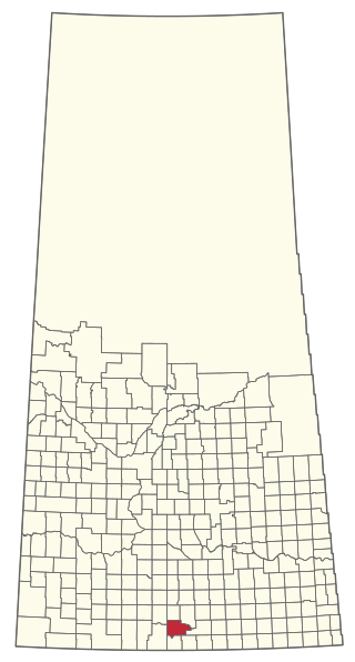
The Rural Municipality of Glen Bain No. 105 is a rural municipality (RM) in the Canadian province of Saskatchewan within Census Division No. 3 and SARM Division No. 3. It is located in the south-central portion of the province.

<span class="mw-page-title-main">Rural Municipality of Poplar Valley No. 12</span> Rural municipality in Saskatchewan, Canada

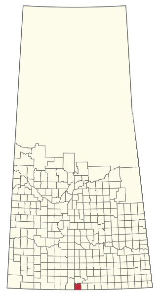
The Rural Municipality of Poplar Valley No. 12 is a rural municipality (RM) in the Canadian province of Saskatchewan within Census Division No. 3 and SARM Division No. 2. It is located in the southern portion of the province. It is adjacent to the United States border, neighbouring Daniels County in Montana.
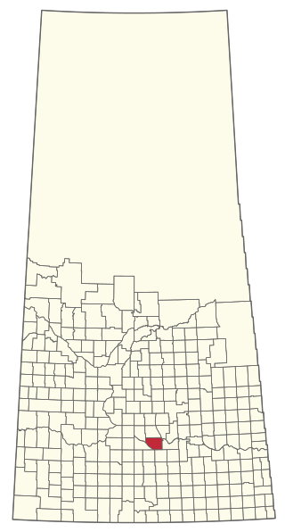
<span class="mw-page-title-main">Rural Municipality of Scott No. 98</span> Rural municipality in Saskatchewan, Canada

The Rural Municipality of Scott No. 98 is a rural municipality (RM) in the Canadian province of Saskatchewan within Census Division No. 2 and SARM Division No. 2. It is located in the southeast portion of the province.

<span class="mw-page-title-main">Rural Municipality of Rodgers No. 133</span> Rural municipality in Saskatchewan, Canada

The Rural Municipality of Rodgers No. 133 is a rural municipality (RM) in the Canadian province of Saskatchewan within Census Division No. 7 and SARM Division No. 2.

<span class="mw-page-title-main">Rural Municipality of Montrose No. 315</span> Rural municipality in Saskatchewan, Canada

The Rural Municipality of Montrose No. 315 is a rural municipality (RM) in the Canadian province of Saskatchewan within Census Division No. 12 and SARM Division No. 5.

References

  1. "Census Profile: Division No. 18, Census division (Census Division), Saskatchewan (map)". Statistics Canada. Archived from the original on 24 December 2013. Retrieved 21 December 2012.
  2. "Northern Administration District". Saskatchewan Ministry of Municipal Affairs. Archived from the original on 16 January 2013. Retrieved 21 December 2012.
  3. "Division No. 18, Saskatchewan (Code 4718) and Saskatchewan (Code 47) (table). Census Profile". Statistics Canada. Archived from the original on 22 March 2014. Retrieved 21 December 2012.
  4. 1 2 3 4 5 6 7 8 9 10 11 12 13 14 15 16 17 18 19 20 21 22 23 24 25 26 27 28 29 30 31 32 33 34 35 36 37 38 "Population and dwelling counts, for Canada, provinces and territories, census divisions, and census subdivisions (municipalities), 2011 and 2006 censuses (Saskatchewan)". Statistics Canada. Retrieved 21 December 2012.
  5. 1 2 3 4 5 6 7 8 "Corrections and updates". Statistics Canada. 24 October 2012. Retrieved 21 December 2012.
  6. "Population and dwelling counts: Canada and census divisions". Statistics Canada. 9 February 2022. Retrieved 2 April 2022.
  7. 1 2 3 4 5 6 7 "Types of Municipalities". Saskatchewan Ministry of Municipal Affairs. Archived from the original on 19 September 2012. Retrieved 21 December 2012.
  8. "The Northern Municipalities Act" (PDF). Saskatchewan Queen's Printer. Retrieved 21 December 2012.
  9. 1 2 "Search for Municipal Information". Saskatchewan Ministry of Municipal Affairs. Archived from the original on 10 March 2014. Retrieved 21 December 2012.

55°06′N105°18′W / 55.100°N 105.300°W / 55.100; -105.300