Rural Municipality of Kelsey

Last updated
Kelsey
Rural Municipality of Kelsey
CAN MB Kelsey.svg
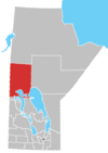
Location within Manitoba
Coordinates: 53°44′08″N101°23′42″W / 53.73556°N 101.39500°W / 53.73556; -101.39500 Coordinates: 53°44′08″N101°23′42″W / 53.73556°N 101.39500°W / 53.73556; -101.39500
CountryCanada
Province Manitoba
Federal riding Churchill—Keewatinook Aski
Provincial riding The Pas-Kameesak
Government
[1]
   Reeve Rod Berezowecki
  Office location The Pas
Area
  Total867.64 km2 (335.00 sq mi)
Population
 (2016)
  Total2,424
Postal code
R9A 1K6
Website Official website

Kelsey is a Manitoban rural municipality embedded within the province's Northern Region. It consists of several disjoint parts. The largest part is Carrot Valley, located around and southwest of The Pas along the Carrot River, but the communities of Wanless and Cranberry Portage, located further north, are also part of the municipality. It is 867.64 km2 large. Also lying in the area around The Pas is the Opaskwayak Cree Nation Indian reserve.

Contents

Communities

Demographics

In the 2021 Census of Population conducted by Statistics Canada, Kelsey had a population of 2,181 living in 857 of its 1,041 total private dwellings, a change of

According to the 2011 National Household Survey, [3] the population of Kelsey is 2,125. The population density was 2.6 per km2. The racial make up of Kelsey is solely made up of Aboriginals (44.0%); First Nations (23.1%) and Metis (20.7%), and Whites (56.0%). The religious make up of Kelsey is; Christian (74.5%), non-religious (25.5%). Every resident of Kelsey is a Canadian citizen. About 4.0% of the population can speak a language that is not recognized as an official language of Canada.

Sources

  1. Municipal Officials Directory (PDF). Winnipeg, Manitoba: Manitoba Municipal Relations. 2019.
  2. "Population and dwelling counts: Canada, provinces and territories, and census subdivisions (municipalities), Manitoba". Statistics Canada. February 9, 2022. Retrieved February 20, 2022.
  3. "NHS Profile, Kelsey, RM, Manitoba, 2011". Statistics Canada. Retrieved November 23, 2021.


Related Research Articles

Rivers, Manitoba Unincorporated community in Manitoba, Canada

Rivers is an unincorporated urban community in the Riverdale Municipality within the Canadian province of Manitoba. It is located 40 kilometres (25 mi) northwest of Brandon, 473 metres (1,552 ft) above sea level. It is within the Westman Region. Agriculture, health and related businesses provide income for the community and area. Rivers has a population of 1,257 people in the 2016 census.

Rural Municipality of Cartier Rural municipality in Manitoba, Canada

Rural Municipality of Cartier is a rural municipality in the Central Plains and Metro Regions of Manitoba, Canada. The municipality is bordered on the west by the RM of Portage la Prairie, to the east by the RM of Headingley, and to the north by the Assiniboine River. It is mainly flat rich farmland. Its main town is Elie.

Lacombe County Municipal district in Alberta, Canada

Lacombe County is a municipal district in central Alberta, Canada. It is within in Census Division No. 8 north of the City of Red Deer. Its municipal office is 4 km (2.5 mi) west of Highway 2 and the City of Lacombe, and 6 km (3.7 mi) east of the Summer Village of Gull Lake, at the intersection of Highway 12 and Spruceville Road.

Wanless is an unincorporated hamlet in the province of Manitoba, Canada. It is located approximately 50 km (31 mi) north of The Pas, close to Rocky Lake, within the Rural Municipality of Kelsey. Wanless had an estimated population of 183 in the mid-2010s. The place was named after homesteader Jack Wanless. Wanless is the only community in the Rural Municipality of Kelsey to be an enclave surrounded by land ungoverned by a municipality, besides Cranberry Portage. Wanless is served by the Manitoba Highway 10.

Rural Municipality of Gull Lake No. 139 Rural municipality in Saskatchewan, Canada

The Rural Municipality of Gull Lake No. 139 is a rural municipality (RM) in the Canadian province of Saskatchewan within Census Division No. 8 and SARM Division No. 3. It is located in the southwest portion of the province.

Anzac is a hamlet in northern Alberta, Canada within the Regional Municipality (RM) of Wood Buffalo. It is located on Highway 881 along the east shore of Gregoire Lake, approximately 36 kilometres (22 mi) southeast of Fort McMurray.

Rural Municipality of Cornwallis Rural municipality in Manitoba, Canada

Cornwallis is a rural municipality located in the Canadian province of Manitoba. It surrounds the east, south and west sides of Brandon, Manitoba. Most of the land comprising the municipality is farmland, but it contains a few settlements. One of the larger settlements, Sprucewoods, sits at the north gate of Canadian Forces Base Shilo and contains a large group of the municipal population. In the past, there has been friction between the community and the farming base that make up much of Cornwallis.

Woodlands is a rural municipality in the province of Manitoba in Western Canada. It lies in the southern part of the Interlake and is named for the community of Woodlands, which itself is named for the wooded lands of the area.

Rural Municipality of Argyle Rural municipality in Manitoba, Canada

Argyle is a rural municipality in the province of Manitoba in Western Canada. It was incorporated on 15 August 1881 and is named after John Campbell, 9th Duke of Argyll who was the fourth Governor General of Canada.

Rural Municipality of Mossey River Rural municipality in Manitoba, Canada

The Rural Municipality of Mossey River is a rural municipality in the Parkland Region of Manitoba, Canada, located at the south end of Lake Winnipegosis.

Portage la Prairie is a rural municipality in the province of Manitoba in Western Canada. It surrounds the city of Portage la Prairie, Manitoba's fourth-largest city. Also within the borders of the municipality are the Dakota Plains First Nation and most of the Long Plain First Nation Indian reserves.

Rural Municipality of Lake of the Rivers No. 72 Rural municipality in Saskatchewan, Canada

The Rural Municipality of Lake of the Rivers No. 72 is a rural municipality (RM) in the Canadian province of Saskatchewan within Census Division No. 3 and SARM Division No. 2. It is located in the southwest portion of the province.

Rural Municipality of Moose Range No. 486 Rural municipality in Saskatchewan, Canada

The Rural Municipality of Moose Range No. 486 is a rural municipality (RM) in the Canadian province of Saskatchewan within Census Division No. 14 and SARM Division No. 4.

The Rural Municipality of St. Laurent is located in the Interlake Region of Manitoba and has Lake Manitoba as its western boundary and is serviced by Manitoba Highway 6. The community of St. Laurent lies within its boundaries.

The Municipality of Grassland is a rural municipality (RM) in the Canadian province of Manitoba.

The Municipality of North Norfolk is a rural municipality (RM) in the Canadian province of Manitoba.

The Rural Municipality of Oakview is a rural municipality (RM) in the Canadian province of Manitoba, incorporated on January 1, 2015 as a result of the amalgamation of the rural municipalities of Blanshard, Saskatchewan, and the Town of Rapid City. It was formed as a requirement of The Municipal Amalgamations Act, which required that municipalities with a population less than 1,000 amalgamate with one or more neighbouring municipalities by 2015. The Government of Manitoba initiated these amalgamations in order for municipalities to meet the 1997 minimum population requirement of 1,000 to incorporate a municipality.

The Municipality of Souris – Glenwood is a rural municipality (RM) in the Canadian province of Manitoba.