Rural Municipality of Dufferin

Last updated

Dufferin
Rural Municipality of Dufferin
CAN MB Dufferin.svg
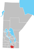
Location of Dufferin in Manitoba
Coordinates: 49°31′55″N98°04′12″W / 49.53194°N 98.07000°W / 49.53194; -98.07000 Coordinates: 49°31′55″N98°04′12″W / 49.53194°N 98.07000°W / 49.53194; -98.07000
CountryCanada
Province Manitoba
IncorporatedNovember 1, 1890
Area
  Total916.11 km2 (353.71 sq mi)
Population
 (2021) [1]
  Total2,543
  Density2.8/km2 (7.2/sq mi)
Time zone UTC-6 (CST)
  Summer (DST) UTC-5 (CDT)

Dufferin is a rural municipality in the province of Manitoba in Western Canada. The separately administered town of Carman lies near its centre.

Contents

The R.M. was named after Frederick Hamilton-Temple-Blackwood, 1st Marquess of Dufferin and Ava who was Governor General of Canada (1872–78). The now rural municipality was described as a new settlement in 1874.
Communities

Demographics

In the 2021 Census of Population conducted by Statistics Canada, Dufferin had a population of 2,543 living in 761 of its 806 total private dwellings, a change of

Related Research Articles

<span class="mw-page-title-main">Carman, Manitoba</span> Place in Manitoba, Canada

Carman is a small agricultural town of about 3,000 people in the Pembina Valley Region of southern Manitoba, Canada. Carman is at the junction of Highways 3 and 13, 40 minutes southwest of Winnipeg. It is surrounded by the Rural Municipality of Dufferin, in the heart of a rich prairie agricultural belt, 60 km (37 mi) north of the American state of North Dakota.

<span class="mw-page-title-main">Rural Municipality of St. Clements</span> Rural municipality in Manitoba, Canada

St. Clements is a rural municipality in Manitoba, Canada. It is located to the north-east of Winnipeg, stretching from East St. Paul and Birds Hill Provincial Park in the south to Lake Winnipeg and Grand Beach Provincial Park to the north. The Red River demarcates the western boundary of the municipality. St. Clements contains the communities of East Selkirk, and Lockport east of the Red River. It almost completely surrounds the Brokenhead 4 Indian reserve, with the exception of a small lakefront on Lake Winnipeg.

<span class="mw-page-title-main">Rural Municipality of Dufferin No. 190</span> Rural Municipality in Saskatchewan, Canada

The Rural Municipality of Dufferin No. 190 is a rural municipality (RM) in the Canadian province of Saskatchewan within Census Division No. 6 and SARM Division No. 2. It is located in the south-central portion of the province.

<span class="mw-page-title-main">Rural Municipality of Reynolds</span> Rural municipality

The Rural Municipality of Reynolds is a rural municipality in southeastern Manitoba, Canada.

<span class="mw-page-title-main">Division No. 3, Manitoba</span> Census division in Manitoba, Canada

Division No. 3 is a census division located within the Pembina Valley Region in the south-central region of the province of Manitoba, Canada. Unlike in some other provinces, census divisions do not reflect the organization of local government in Manitoba. These areas exist solely for the purposes of statistical analysis and presentation; they have no government of their own.

<span class="mw-page-title-main">Rural Municipality of Cornwallis</span> Rural municipality in Manitoba, Canada

Cornwallis is a rural municipality located in the Canadian province of Manitoba. It surrounds the east, south and west sides of Brandon, Manitoba. Most of the land comprising the municipality is farmland, but it contains a few settlements. One of the larger settlements, Sprucewoods, sits at the north gate of Canadian Forces Base Shilo and contains a large group of the municipal population. In the past, there has been friction between the community and the farming base that make up much of Cornwallis.

<span class="mw-page-title-main">Rural Municipality of De Salaberry</span> Rural municipality in Manitoba, Canada

De Salaberry is a rural municipality in the province of Manitoba in western Canada. The administratively separate village of St-Pierre-Jolys and St. Malo Provincial Park lie within the geographical borders of the municipality. The municipality is named after Charles de Salaberry.

<span class="mw-page-title-main">Rural Municipality of Fisher</span> Rural municipality in Manitoba, Canada

Fisher is a rural municipality in the Canadian province of Manitoba.

<span class="mw-page-title-main">Rural Municipality of Grahamdale</span> Rural municipality in Manitoba, Canada

Grahamdale is a rural municipality (RM) in the province of Manitoba in Western Canada. It lies in the Interlake Region. It was incorporated as a Local Government District (LGD) on 1 January 1945, and became a Rural Municipality in 1997.

<span class="mw-page-title-main">Rural Municipality of Montcalm</span> Rural municipality in Manitoba, Canada

Montcalm is a rural municipality (RM) in the province of Manitoba in Western Canada. The Canada 2016 Census reported a population of 1,260 persons, a decrease from the 1,309 reported in the 2011 Census.

<span class="mw-page-title-main">Rural Municipality of Stanley</span> Rural municipality in Manitoba, Canada

Stanley is a rural municipality (RM) in the province of Manitoba in Western Canada. It is located in the southern part of the province, along its border with the state of North Dakota in the United States. Since 1876, the area made up part of the Mennonite West Reserve. The municipality has a population of 8,969 as of the 2016 Canada Census. The cities of Winkler and Morden lie geographically within the municipality but are separate urban municipalities.

<span class="mw-page-title-main">Rural Municipality of Alonsa</span> Rural municipality in Manitoba, Canada

Alonsa is a rural municipality (RM) in the province of Manitoba, western Canada. It lies on the west side of Lake Manitoba.

<span class="mw-page-title-main">Rural Municipality of Argyle</span> Rural municipality in Manitoba, Canada

Argyle is a rural municipality in the province of Manitoba in Western Canada. It was incorporated on 15 August 1881 and is named after John Campbell, 9th Duke of Argyll who was the fourth Governor General of Canada.

<span class="mw-page-title-main">Rural Municipality of Pipestone</span> Rural municipality in Manitoba, Canada

Pipestone is a rural municipality in the southwestern part of the province of Manitoba in Western Canada

<span class="mw-page-title-main">Rural Municipality of Portage la Prairie</span> Rural municipality in Manitoba, Canada

Portage la Prairie is a rural municipality in the province of Manitoba in Western Canada. It surrounds the city of Portage la Prairie, Manitoba's fifth-largest city. Also within the borders of the municipality are the Dakota Plains First Nation and most of the Long Plain First Nation Indian reserves.

<span class="mw-page-title-main">Rural Municipality of Roland</span> Rural municipality in Manitoba, Canada

Roland is a rural municipality located in the Pembina Valley Region of Manitoba, Canada. According to the Canada 2016 Census, it has a population of 1,129.

<span class="mw-page-title-main">Rural Municipality of Thompson</span> Rural municipality in Manitoba, Canada

Thompson is a rural municipality in the Pembina Valley Region of Manitoba, Canada. It had a population of 1,259 according to the Canada 2006 Census.

<span class="mw-page-title-main">Rural Municipality of Elton</span> Rural municipality in Manitoba, Canada

Elton is a rural municipality in the Canadian province of Manitoba, located to the north of the city of Brandon. The community was incorporated in 1883, and its first officials took office the following year.

<span class="mw-page-title-main">Municipality of Emerson – Franklin</span> Rural municipality in Manitoba, Canada

The Municipality of Emerson – Franklin is a rural municipality (RM) in the Canadian province of Manitoba.

<span class="mw-page-title-main">Rossburn Municipality</span> Rural municipality in Manitoba, Canada

Rossburn Municipality is a rural municipality (RM) in the Parkland Region of Manitoba, Canada.

References

  1. 1 2 "Population and dwelling counts: Canada, provinces and territories, and census subdivisions (municipalities), Manitoba". Statistics Canada. February 9, 2022. Retrieved February 20, 2022.