Pinawa

Last updated
Pinawa
Pinawa Dam.jpg
Decommissioned hydroelectric dam at old Pinawa on the Lee River
CAN MB Whitemouth.svg
Pinawa is a small local government district located just north of the Rural Municipality of Whitemouth (the latter being highlighted in red)
CountryCanada
Province Manitoba
Region Eastman
Government
   MP (Selkirk—Interlake—Eastman) James Bezan (CPC)
Area
  Total1.55 km2 (0.60 sq mi)
Population
 (2016)
  Total1,331 [1]
  Density856.1/km2 (2,217/sq mi)
  Change 2011–16
Increase2.svg0.5%
Time zone UTC-6 (CST)
  Summer (DST) UTC-5 (CDT)

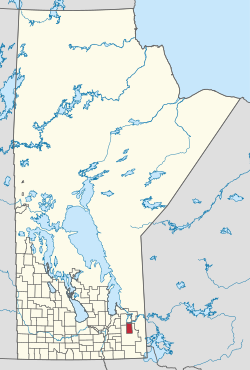
Pinawa is a local government district and small community of 1,331 residents (2016 census) located in southeastern Manitoba, Canada. It is 110 kilometres north-east of Winnipeg. The town is situated on the Canadian Shield within the western boundary of Whiteshell Provincial Park, which lies near the Manitoba-Ontario provincial boundary. Administratively, the town includes the surrounding area, and is officially the Local Government District of Pinawa. Except for a small eastern border with the unorganized area of the Eastman Region, it is surrounded by the Rural Municipalities of Lac du Bonnet to the north and Whitemouth to the south, but is independent of either one. The community lies on the north bank of the Winnipeg River in the southeastern part of the Local Government District.

Contents

History

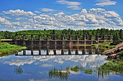
The community of Pinawa was established in 1901 to support the operation of an early hydroelectric generating station but was abandoned in 1951 when the site was shut down.

Pinawa was re-established about 10 km from the original Hydro town in 1963 when Atomic Energy of Canada Limited built the Whiteshell Laboratories nuclear research facility in the area. Pinawa was chosen as the site for the research station due to the seismic stability of the area. Pinawa was developed as a planned community which preserved many of the natural features of the site and designated all riverfront property as public reserve.

Whiteshell Laboratories was somewhat similar to the Chalk River Nuclear Laboratories in Chalk River, Ontario. AECL began decommissioning the Whiteshell Laboratories in 1998. The economy of Pinawa is diversifying and now includes small recreation and resort businesses and a number of environmental science firms.

Geography

Pinawa is located beside the Winnipeg River, which offers access to boating, kayaking, canoeing, and other water recreational activities. Other attractions include an 18-hole golf course, beach, outdoor pool, tennis courts, a curling rink, a hockey arena and many kilometres of cross-country ski trails.

The Trans-Canada Trail runs through the town of Pinawa along the Riverside. Pinawa also hosts the Eastern Manitoba Concert Association or EMCA's concerts, held in the community centre's gymnasium in the secondary school building once a month between October and April.

Pinawa is also home to an abundance of wildlife, including deer, bears, and other species. The people of Pinawa are very familiar with white-tailed deer, although their views on them may differ. Five deer in the backyard is a common sight there, and the town is known as the Deer Capital of Manitoba.

Climate

Pinawa has a humid continental climate (Köppen climate classification Dfb) with warm summers and severely cold winters. Precipitation is moderate, but is somewhat higher in summer than at other times of the year.

Climate data for Pinawa
MonthJanFebMarAprMayJunJulAugSepOctNovDecYear
Record high °C (°F)8
(46)
12
(54)
20
(68)
32.5
(90.5)
34.5
(94.1)
37.5
(99.5)
35
(95)
35.5
(95.9)
36
(97)
27.2
(81.0)
23.3
(73.9)
10
(50)
37.5
(99.5)
Mean daily maximum °C (°F)−12.6
(9.3)
−7.8
(18.0)
−0.4
(31.3)
9.7
(49.5)
18.1
(64.6)
22.2
(72.0)
24.8
(76.6)
23.7
(74.7)
17.3
(63.1)
9.8
(49.6)
−1.3
(29.7)
−9.8
(14.4)
7.8
(46.0)
Daily mean °C (°F)−18.1
(−0.6)
−13.7
(7.3)
−6.2
(20.8)
3.4
(38.1)
11.4
(52.5)
16.2
(61.2)
18.9
(66.0)
17.7
(63.9)
11.8
(53.2)
5.1
(41.2)
−4.9
(23.2)
−14.5
(5.9)
2.3
(36.1)
Mean daily minimum °C (°F)−23.5
(−10.3)
−19.5
(−3.1)
−12
(10)
−2.9
(26.8)
4.7
(40.5)
10.1
(50.2)
12.9
(55.2)
11.6
(52.9)
6.3
(43.3)
0.4
(32.7)
−8.5
(16.7)
−19
(−2)
−3.3
(26.1)
Record low °C (°F)−43.9
(−47.0)
−47.8
(−54.0)
−39.4
(−38.9)
−28.9
(−20.0)
−13.9
(7.0)
−3.9
(25.0)
−0.6
(30.9)
−1.5
(29.3)
−6.7
(19.9)
−15.5
(4.1)
−34.5
(−30.1)
−40
(−40)
−47.8
(−54.0)
Average precipitation mm (inches)21.7
(0.85)
16.9
(0.67)
27.3
(1.07)
31.9
(1.26)
59.5
(2.34)
94.5
(3.72)
78.3
(3.08)
71.5
(2.81)
64.1
(2.52)
45.5
(1.79)
30.6
(1.20)
23.7
(0.93)
565.3
(22.26)
Source: Environment Canada [2]

Demographics

In the 2021 Census of Population conducted by Statistics Canada, Pinawa had a population of 1,558 living in 708 of its 797 total private dwellings, a change of

Infrastructure

Pinawa has a full service hospital with 24 hour emergency service, doctors' offices, and an ambulance station. There is a small shopping centre with a post office, credit union, grocery store, bakery, hairdresser, and the offices. The town also has a motel, a conference centre, and an art gallery.

Education

Pinawa has two schools: F.W. Gilbert Elementary School for students in Kindergarten up to grade six, with about 85 students, and Pinawa Secondary School for grades 7–12, with about 110 students. The schools of Pinawa comprise their own school district, the School District of Whiteshell.

Pinawa Secondary School is located near the elementary school, and is well known in the Whiteshell area for its outstanding Pinawa Panther sports teams and a unique outdoor education program that takes full advantage of the surrounding wilderness. Students are involved in basketball, soccer, volleyball, badminton, and travel club as well as academic sports like Reach For The Top and community service activities such as the LIVE volunteer group.

Pinawa was also selected as host for one day of the Kraft Celebration Tour during the summer of 2010, which saw Dan O'Toole and Jay Onrait host TSN's SportsCentre in the town on August 23. The town also received a cheque for $25,000 from Kraft Canada which went towards renovating their local rink, the Orville Acres Arena.

Notable people

See also

Related Research Articles

<span class="mw-page-title-main">The Pas</span> Town in Manitoba, Canada

The Pas is a town in Manitoba, Canada, at the confluence of the Pasquia River and the Saskatchewan River and surrounded by the unorganized Northern Region of the province. It is approximately 520 kilometres (320 mi) northwest of the provincial capital, Winnipeg, and 35 kilometres (22 mi) from the border of Saskatchewan. It is sometimes still called Paskoyac by locals after the first trading post, called Fort Paskoya, constructed in the 1740s by French and Canadian traders. The Pasquia River begins in the Pasquia Hills in east central Saskatchewan. The French in 1795 knew the river as Basquiau.

<span class="mw-page-title-main">Red Deer, Alberta</span> City in Alberta, Canada

Red Deer is a city in Alberta, Canada, located midway on the Calgary–Edmonton Corridor. Red Deer serves central Alberta, and its key industries include health care, retail trade, construction, oil and gas, hospitality, manufacturing and education. It is surrounded by Red Deer County and borders on Lacombe County. The city is in aspen parkland, a region of rolling hills, alongside the Red Deer River.

<span class="mw-page-title-main">Dauphin, Manitoba</span> City in Manitoba, Canada

Dauphin is a city in Manitoba, Canada, with a population of 8,368 as of the 2021 Canadian Census. The community is surrounded by the Rural Municipality of Dauphin. The city takes its name from Lake Dauphin and Fort Dauphin, which were named by explorer Pierre Gaultier de La Vérendrye in honour of the Dauphin of France, the heir to the French throne. Dauphin is Manitoba's ninth largest community and serves as a hub to the province's Parkland Region.

<span class="mw-page-title-main">Swan River, Manitoba</span> Town in Manitoba, Canada

Swan River is a town in Manitoba, Canada. It is surrounded by the Municipality of Swan Valley West in the Swan River Valley region. According to the 2021 Canadian Census, Swan River had a population of 4,049, making it Manitoba's 18th largest in population.

<span class="mw-page-title-main">Gillam, Manitoba</span> Town in Manitoba, Canada

Gillam is a town on the Nelson River in northern Manitoba, Canada. It is situated between Thompson and Churchill on the Hudson Bay Railway line.

Snow Lake is a town in Manitoba, Canada, located 685 km north of Winnipeg at the end of Provincial Road 392. The main industry is, and always has been, mining; currently with one mine producing Zinc, and another lithium. The official Town of Snow Lake is a very large, overwhelmingly rural area that is centered about the urban community of Snow Lake, which lies very near its geographical center. The Town is as large in area as a typical rural municipality in the more southern parts of Manitoba.

The Whiteshell Laboratories, originally known as the Whiteshell Nuclear Research Establishment (WNRE) was an Atomic Energy of Canada (AECL) laboratory in Manitoba, northeast of Winnipeg. It was originally built as a home for the experimental WR-1 reactor, but over time came to host a variety of experimental systems, including a SLOWPOKE reactor and the Underground Research Laboratory to study nuclear waste disposal. Employment peaked in the early 1970s at about 1,300, but during the 1980s the experiments began to wind down, and in 2003 the decision was made to close the site. As of 2017 the site is undergoing decommissioning with a planned completion date in 2024. The decommissioning process for WR-1 involves transporting low-level nuclear waste to another Canadian Nuclear Laboratories (CNL) research site, Chalk River Laboratories in Ottawa for containment, and encasing the reactor in concrete. The details of this process continue to be criticized, evaluated, and revised.

<span class="mw-page-title-main">Rural Municipality of Dauphin</span> Rural municipality in Manitoba, Canada

Dauphin is a rural municipality in the Parkland Region of Manitoba, Canada. The municipality surrounds the separately administered city of Dauphin, and lies just north of Riding Mountain National Park, part of which extends into the RM.

St. Claude is an unincorporated community recognized as a local urban district in the Rural Municipality of Grey within the Canadian province of Manitoba that held village status prior to January 1, 2015.

<span class="mw-page-title-main">Hardisty, Alberta</span> Town in Alberta, Canada

Hardisty is a town in Flagstaff County in east-central Alberta, Canada. It is approximately 111 kilometres (69 mi) from the Saskatchewan border, near the crossroads of Highway 13 and Highway 881, in the Battle River Valley. Hardisty is mainly known as a pivotal petroleum industry hub where petroleum products such as Western Canada Select blended crude oil and Hardisty heavy oil are produced and traded.

<span class="mw-page-title-main">Eastman Region</span> Region in Manitoba, Canada

Eastern Manitoba, or the Eastman Region, is an informal geographic region of the Canadian province of Manitoba. It is bounded on the north by the Winnipeg River and Lake Winnipeg, on the east by the Manitoba-Ontario border, on the south by the Canada–US border, and on the west by the Red River. With a population of 128,855 as of the 2021 Canadian census, the Eastman Region is the second most populous region outside of the Winnipeg Metropolitan Region.

<span class="mw-page-title-main">Beausejour, Manitoba</span> Town in Manitoba, Canada

Beausejour is a town in the Canadian province of Manitoba. It is 46 kilometres northeast of Winnipeg, just west of the Canadian Shield and Whiteshell Provincial Park. The French name Beauséjour [beau + séjour] means "beautiful stay". The town is surrounded by the Rural Municipality of Brokenhead.

<span class="mw-page-title-main">Whiteshell Provincial Park</span> Provincial park in Manitoba, Canada

Whiteshell Provincial Park is a provincial park in southeast Manitoba, approximately 120 kilometres (75 mi) east of the city of Winnipeg. The park is considered to be a Class II protected area under the IUCN protected area management categories. It is 275,210 hectares in size.

<span class="mw-page-title-main">Stonewall, Manitoba</span> Town in Manitoba, Canada

Stonewall is a town in the Canadian province of Manitoba with a population of 5,046 as of the 2021 census. The town is situated approximately 25 kilometres (16 mi) north of Winnipeg on PTH 67. It is known for its limestone quarries. The local festival is the Quarry Days which is usually held over three days in August on Main Street. The town is surrounded by the R.M. of Rockwood.

<span class="mw-page-title-main">St. Adolphe, Manitoba</span> Place in Manitoba, Canada

St. Adolphe, or Saint Adolphe, originally called Pointe-Coupée, is a community in the Rural Municipality of Ritchot, Manitoba, Canada. It is located along the east bank of the Red River, approximately 12 kilometres south of Winnipeg.

<span class="mw-page-title-main">Ste. Anne</span> Place in Manitoba, Canada

Ste. Anne, or Sainte-Anne-des-Chênes, is a town in Manitoba, Canada, located about 42 km southeast of Winnipeg. The population was 2,114 in 2016, 1,524 in 2011, and 1,513 in 2011. It is known for being located on the Seine River and at the heart of the Old Dawson Trail. The town is surrounded by the Rural Municipality of Ste. Anne.

<span class="mw-page-title-main">Chalk River</span> Place in Ontario, Canada

Chalk River is a small rural village, part of the Laurentian Hills municipality in Renfrew County, Ontario, Canada. It is located in the Upper Ottawa Valley along Highway 17, 10 kilometres (6.2 mi) inland (west) from the Ottawa River, approximately 21 km (13 mi) northwest of Petawawa, and 182 km (113 mi) northwest of Ottawa. Chalk River was a separate municipality until January 1, 2000, when the United Townships of Rolph, Buchanan, Wylie and McKay and the Village of Chalk River were merged.

<span class="mw-page-title-main">Rural Municipality of Lac du Bonnet</span> Rural municipality in Manitoba, Canada

Lac du Bonnet is a rural municipality in the province of Manitoba in Western Canada, situated between the Nopiming Provincial Park to the northeast and Whiteshell Provincial Park to the southeast.

Oak Bluff is an incorporated community located in the Rural Municipality of Macdonald, Manitoba, Canada. It is situated seven kilometres southwest of the City of Winnipeg, between Manitoba Highway (PTH) 3's intersections with PTH 2 and PTH 100. The community has a population of 1,442 as of the 2021 Canadian census

References

  1. "Census Profile, 2016 Census". Statistics Canada. 2017-04-14. Retrieved 2017-05-06.
  2. "Canadian Climate Normals 1971–2000". Environment Canada. Retrieved 26 August 2012.
  3. "Population and dwelling counts: Canada, provinces and territories, and census subdivisions (municipalities), Manitoba". Statistics Canada. February 9, 2022. Retrieved February 20, 2022.