The Rural Municipality of Gimli is a rural municipality located in the Interlake Region of south-central Manitoba, Canada, on the western shore of Lake Winnipeg. It is about 75 kilometres (47 mi) north of the provincial capital Winnipeg. The rural municipality's population in the 2016 Canadian Census was 6,181, making it the 12th largest rural municipality by population. The RM of Gimli has an area of 318.75 km2 (123.07 sq mi), making it the sixth smallest rural municipality by area.

Killarney is an unincorporated community in southwestern Manitoba, Canada, at the corner of Manitoba Provincial Trunk Highways 3 and 18.

Rural Municipality of Cartier is a rural municipality in the Central Plains and Metro Regions of Manitoba, Canada. The municipality is bordered on the west by the RM of Portage la Prairie, to the east by the RM of Headingley, and to the north by the Assiniboine River. It is mainly flat rich farmland. Its main town is Elie.

Springfield is a rural municipality (RM) in Manitoba, Canada. It stretches from urban industrial development on the eastern boundary of the city of Winnipeg, through urban, rural residential, agricultural and natural landscapes, to the Agassiz Provincial Forest on the municipality's eastern boundary. Birds Hill Provincial Park nestles into the north-western corner of Springfield.

The Rural Municipality of Ritchot is a rural municipality (RM) in the Winnipeg Capital Region, bordering the south side of Winnipeg in Manitoba, Canada. The separately-administered town of Niverville lies adjacent to its southeast, between it and the Rural Municipality of Hanover.

The Rural Municipality of St. François Xavier is a rural municipality (RM) in Manitoba, Canada, lying west-northwest of Winnipeg. It is part of the Central Plains Region as well as the Winnipeg Metro Region. It had a population of 1,411 in the 2016 census.
Powerview-Pine Falls is a town in the Canadian province of Manitoba, with a population of 1,314 at the 2011 census, up 1.54% from 1,294 at the 2006 census and down 7.57% from 1,400 during the 2001 census.

The Rural Municipality of Coldwell is a rural municipality in the Interlake Region of the province of Manitoba in Western Canada. The principal community within the boundaries is Lundar.
Woodlands is a rural municipality (RM) in the province of Manitoba in Western Canada. It lies in the southern part of the Interlake and is named for the community of Woodlands, which itself is named for the wooded lands of the area.

Kelsey is a Manitoban rural municipality embedded within the province's Northern Region. It consists of several disjoint parts. The largest part is Carrot Valley, located around and southwest of The Pas along the Carrot River, but the communities of Wanless and Cranberry Portage, located further north, are also part of the municipality. It is 867.64 km2 large. Also lying in the area around The Pas is the Opaskwayak Cree Nation Indian reserve.
Lac du Bonnet is a rural municipality in the province of Manitoba in Western Canada, situated between the Nopiming Provincial Park to the northeast and Whiteshell Provincial Park to the southeast.

The Rural Municipality of Mountain is a rural municipality (RM) in the Parkland Region of Manitoba, western Canada.

Ste. Anne is a rural municipality (RM) in the Eastman Region of Manitoba, Canada, lying southeast of Winnipeg. The separately-administered town of Ste. Anne lies within the geographic borders of the municipality, in its northwestern part.
Stuartburn is a rural municipality (RM) located in the Eastman Region of Manitoba, Canada. It had a population of 1,629 according to the Canada 2006 Census.
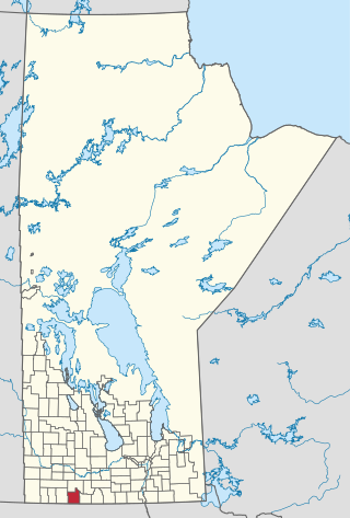
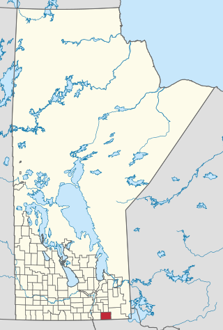
Killarney-Turtle Mountain is a rural municipality (RM) located in the Westman Region of Manitoba, Canada. It is located to the immediate north of the Canada–United States border opposite Rollete and Towner Counties, North Dakota.

North Shore is a rural municipality within Queens County in Prince Edward Island that was incorporated on September 28, 2018, through an amalgamation of three municipalities. The municipalities that amalgamated were the rural municipalities of Grand Tracadie, North Shore, and Pleasant Grove.

The Rural Municipality of Lakeshore is a rural municipality (RM) in the Parkland Region of Manitoba, Canada.
Central Prince is a rural municipality within Prince County in Prince Edward Island that was incorporated on September 28, 2018 through an amalgamation of two municipalities. The municipalities that amalgamated were the rural municipalities of Ellerslie-Bideford and Lady Slipper.