Rural Municipality of Cartier

Last updated

Cartier
Rural Municipality of Cartier
CAN MB Cartier.svg
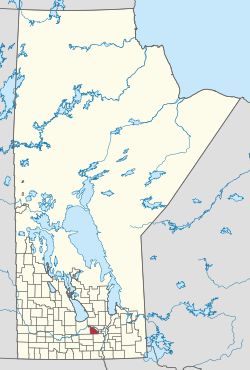
Location of Cartier in Manitoba
Coordinates: 49°53′10″N97°42′43″W / 49.886°N 97.712°W / 49.886; -97.712
Country Canada
Province Manitoba
Region Central Plains and Winnipeg Metro
IncorporatedFebruary 21, 1914
Named for George-Étienne Cartier
Government
  ReeveChrista Vann Mitchell [1]
Area
  Total552.94 km2 (213.49 sq mi)
Elevation
239 m (784 ft)
Population
 (2021) [2]
  Total3,344
  Density6.0/km2 (16/sq mi)
Time zone UTC−6 (CST)
  Summer (DST) UTC−5 (CDT)
Postal Code
R4K
Area codes 204, 431
Website rm-cartier.mb.ca

Rural Municipality of Cartier is a rural municipality in the Central Plains and Metro Regions of Manitoba, Canada. The municipality is bordered on the west by the RM of Portage la Prairie, to the east by the RM of Headingley, and to the north by the Assiniboine River. It is mainly flat rich farmland. Its main town is Elie.

Contents

It is named after Sir George-Étienne Cartier who was a leader in bringing Quebec into Confederation. Until 1914, it was part of the larger municipality of St. François Xavier.

Water

The Cartier Regional Water Co-op manages the water supply in the rural municipality as well as other nearby RMs such as Headingley, Rosser, and Macdonald. The Cartier Water Treatment Plant brings in water from the Assiniboine River where it is cleaned of silt and debris and other toxins and distributed within the RM and also sent out to other nearby communities. [3]

Communities

Demographics

In the 2021 Census of Population conducted by Statistics Canada, Cartier had a population of 3,344 living in 811 of its 850 total private dwellings, a change of

See also

Related Research Articles

<span class="mw-page-title-main">Rural Municipality of Rosser</span> Rural municipality in Manitoba, Canada

Rosser is a rural municipality (RM) in the Canadian province of Manitoba, lying adjacent to the northwest side of Winnipeg and part of the Winnipeg Metro Region. Its population as of the 2016 Census was 1,372.

<span class="mw-page-title-main">Rural Municipality of West St. Paul</span> Rural municipality in Manitoba

West St. Paul is a rural municipality (RM) in Manitoba, Canada. It lies adjacent to the north side of Winnipeg, and directly west of the Red River. It is part of the Winnipeg Metro Region, and had a population of 5,368 at the 2016 census.

<span class="mw-page-title-main">Rural Municipality of Dauphin</span> Rural municipality in Manitoba, Canada

Dauphin is a rural municipality in the Parkland Region of Manitoba, Canada. The municipality surrounds the separately administered city of Dauphin, and lies just north of Riding Mountain National Park, part of which extends into the RM.

<span class="mw-page-title-main">Rural Municipality of St. Andrews</span> Rural municipality in Manitoba, Canada

St. Andrews is a rural municipality (RM) in Manitoba, Canada. It lies west of the Red River; its southern border is approximately 8 kilometres (5.0 mi) north of Winnipeg.

<span class="mw-page-title-main">Rural Municipality of Headingley</span> Rural municipality in Manitoba, Canada

Headingley is a rural municipality in Manitoba, Canada. It is located directly west of Winnipeg and had a population of 3,579 people as of the 2016 census.

Elie is an unincorporated community recognized as a local urban district in the Rural Municipality of Cartier in the Canadian province of Manitoba.

<span class="mw-page-title-main">Rural Municipality of Macdonald</span> Rural Municipality in Southern Manitoba

Macdonald is a rural municipality lying adjacent to the southwest side of Winnipeg, Manitoba, Canada. It is part of the Winnipeg Metro Region, but is not part of the smaller Winnipeg census metropolitan area. Macdonald's population as of the 2016 census was 7,162.

<span class="mw-page-title-main">Rural Municipality of Rockwood</span> Rural Municipality in Manitoba, Canada

Rockwood is a rural municipality (RM) lying north of Winnipeg, Manitoba, Canada. It is part of the Winnipeg Metro Region and had a 2021 census population of 8,440. The independently governed towns of Stonewall and Teulon are both enclaved within Rockwood.

<span class="mw-page-title-main">Rural Municipality of St. François Xavier</span> Rural municipality in Manitoba, Canada

The Rural Municipality of St. François Xavier is a rural municipality (RM) in Manitoba, Canada, lying west-northwest of Winnipeg. It is part of the Central Plains Region as well as the Winnipeg Metro Region. It had a population of 1,411 in the 2016 census.

<span class="mw-page-title-main">Rural Municipality of Montmartre No. 126</span> Rural municipality in Saskatchewan, Canada

The Rural Municipality of Montmartre No. 126 is a rural municipality (RM) in the Canadian province of Saskatchewan within Census Division No. 6 and SARM Division No. 1. It is located in the southeast portion of the province along Highway 48.

<span class="mw-page-title-main">Rural Municipality of Sifton</span> Rural municipality in Manitoba, Canada

The Rural Municipality of Sifton is a rural municipality (RM) in the south-west portion of the Canadian province of Manitoba.

<span class="mw-page-title-main">Stony Mountain, Manitoba</span> Unincorporated Community in Manitoba, Canada

Stony Mountain is a small community in Manitoba, Canada approximately 11 kilometres (6.8 mi) north of Winnipeg on Provincial Highway 7. The town is in the Rural Municipality of Rockwood and is the location of Stony Mountain Ski Area. The Stony Mountain Institution and Rockwood Institution prisons are in Stony Mountain.

<span class="mw-page-title-main">Rural Municipality of Stanley</span> Rural municipality in Manitoba, Canada

Stanley is a rural municipality (RM) in the province of Manitoba in Western Canada. It is located in the southern part of the province, along its border with the state of North Dakota in the United States. Since 1876, the area made up part of the Mennonite West Reserve. The municipality has a population of 8,969 as of the 2016 Canada Census. The cities of Winkler and Morden lie geographically within the municipality but are separate urban municipalities.

<span class="mw-page-title-main">Rural Municipality of Morris</span> Rural municipality in Manitoba, Canada

Morris is a rural municipality (RM) in the province of Manitoba in Western Canada. The town of Morris, a separate urban municipality, is located in the southeastern corner of the RM.

<span class="mw-page-title-main">Rural Municipality of Mountain</span> Rural municipality in Manitoba, Canada

The Rural Municipality of Mountain is a rural municipality (RM) in the Parkland Region of Manitoba, western Canada.

<span class="mw-page-title-main">Rural Municipality of Stuartburn</span> Rural municipality in Manitoba, Canada

Stuartburn is a rural municipality (RM) located in the Eastman Region of Manitoba, Canada. It had a population of 1,629 according to the Canada 2006 Census.

St. François Xavier is an unincorporated urban centre located in the Rural Municipality of St. François Xavier, Manitoba, Canada. It is located about 15 km west of the city of Winnipeg on the Assiniboine River.

<span class="mw-page-title-main">Gilbert Plains Municipality</span> Rural municipality in Manitoba, Canada

Gilbert Plains Municipality is a rural municipality (RM) in the Canadian province of Manitoba.

<span class="mw-page-title-main">Riverdale Municipality</span> Rural municipality in Manitoba, Canada

Riverdale Municipality is a rural municipality (RM) in the Canadian province of Manitoba.

References

  1. "Reeve and Council".
  2. "2021 Census Profile - RM of Cartier". Statistics Canada . Retrieved March 30, 2023.
  3. "Cartier Regional Water Co-op: Public Water System: Annual Report 2018" (PDF). cwrc.ca. March 28, 2019. pp. 3–4, 7–8.
  4. "Population and dwelling counts: Canada, provinces and territories, and census subdivisions (municipalities), Manitoba". Statistics Canada. February 9, 2022. Retrieved February 20, 2022.