History
Historical population| Year | | |
|---|
| 1981 | 1,957 | — |
|---|
| 1986 | 2,039 | +4.2% |
|---|
| 1996 | 1,866 | −8.5% |
|---|
| 2001 | 1,905 | +2.1% |
|---|
| 2006 | 1,919 | +0.7% |
|---|
| 2011 | 1,835 | −4.4% |
|---|
| 2016 | 1,792 | −2.3% |
|---|
| 2021 | 1,967 | +9.8% |
|---|
The surrounding area was settled by immigrants from western Ukraine at the start of the 20th century. Amongst the original settlers were Michael Pomaransky and Stefan Humeny who settled section 14-19-2E, approximately ten miles west of the community of Gimli. A sizeable community developed as these settlers were joined in the year 1900 by other individuals from the village of Kopychentsi, Ukraine. [2]
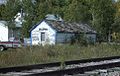
The hamlet of Kreuzberg received its first post office in 1910. [3]
The area was originally incorporated as three distinct rural municipalities, Armstrong, Kreuzberg and Chatfield, in 1913.
Incorporating much of the marginal farmland on the western edge of the Rural Municipality of Gimli, this area saw a number of schools built along the railway line that was constructed three years earlier. These were located in the hamlets of Malonton, Meleb, Rembrandt and Kreuzberg.
The hamlet of Kreuzburg was renamed Fraserwood during World War I, due to anti-German sentiments. Its name is derived from the surname of the postmaster at the time, Wood, and his wife's maiden name Fraser. The hamlet of Narcisse was named after Narcisse Leven, then the president of the Jewish Colonization Association (JCA or ICA), by the residents of Bender Hamlet, a Jewish farm colony located 2 km east of Narcisse.
During the Great Depression, the rural municipalities of Armstrong, Kreuzberg and Chatfield were dissolved, and were administered as the Local Government District of Armstrong. [4] The region was heavily affected by failure of the wheat crop in this era, resulting in one of the most serious poverty crises in all of Manitoba. [5]
On September 21, 1936 Lord Tweedsmuir, the Governor General of Canada, paid a visit to the region. When the school term opened, teacher Olga Uhryniuk received an official notice from the government that the Governor General was making a Canada-wide tour and that he planned to meet with the citizens of the hamlet of Fraserwood. Tweedsmuir visited the school and made an address to the students and numerous community members.
The local government district of Armstrong was subsequently reconstituted as a rural municipality in 1997.
The area is also home to the Narcisse Snake Dens, a provincial wildlife management area which is the world's largest known winter den for garter snakes.

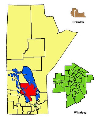
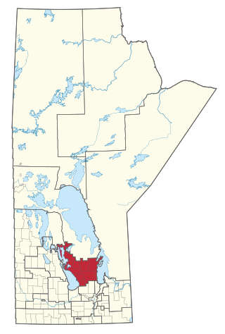
The Rural Municipality of Gimli is a rural municipality located in the Interlake Region of south-central Manitoba, Canada, on the western shore of Lake Winnipeg. It is about 75 kilometres (47 mi) north of the provincial capital Winnipeg. The rural municipality's population in the 2016 Canadian Census was 6,181, making it the 12th largest rural municipality by population. The RM of Gimli has an area of 318.75 km2 (123.07 sq mi), making it the sixth smallest rural municipality by area.
Interlake was a provincial electoral division in the Canadian province of Manitoba. It was created by redistribution in 1979, and has formally existed since the 1981 provincial election. Previously, much of the Interlake region was included in the constituency of St. George. As its name implies, Interlake was located between Lake Winnipeg and Lake Manitoba, in the mid-northern section of the province.

Gimli was a provincial electoral division in the Canadian province of Manitoba. It was created by redistribution in 1899, and existed continuously until the 2019 election. Following this, it was redistributed into the Interlake-Gimli electoral district.
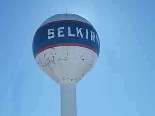
Selkirk is a city in the western Canadian province of Manitoba, located on the Red River about 22 kilometres (14 mi) northeast of Winnipeg, the provincial capital. It has a population of 10,504 as of the 2021 census.
Provincial Trunk Highway 7 is a provincial primary highway located in the Canadian province of Manitoba. It runs from the northern limit of the city of Winnipeg north to Arborg, Manitoba where it intersects with PTH 68. The highway is twinned from Winnipeg to just north of PTH 67, an east-west route that provides access to the Town of Stonewall.
Provincial Trunk Highway 17 is a provincial highway in the Canadian province of Manitoba. It runs from a junction with PR 224 and PR 325 near Hodgson to a junction with PTH 9 near Winnipeg Beach.

The Interlake Region is an informal geographic region of the Canadian province of Manitoba that lies roughly between Lake Winnipeg and Lake Manitoba in the Canadian province of Manitoba.
Arborg is a town located along the Icelandic River in Manitoba. The community is located 103 kilometres north of Winnipeg, at the junction of Manitoba Highways 7 and 68, in the Interlake Region of Manitoba, Canada. The town is surrounded by the Municipality of Bifrost - Riverton and has a population of 1,279 as of the 2021 Canadian census.

Winnipeg Beach is a town in the Interlake Region, in the Canadian province of Manitoba. The town was founded in 1900 by Sir William Whyte and is located at the junction of Highway 9 and Highway 229 on the southwestern shore of Lake Winnipeg, about 56 kilometres (35 mi) north of Winnipeg. It is bordered by the Rural Municipality of Gimli, the Rural Municipality of St. Andrews, and Dunnottar as well as Lake Winnipeg. Nearby towns are Ponemah, Whytewold, and Matlock, Gimli, and Sandy Hook,, as well as Teulon, and Selkirk. Its permanent population is 1,439

Teulon is a town located approximately 59 kilometres north of Winnipeg, Manitoba, Canada, on Provincial Trunk Highway 7. Located between Stonewall and Gimli, Teulon is commonly referred to as "The Gateway to the Interlake". Teulon is surrounded by the Rural Municipality of Rockwood.

Vita is a local urban district in southeast Manitoba settled by Ukrainian immigrants in the late 1890s. It is roughly 50 km (31 mi) by road from Steinbach in the Rural Municipality of Stuartburn.

Bender Hamlet, Manitoba was a Baron Maurice de Hirsch sponsored Jewish farm colony in the Rural Municipality of Armstrong, part of the Interlake region in the province of Manitoba. The centre of the settlement was located at quarter section North West 36Township 19, Range 1 west of the Principal Meridian (NW36-19-1W).

Census Division No. 18 is a census division located within the Interlake Region of the province of Manitoba, Canada. Unlike in some other provinces, census divisions do not reflect the organization of local government in Manitoba. These areas exist solely for the purposes of statistical analysis and presentation; they have no government of their own.
Michael Ewanchuk was a Ukrainian Canadian educator and historian. He held a Doctor of Law degree from the University of Winnipeg and a Doctor of Canon Law from St. John's College of the University of Manitoba. Ewanchuk was born in Gimli, Manitoba. He was raised by his parents, Paraskeva Ewanchuk & Wasyl Ewanchuk, he had 5 other siblings; Nettie Ewanchuk (Bohonos), Mary Ewanchuk, John Ewanchuk, Alexander Ewanchuk, and Peter Ewanchuk.

Gimli is an unincorporated community in the Rural Municipality of Gimli on the west side of Lake Winnipeg in Manitoba, Canada.

The Municipality of Bifrost-Riverton is a rural municipality (RM) in the Canadian province of Manitoba, and is one of the northernmost rural municipalities in the Interlake Region.
Hnausa Beach Provincial Park is a provincial park in Manitoba, Canada, on the west shore of Lake Winnipeg north of Gimli, Manitoba. The beach within the park is named after the nearby community of Hnausa. Hnausa is an Old Icelandic word for a piece of turf. This part of Manitoba is known as New Iceland due to the significant Icelandic settlement of the area that began in 1875.
Interlake-Gimli is a provincial electoral district in the Interlake region of Manitoba.

Provincial Road 231 is a 41.9-kilometre-long (26.0 mi) east–west highway in the Interlake Region of Manitoba, connecting the hamlets of Narcisse and Fraserwood with Gimli.