In the United States, an unorganized territory is a region of land without a "normally" constituted system of government. This does not mean that the territory has no government at all or that it is unclaimed territory. In practice, such territories are always sparsely populated.
The Opaskwayak Cree Nation is a First Nations band government in Manitoba, Canada. The First Nation has territory near The Pas along the Saskatchewan River. The First Nation hosts the Opaskwayak Indian Days annually each August. The OCN Blizzard, a Manitoba Junior Hockey League team, is based on the Indian reserve and plays out of the Gordon Lathlin Memorial Centre.
The Rural Municipality of Piney is a rural municipality in southeastern Manitoba, Canada, along the border with Minnesota in the United States. The population was 1,755 at the 2006 census.

Division No. 22, also informally known as Thompson-North Central, is a census division in the Canadian province of Manitoba.Located in Northern Region of Manitoba, and begins at the 53rd Parallel is known as Norman region denoting the start of Northern Manitoba.
Manitoba's Duck Mountain Provincial Forest is located in the western part of the province. The forest contains all of Duck Mountain Provincial Park, plus peripheral areas around it. The largest portion of the park and the forest are located in an unorganized portion of Census Division No. 20, but substantial portions of the forest lie in surrounding Rural Municipalities, including Ethelbert, Hillsburg, Grandview, Swan River, Minitonas, and Mountain.

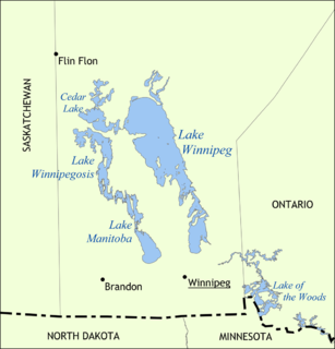
Division No. 1 is located in the Eastman Region of the Canadian province of Manitoba. It is located in the south-eastern corner of the province, lying between the Lake Winnipeg and Manitoba-Ontario border, and the Canada–US border. The Trans-Canada Highway runs through the Eastman Region. Also included in the division are the Buffalo Point First Nation and the Manitoba portion of the Shoal Lake 40 First Nation.

Census Division No. 20 - Swan River is part of the Parkland Region of the province of Manitoba. The population of the division in the 2006 census was 10,405. The economic bases of the region is mixed grain, livestock and forestry. It also includes all of Duck Mountain Provincial Park.
Census Division No. 17 Dauphin is part of the Parklands Region of the province of Manitoba, Canada. The economic base of the area is primarily agriculture with some manufacturing and food processing. The population of the division at the 2006 census was 22,358. The division is geographically centred on the city of Dauphin and Dauphin Lake, and contains most of Riding Mountain National Park. Also included in the division is the Ebb and Flow First Nation.This region in located in central Manitoba.
Division No. 1, Unorganized is a Statistics Canada census subdivision of its Division No. 1, Manitoba that consists of a part of the division that is not organized into either incorporated municipalities or Indian reserves. It is located at the southeast corner of Manitoba, along the border of both the Province of Ontario and the U.S. State of Minnesota. The northern half of the subdivision consists of Manitoba's Whiteshell Provincial Park. The 2006 Census reported a population of 1,130, a 68.66% increase from the 670 reported in the 2001 Census. Several Indian reserves are located within the territory of the southern portion, although they are not administratively a part of it. They include the Buffalo Point First Nation, Reed River 36A First Nation, Iskatewizaagegan 39 Independent First Nation, and Shoal Lake 40 First Nation Indian reserves.

Halcrow is a hamlet in northern Manitoba, Canada, about a mile east of Cormorant Lake on the eastern edge of the Cormorant Provincial Forest. It is in an unorganized area, one without incorporated municipalities or Indian reserves, in Division 21, Northern Region of Manitoba. Provincial Road 287 connects it to the west with Highway 10 with access to both Flin Flon to the north and The Pas to the south. Road 287 also connects it to the north with Cormorant Lake Airport about 12 kilometres (7 mi) by road. It is a flag stop on Via Rail's Winnipeg – Churchill rail line.
Manitoba's Porcupine Provincial Forest lies adjacent to the province's western border. The forest has an area of 2,090 km² and is located mostly in an unorganized part of Census Division No. 20, with small parts of it extending southward into the Rural Municipality of Swan River, and eastward into the Rural Municipality of Mountain, both of which are in the same census division.
Manitoba's Swan-Pelican Provincial Forest lies just west of Lake Winnipegosis, and is named for the two smaller lakes in the area, Swan Lake and Pelican Lake. The forest has an area of 3,705 km², and is the second-largest provincial forest in Manitoba. Most of the forest is located within the unorganized portion of Census Division No. 19, but its southernmost reaches extend into the Rural Municipality of Mountain (South). A fairly newly established forest, it was not officially recognized as a provincial forest until 1987.
Division No. 17, Unorganized is a Statistics Canada census subdivision of its Division No. 17, Manitoba that consists of a part of the division that is not organized into either incorporated municipalities or Indian reserves.
Unorganized West Division No. 18 is an unorganized area in central Manitoba, consisting of two non-contiguous areas. It includes the islands within Lake Manitoba and Lake St. Martin in Division No. 18 that are not a part of an organized municipality or First Nation. It has an area of 15.25 km2 and a recorded population of 0.
Division No. 19, Unorganized is an unorganized area spanning central Manitoba from east to west, and contains all of Division No. 19 except for First Nations reserves. It has a population of 2,953 as of 2011, and spans an area of 60,410.85 km2.
Division No. 21, Unorganized is an unorganized area in northwestern Manitoba. It consists of all of Division No. 21 excluding municipalities and reserves. It has a population of 1,756 as of 2011, and an area of 40,910.10 km2.
Division No. 20, Unorganized, North Part is an unorganized area in northwestern Manitoba. It has a population of 120 as of 2011, and an area of 1,760.53 km2.
Division No. 20, Unorganized, South Part is an unorganized area in northwestern Manitoba. It has a population of 82 as of 2011, and an area of 2,571.67 km2.
Division No. 22, Unorganized is an unorganized area in northeastern Manitoba. It consists of all of Division No. 22 excluding municipalities and reserves. It has a population of 2,205 as of 2011, and an area of 87,857.61 km2.
Division No. 23, Unorganized is an unorganized area in northern Manitoba. It consists of all of Division No. 23 excluding municipalities and reserves. It has a population of 171 as of 2006, and an area of 238,004.86 km2.