
Manitoba is a province of Canada at the longitudinal centre of the country. It is Canada's fifth-most populous province, with a population of 1,342,153 as of 2021. Manitoba has a widely varied landscape, from arctic tundra and the Hudson Bay coastline in the north to dense boreal forest, large freshwater lakes, and prairie grassland in the central and southern regions.

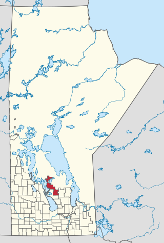
Lake Manitoba is the 14th largest lake in Canada and the 33rd largest lake in the world with a total area of 4,624 km2 (1,785 sq mi). It is located within the Canadian province of Manitoba about 75 km (47 mi) northwest of the province's capital, Winnipeg, at 50°59′N98°48′W.

An escarpment is a steep slope or long cliff that forms as a result of faulting or erosion and separates two relatively level areas having different elevations.

The Assiniboine River is a 1,070-kilometre (660 mi) river that runs through the prairies of Western Canada in Saskatchewan and Manitoba. It is a tributary of the Red River. The Assiniboine is a typical meandering river with a single main channel embanked within a flat, shallow valley in some places and a steep valley in others. Its main tributaries are the Qu'Appelle, Souris, and Whitesand Rivers. For early history and exploration see Assiniboine River fur trade.
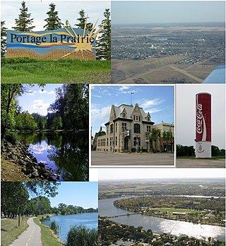
Portage la Prairie is a small city in the Central Plains Region of Manitoba, Canada. As of 2016, the population was 13,304 and the land area of the city was 24.68 square kilometres (9.53 sq mi).
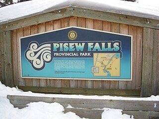
Pisew Falls Provincial Park is a provincial heritage park in the southwestern portion of Mystery Lake, Manitoba, Canada.

Niverville is a town in the Eastman Region, Manitoba, Canada. The town lies between the northwest corner of the Rural Municipality of Hanover and the southeastern portion of the Rural Municipality of Ritchot. Niverville's population as of the 2021 census is 5,947, the largest town and 10th-largest community in Manitoba.

Cartwright is an unincorporated urban community in the Cartwright – Roblin Municipality within the Canadian province of Manitoba that held village status prior to January 1, 2015. It was originally incorporated as a village on December 31, 1947.

In glaciology, a roche moutonnée is a rock formation created by the passing of a glacier. The passage of glacial ice over underlying bedrock often results in asymmetric erosional forms as a result of abrasion on the "stoss" (upstream) side of the rock and plucking on the "lee" (downstream) side. Some geologists limit the term to features on scales of a metre to several hundred metres and refer to larger features as crag and tail.
Provincial Trunk Highway 6 is a provincial primary highway located in the Canadian province of Manitoba. It runs from the Perimeter Highway of Winnipeg to the Thompson south city limits. It is also the main highway connecting Winnipeg to northern Manitoba. The speed limit is 100 km/h. The route is also used to deliver nickel from the Thompson mine to the Royal Canadian Mint in Winnipeg. The section of highway between its southern terminus near Winnipeg and the second junction with PTH 68 near Eriksdale is part of the Northern Woods and Water Route. The portion of the highway between Ponton and Thompson was known as Highway 391 prior to 1986.
Arborg is a town located along the Icelandic River in Manitoba. The community is located 103 kilometres north of Winnipeg, at the junction of Manitoba Highways 7 and 68, in the Interlake Region of Manitoba, Canada. The town is surrounded by the Municipality of Bifrost - Riverton and has a population of 1,279 as of the 2021 Canadian census.

Crystal City is an unincorporated community recognized as a local urban district in the Municipality of Louise within the Canadian province of Manitoba. It held village status prior to January 1, 2015. It is located on Highway 3, 16 kilometres north of the Canada–United States border and 200 kilometres southwest of Winnipeg.

Gladstone is an unincorporated urban community in the Municipality of WestLake – Gladstone within the Canadian province of Manitoba that held town status prior to January 1, 2015. It is located on the Yellowhead Highway at the intersection with Highway 34. The Gladstone railway station receives Via Rail service.

The history of Manitoba covers the period from the arrival of Paleo-Indians thousands of years ago to the present day. When European fur traders first travelled to the area present-day Manitoba, they developed trade networks with several First Nations. European fur traders in the area during the late-17th century, with the French under Pierre Gaultier de Varennes, sieur de La Vérendrye set up several trading post forts. In 1670, Britain declared sovereignty over the watershed of Hudson's Bay, known as Rupert's Land; with the Hudson's Bay Company granted a commercial monopoly over the territory.

Mather is an unincorporated community recognized as a local urban district in southwest Manitoba, Canada, and part of Cartwright – Roblin Municipality. The Mather area is known as Crocus Country.
Grahamdale is a rural municipality (RM) in the province of Manitoba in Western Canada. It lies in the Interlake Region. It was incorporated as a Local Government District (LGD) on 1 January 1945, and became a Rural Municipality in 1997.

Ste. Anne is a rural municipality (RM) in the Eastman Region of Manitoba, Canada, lying southeast of Winnipeg. The separately-administered town of Ste. Anne lies within the geographic borders of the municipality, in its northwestern part.

The Sapotaweyak Cree Nation is a First Nations band government whose reserves are located in northern Manitoba, north-east of Swan River, approximately 400 kilometres northwest of Winnipeg.

The Vendettas Motorcycle Club, or Vendettas Crew, is an International outlaw motorcycle club founded in Winnipeg, Manitoba, Canada in 2009. It was established by the more well-known Rock Machine Motorcycle Club (RMMC) to act as a support club throughout the Canadian province of Manitoba, but would grow to be an international support club of the RMMC with chapters in Canada, Australia, Russia, Sweden and Serbia.


