Rural Municipality of Alonsa

Last updated

Alonsa
Rural Municipality of Alonsa
CAN MB Alonsa.svg
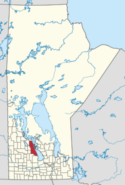
Location of Alonsa in Manitoba
Coordinates: 50°47′59″N98°58′36″W / 50.7996°N 98.9766°W / 50.7996; -98.9766
CountryCanada
Province Manitoba
Region Parkland
Incorporated as an LGD January 1, 1945
Incorporated as a rural municipalityJanuary 1, 1997
Government
   Reeve Tom Anderson [1]
  CouncillorsKerry Hopfner
Tim Stott
Travis Turko
Michael Brown
Terry Dayholos
Logan Dumanske
Area
  Total2,977.50 km2 (1,149.62 sq mi)
Population
 (2016) [2]
  Total1,247
Time zone UTC-6 (CST)
  Summer (DST) UTC-5 (CDT)
Website rmofalonsa.com

Alonsa is a rural municipality (RM) in the province of Manitoba, western Canada. It lies on the west side of Lake Manitoba. [2]

Contents

Located within the borders of the municipality is the Indian reserve of Ebb and Flow 52, as well as the 60,000 m2 (6 ha) Margaret Bruce Beach Provincial Park, located 12 km (7.5 mi) east of the town of Alonsa, on one of a series of sand ridges that extend the length of the west side lake. The park is currently under lease to a private operator but development plans include a provincial campground and day use facility. [3]

The incorporation of Alonsa on 1 January 1945 was as a Local Government District (LGD). It received rural municipality status on 1 January 1997.

Communities

Demographics

In the 2021 Census of Population conducted by Statistics Canada, Alonsa had a population of 1,210 living in 492 of its 659 total private dwellings, a change of

Related Research Articles

<span class="mw-page-title-main">Rural Municipality of Gimli</span> Rural municipality in Manitoba, Canada

The Rural Municipality of Gimli is a rural municipality located in the Interlake Region of south-central Manitoba, Canada, on the western shore of Lake Winnipeg. It is about 75 kilometres (47 mi) north of the provincial capital Winnipeg. The rural municipality's population in the 2016 Canadian Census was 6,181, making it the 12th largest rural municipality by population. The RM of Gimli has an area of 318.75 km2 (123.07 sq mi), making it the sixth smallest rural municipality by area.

<span class="mw-page-title-main">Lockport, Manitoba</span> Place in Manitoba, Canada

Lockport is a small unincorporated community in Manitoba, Canada. It is located 28 kilometres (17 mi) north of the city of Winnipeg along the Red River. The community is split between the Rural Municipalities of St. Andrews and St. Clements.

<span class="mw-page-title-main">Rural Municipality of St. Clements</span> Rural municipality in Manitoba, Canada

St. Clements is a rural municipality (RM) in Manitoba, Canada. It is located to the north-east of Winnipeg, stretching from East St. Paul and Birds Hill Provincial Park in the south to Lake Winnipeg and Grand Beach Provincial Park to the north. The Red River demarcates the western boundary of the municipality. St. Clements contains the communities of East Selkirk, and Lockport east of the Red River. It almost completely surrounds the Brokenhead 4 Indian reserve, with the exception of a small lakefront on Lake Winnipeg.

<span class="mw-page-title-main">Rural Municipality of Dundurn No. 314</span> Rural municipality in Saskatchewan, Canada

The Rural Municipality of Dundurn No. 314 is a rural municipality (RM) in the Canadian province of Saskatchewan within Census Division No. 11 and SARM Division No. 5. It is located in the north-central portion of the province along the South Saskatchewan River and surrounds the Town of Dundurn.

<span class="mw-page-title-main">Rural Municipality of Reynolds</span> Rural municipality in Manitoba, Canada

The Rural Municipality of Reynolds is a rural municipality (RM) in southeastern Manitoba, Canada.

<span class="mw-page-title-main">Rural Municipality of Springfield</span> Rural municipality in Manitoba, Canada

Springfield is a rural municipality (RM) in Manitoba, Canada. It stretches from urban industrial development on the eastern boundary of the city of Winnipeg, through urban, rural residential, agricultural and natural landscapes, to the Agassiz Provincial Forest on the municipality's eastern boundary. Birds Hill Provincial Park nestles into the north-western corner of Springfield.

<span class="mw-page-title-main">Rural Municipality of Frenchman Butte No. 501</span> Rural municipality in Saskatchewan, Canada

The Rural Municipality of Frenchman Butte No. 501 is a rural municipality (RM) in the Canadian province of Saskatchewan within Census Division No. 17 and SARM Division No. 6.

<span class="mw-page-title-main">Rural Municipality of Victoria</span> Rural municipality in Manitoba, Canada

The Rural Municipality of Victoria is a rural municipality (RM) located in south-central Manitoba, north-east of Glenboro. The RM was established in 1902 and named for Queen Victoria. In its westernmost part, the RM contains parts of Manitoba's Spruce Woods Provincial Forest and Spruce Woods Provincial Park.

<span class="mw-page-title-main">Rural Municipality of Sifton</span> Rural municipality in Manitoba, Canada

The Rural Municipality of Sifton is a rural municipality (RM) in the south-west portion of the Canadian province of Manitoba.

<span class="mw-page-title-main">Rural Municipality of Lac du Bonnet</span> Rural municipality in Manitoba, Canada

Lac du Bonnet is a rural municipality in the province of Manitoba in Western Canada, situated between the Nopiming Provincial Park to the northeast and Whiteshell Provincial Park to the southeast.

<span class="mw-page-title-main">Rural Municipality of Mountain</span> Rural municipality in Manitoba, Canada

The Rural Municipality of Mountain is a rural municipality (RM) in the Parkland Region of Manitoba, western Canada.

<span class="mw-page-title-main">Municipality of Killarney-Turtle Mountain</span> Rural municipality in Manitoba, Canada

Killarney-Turtle Mountain is a rural municipality (RM) located in the Westman Region of Manitoba, Canada. It is located to the immediate north of the Canada–United States border opposite Rollete and Towner Counties, North Dakota.

<span class="mw-page-title-main">Rural Municipality of Moose Mountain No. 63</span> Rural municipality in Saskatchewan, Canada

The Rural Municipality of Moose Mountain No. 63 is a rural municipality (RM) in the Canadian province of Saskatchewan within Census Division No. 1 and SARM Division No. 1. It is located in the south-east portion of the province.

<span class="mw-page-title-main">Rural Municipality of Big River No. 555</span> Rural municipality in Saskatchewan, Canada

The Rural Municipality of Big River No. 555 is a rural municipality (RM) in the Canadian province of Saskatchewan within Census Division No. 16 and SARM Division No. 5.

<span class="mw-page-title-main">Rural Municipality of Duck Lake No. 463</span> Rural municipality in Saskatchewan, Canada

The Rural Municipality of Duck Lake No. 463 is a rural municipality (RM) in the Canadian province of Saskatchewan within Census Division No. 15 and SARM Division No. 5.

<span class="mw-page-title-main">Rural Municipality of Loon Lake No. 561</span> Rural municipality in Saskatchewan, Canada

The Rural Municipality of Loon Lake No. 561 is a rural municipality (RM) in the Canadian province of Saskatchewan within Census Division No. 17 and SARM Division No. 6.

<span class="mw-page-title-main">Cartwright-Roblin Municipality</span> Rural municipality in Manitoba, Canada

Cartwright–Roblin Municipality is a rural municipality in the Canadian province of Manitoba.

<span class="mw-page-title-main">Rural Municipality of Lakeshore</span> Rural municipality in Manitoba, Canada

The Rural Municipality of Lakeshore is a rural municipality (RM) in the Parkland Region of Manitoba, Canada.

<span class="mw-page-title-main">Rural Municipality of Riding Mountain West</span> Rural municipality in Manitoba, Canada

The Rural Municipality of Riding Mountain West is a rural municipality (RM) in the Canadian province of Manitoba. It is located in Manitoba's Parkland region, between Riding Mountain National Park near the province's western border with Saskatchewan.

References

  1. "Members". April 22, 2017.
  2. 1 2 "Manitoba Communities: Alonsa (Rural Municipality)".
  3. Margaret Bruce Recreation Parks, Planning Section 3, Gov of Manitoba Conservation
  4. "Population and dwelling counts: Canada, provinces and territories, and census subdivisions (municipalities), Manitoba". Statistics Canada. February 9, 2022. Retrieved February 20, 2022.