Virden, Manitoba

Last updated

Virden
Town of Virden
Virden Pioneer Home Museum.JPG
Virden Pioneer Home Museum
461 Virden, Manitoba.svg
Town boundaries
Canada Manitoba location map 2.svg
Red pog.svg
Virden
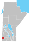
Location in Manitoba
Coordinates: 49°51′03″N100°55′54″W / 49.85083°N 100.93167°W / 49.85083; -100.93167
CountryCanada
Province Manitoba
Government
  MayorTina Williams
  MLA Doyle Piwniuk (PC)
  MP Larry Maguire (C)
Area
  Total8.96 km2 (3.46 sq mi)
Elevation

(at airport)
439 m (1,440 ft)
Population
 (2021) [1]
  Total3,118
  Density350/km2 (900/sq mi)
Time zone UTC−5 (CST)
Postal code
R0M 2C0
Area code(s) 204, 431
Telephone Exchange 204 491 512 707 718 748 851 431 645
Median Income$46,604
Website www.virden.ca

Virden is a town in southwestern Manitoba, Canada. Oil was first discovered in 1951, and Virden has since come to be known as the "Oil Capital of Manitoba".

Contents

History

Virden has its roots as a farming community known as Gopher Creek. However, it became a railway tent town in 1882, and grew in population due to the brick and flour industry, as well as with the discovery of oil in the 1950s. The origin of the name, Virden, allegedly arose as a misspelling of the German town Verden in the homeland of the 7th Duke of Manchester's wife, Louisa Cavendish, Duchess of Devonshire.

Geography

The town is located at the junction of the Trans-Canada Highway (also known as Highway #1) and Highway 83 (the "Palms to Pines" route) and is surrounded by the Rural Municipality of Wallace – Woodworth. Virden is a regional service centre owing in part to its location, and it has a stable commercial sector, including several restaurants, gas stations, body shops, a movie theatre, and a performing arts theatre.

Climate

Climate data for Virden
MonthJanFebMarAprMayJunJulAugSepOctNovDecYear
Record high °C (°F)9.7
(49.5)
17
(63)
20
(68)
36
(97)
37
(99)
42.8
(109.0)
43.3
(109.9)
38.5
(101.3)
37.8
(100.0)
34
(93)
23.5
(74.3)
12.8
(55.0)
43.3
(109.9)
Mean daily maximum °C (°F)−11.5
(11.3)
−7.1
(19.2)
−0.3
(31.5)
10.5
(50.9)
18.7
(65.7)
22.8
(73.0)
25.5
(77.9)
24.6
(76.3)
18.2
(64.8)
11.1
(52.0)
−0.6
(30.9)
−8.9
(16.0)
8.6
(47.5)
Daily mean °C (°F)−16.7
(1.9)
−12.2
(10.0)
−5.3
(22.5)
4.2
(39.6)
11.9
(53.4)
16.6
(61.9)
19
(66)
18
(64)
11.9
(53.4)
5.2
(41.4)
−5.1
(22.8)
−13.7
(7.3)
2.8
(37.0)
Mean daily minimum °C (°F)−21.9
(−7.4)
−17.3
(0.9)
−10.2
(13.6)
−2.1
(28.2)
5.1
(41.2)
10.3
(50.5)
12.6
(54.7)
11.3
(52.3)
5.6
(42.1)
−0.8
(30.6)
−9.6
(14.7)
−14.6
(5.7)
−3
(27)
Record low °C (°F)−42.2
(−44.0)
−44.4
(−47.9)
−43.3
(−45.9)
−26.7
(−16.1)
−12.2
(10.0)
−2.2
(28.0)
0
(32)
−4.4
(24.1)
−10
(14)
−21
(−6)
−38.9
(−38.0)
−40
(−40)
−44.4
(−47.9)
Average precipitation mm (inches)21.3
(0.84)
17
(0.7)
26.7
(1.05)
30.1
(1.19)
49.6
(1.95)
77.2
(3.04)
66.1
(2.60)
61
(2.4)
49.7
(1.96)
30.9
(1.22)
22.7
(0.89)
22.1
(0.87)
474.3
(18.67)
Source: Environment Canada [2]

Demographics

Historical population
YearPop.±%
1901901    
19111,550+72.0%
19211,361−12.2%
19311,590+16.8%
19411,619+1.8%
19511,746+7.8%
19612,708+55.1%
1996 3,137+15.8%
2001 3,109−0.9%
2006 3,010−3.2%
2011 3,114+3.5%
2016 3,322+6.7%
2021 3,118−6.1%
[3] [4] [5] [1] [6]

In the 2021 Census of Population conducted by Statistics Canada, Virden had a population of 3,118 living in 1,401 of its 1,508 total private dwellings, a change of

In 2011, the median age was 42.7 years old which is 2 years older than the national average at 40.6 years old. There were 1,446 dwellings in Virden with an occupancy rate of 95.1%, and the median cost of a dwelling at $159,748, more than $100,000 lower than the national average at $280,552.

According to the 2011 National Household Survey, 96.8% of Virden residents are Canadian citizens, and about 3.2% of residents are recent immigrants (from 2001 to 2011). The racial make up of Virden is mostly Caucasian (92.0%), with a moderate Aboriginal population (5.5%); First Nations (2.0%), Métis (3.5%), and a small visible minority population (2.7%), most of which are Filipino (2.0%) or multiracial (0.5%).

Attractions

Virden Pioneer Home Museum

Known as the "Victorian Home on the Prairies", the Virden Pioneer Home Museum is located within a red brick veneer home built by James Frame in 1888. With an extensive collection of over eleven thousand donated artifacts relating to Virden and area, the museum is a must-see tourist destination. It is open May to September where guided tours are offered by knowledgeable guides. The museum is located at 390 King Street West in Virden.

Notable people

See also

Related Research Articles

<span class="mw-page-title-main">Grande Prairie</span> City in Alberta, Canada

Grande Prairie is a city in northwest Alberta, Canada within the southern portion of an area known as Peace River Country. It is located at the intersection of Highway 43 and Highway 40, approximately 456 km (283 mi) northwest of Edmonton. The city is surrounded by the County of Grande Prairie No. 1.

<span class="mw-page-title-main">Black Diamond, Alberta</span> Former town in Alberta, Canada

Black Diamond is a former town in the Calgary Metropolitan Region of Alberta, Canada within the Town of Diamond Valley. It is at the intersection of Highway 22 and Highway 7. Its first post office opened in 1907. Black Diamond was so named because of coal deposits near the original town site. Little oil or gas remains.

<span class="mw-page-title-main">Drumheller</span> Town in Alberta, Canada

Drumheller is a town on the Red Deer River in the badlands of east-central Alberta, Canada. It is located 110 kilometres (68 mi) northeast of Calgary and 97 kilometres (60 mi) south of Stettler. The Drumheller portion of the Red Deer River valley, often referred to as Dinosaur Valley, has an approximate width of 2 kilometres (1.2 mi) and an approximate length of 28 kilometres (17 mi).

<span class="mw-page-title-main">Redvers, Saskatchewan</span> Town in Saskatchewan, Canada

Redvers is a town in southeast Saskatchewan, Canada. It is the first town when travelling west from Manitoba on the Red Coat Trail, the path taken by the North-West Mounted Police on their March West in 1874, and now modern Highway 13. A statue of a Mountie on a horse can be seen just west of the intersection of Highway 13 and Highway 8.

<span class="mw-page-title-main">Castor, Alberta</span> Town in Alberta, Canada

Castor is a town in Alberta, Canada. It is located at the intersection of Highway 12 and Highway 861, approximately 143 km (89 mi) east of the City of Red Deer. It has an elevation 816 m (2,677 ft).

Redcliff is a town in southern Alberta, Canada. Adjacent to the City of Medicine Hat to the east and Cypress County to the west and north, the town is bisected by Highway 1 and is located on the north bank of the South Saskatchewan River.

<span class="mw-page-title-main">Oyen</span> Town in Alberta, Canada

Oyen is a town in east-central Alberta, Canada near the Saskatchewan boundary and north of Medicine Hat. It is on Highway 41, 4 km (2.5 mi) south of its junction with Highway 9.

<span class="mw-page-title-main">Viking, Alberta</span> Town in Alberta, Canada

Viking is a town in central Alberta, Canada. It is at the intersection of Highway 14 and Highway 36, approximately 121 km (75 mi) east of Edmonton.

Zama City is a hamlet in northwestern Alberta, Canada within Mackenzie County.

<span class="mw-page-title-main">Fox Creek, Alberta</span> Town in Alberta, Canada

Fox Creek is a town in northwest Alberta, Canada. It is located on Highway 43, approximately 259 km (161 mi) northwest of Edmonton and 199 km (124 mi) southeast of Grande Prairie, and has an elevation of 808 m (2,651 ft).

<span class="mw-page-title-main">Spirit River, Alberta</span> Town in Alberta, Canada

Spirit River is a town in northern Alberta, Canada. It is approximately 78 km (48 mi) north of Grande Prairie at the junction of Highway 49 and Highway 731.

<span class="mw-page-title-main">Valleyview, Alberta</span> Town in Alberta, Canada

Valleyview is a town in northwest Alberta, Canada. It is surrounded by the Municipal District of Greenview No. 16 and in Census Division No. 18.

<span class="mw-page-title-main">Elkhorn, Manitoba</span> Place in Manitoba, Canada

Elkhorn is an unincorporated community recognized as a local urban district in the Rural Municipality of Wallace – Woodworth within the Canadian province of Manitoba that held village status prior to January 1, 2015. It was originally incorporated as a village on January 2, 1906. Elkhorn is located approximately 105 kilometres (65 mi) west of Brandon.

<span class="mw-page-title-main">Nampa, Alberta</span> Village in Alberta, Canada

Nampa is a village in northern Alberta, Canada. It is 27 km (17 mi) south of the Town of Peace River on Highway 2. Heart River crosses the Highway 2 just north of community. Canadian National Railway owned railway traverses the village. Nampa is an Indigenous word for 'the Place'.

<span class="mw-page-title-main">Municipal District of Greenview No. 16</span> Municipal district in Alberta, Canada

The Municipal District of Greenview No. 16 is a municipal district (MD) in northwest Alberta, Canada. It covers the full extent of Census Division 18, and with an area of 32,984 km2 (12,735 sq mi), it is the largest municipal district in Alberta. Its administrative office is located in the Town of Valleyview.

<span class="mw-page-title-main">Oak Lake, Manitoba</span> Place in Manitoba, Canada

Oak Lake is an unincorporated urban community in the Rural Municipality of Sifton within the Canadian province of Manitoba that held town status prior to January 1, 2015. It is located 52 km (32 mi) west of Brandon along the Trans-Canada Highway. The lake after which it was named is in the rural municipality's western area.

<span class="mw-page-title-main">Waskada</span> Former village in Manitoba, Canada

Waskada is an unincorporated urban community in the Municipality of Brenda – Waskada within the Canadian province of Manitoba that held village status prior to January 1, 2015. It is located in the southwest corner of the province, close to the United States and Saskatchewan borders. It was settled as early as 1883 and incorporated as a village in 1948. Waskada has a population of 183, and covers a land area of 0.77 km2. Though traditionally a farming community, a recent oil boom has also brought economic activity to the area.

<span class="mw-page-title-main">Gainsborough, Saskatchewan</span> Village in Saskatchewan, Canada

Gainsborough is a village in the Canadian province of Saskatchewan within the Rural Municipality of Argyle No. 1 and Census Division No. 1. A farming community, the village is located on Highway 18 in the southeastern corner of Saskatchewan. Gainsborough is approximately 6 km (3.7 mi) from the Manitoba border, and 19 km (12 mi) from the North Dakota, United States border. The first post office was established on April 1, 1884 as the community of Antler. On September 1, 1885, the name of the community changed to Gainsborough, after Gainsborough, Lincolnshire in England, which was the former home of J. J. Sadler, an early settler.

<span class="mw-page-title-main">Division No. 6, Manitoba</span> Census division in Manitoba, Canada

Division No. 6 (Virden) is a census division located within the Westman Region of south west Manitoba, Canada. Unlike in some other provinces, census divisions do not reflect the organization of local government in Manitoba. These areas exist solely for the purposes of statistical analysis and presentation; they have no government of their own.

Shoal Lake is a locality in the southwest of Manitoba, Canada. Originally incorporated as a town, Shoal Lake amalgamated with the Rural Municipality of Shoal Lake on January 1, 2011 to form the Municipality of Shoal Lake, which became the Rural Municipality of Yellowhead on January 1, 2015.

References

  1. 1 2 3 "Population and dwelling counts: Canada, provinces and territories, and census subdivisions (municipalities), Manitoba". Statistics Canada. February 9, 2022. Retrieved February 20, 2022.
  2. Environment Canada Canadian Climate Normals 1971–2000, accessed 18 May 2010
  3. "Canada Year Book 1932" (PDF). Archived from the original (PDF) on October 19, 2014. Retrieved August 30, 2014., Censuses 1871–1931
  4. "Canada Year Book 1955" (PDF). Archived (PDF) from the original on December 9, 2013. Retrieved August 30, 2014., Census 1941–1951
  5. Canada, Statistics (March 31, 2008). "Canada Year Book (CYB) Historical Collection" (PDF). www66.statcan.gc.ca. Retrieved July 30, 2023.
  6. "Census Profile. 2016 Census. Statistics Canada Catalogue no. 98-316-X2016001". Ottawa: Statistics Canada. October 25, 2017. Retrieved June 24, 2018.