Butler | |
|---|---|
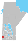
Location of Butler in Manitoba | |
| Coordinates: 49°47′43″N101°21′38″W / 49.79528°N 101.36056°W | |
| Country | |
| Province | |
| Region | Westman Region |
| Census Division | No. 6 |
| Government | |
| • Governing Body | Rural Municipality of Pipestone Council |
| • MP | Grant Jackson |
| • MLA | Greg Nesbitt |
| Time zone | UTC−6 (CST) |
| • Summer (DST) | UTC−5 (CDT) |
| Area codes | 204, 431 |
| NTS Map | 062F14 |
| GNBC Code | GAEBC |
Butler is an unincorporated community located within the Rural Municipality of Pipestone in southwestern Manitoba, Canada. It is located approximately 31 kilometres (19 miles) southwest of Virden, Manitoba. [1]

