The name of the community was derived from the area where many of the original settlers came from, which was Reston Junction in Berwickshire, Scotland. The post office opened in 1890 on land location 9-7-27W. It was also a Canadian Pacific railway point and there was a school district which had the name Lanark and a district named Reston was later located on 9-7-27W.
In October 2012, Reston sold lots in the community for $10 in order to attract families and businesses.[3][4]
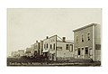
Main Street, 1909
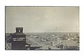
Reston, c. 1920
Demographics
In the 2021 Census of Population conducted by Statistics Canada, Reston had a population of 659 living in 305 of its 336 total private dwellings, a change of 15.8% from its 2016 population of 569. With a land area of 5.32km2 (2.05sqmi), it had a population density of 123.9/km2 (320.8/sqmi) in 2021.[5]
Arts and culture
Reston was featured during season 3 of the CBC program Still Standing.[6] The episode originally aired on August 8, 2017.
This page is based on this Wikipedia article Text is available under the CC BY-SA 4.0 license; additional terms may apply. Images, videos and audio are available under their respective licenses.