The Westman Region is an informal geographic region of the Canadian province of Manitoba located in the southwestern corner of the province.

Virden is a town in southwestern Manitoba, Canada. Oil was first discovered in 1951, and Virden has since come to be known as the "Oil Capital of Manitoba".

Coutts is a village in southern Alberta, Canada that is a port of entry into the U.S. state of Montana. It is one of the busiest ports of entry on the Canada–United States border in western Canada. It connects Highway 4 to Interstate 15, an important trade route between Alberta, American states along I-15, and Mexico.

Oak Lake is an unincorporated urban community in the Rural Municipality of Sifton within the Canadian province of Manitoba that held town status prior to January 1, 2015. It is located 52 km (32 mi) west of Brandon along the Trans-Canada Highway. The lake after which it was named is in the rural municipality's western area.

Pipestone, Manitoba is a community in southwestern Manitoba located in the unceded territory of the Dakota people in Treaty 2. The Dakota have never signed a treaty in Canada.

Waskada is an unincorporated urban community in the Municipality of Brenda – Waskada within the Canadian province of Manitoba that held village status prior to January 1, 2015. It is located in the southwest corner of the province, close to the United States and Saskatchewan borders. It was settled as early as 1883 and incorporated as a village in 1948. Waskada has a population of 183, and covers a land area of 0.77 km2. Though traditionally a farming community, a recent oil boom has also brought economic activity to the area.

Gainsborough is a village in the Canadian province of Saskatchewan within the Rural Municipality of Argyle No. 1 and Census Division No. 1. A farming community, the village is located on Highway 18 in the southeastern corner of Saskatchewan. Gainsborough is approximately 6 km (3.7 mi) from the Manitoba border, and 19 km (12 mi) from the North Dakota, United States border. The first post office was established on April 1, 1884 as the community of Antler. On September 1, 1885 the name of the community changed to Gainsborough, after Gainsborough, Lincolnshire in England, which was the former home of J. J. Sadler, an early settler.

Division No. 5 is a census division located within the Westman Region in the south west area of the province of Manitoba, Canada. Unlike in some other provinces, census divisions do not reflect the organization of local government in Manitoba. These areas exist solely for the purposes of statistical analysis and presentation; they have no government of their own.
Division No. 7 is a census division located within the Westman Region in the south western area of the province of Manitoba, Canada. Unlike in some other provinces, census divisions do not reflect the organization of local government in Manitoba. These areas exist solely for the purposes of statistical analysis and presentation; they have no government of their own.
Census Division No. 9 is a census division located within the Central Plains Region of the Province of Manitoba, Canada. Unlike in some other provinces, census divisions do not reflect the organization of local government in Manitoba. These areas exist solely for the purposes of statistical analysis and presentation; they have no government of their own.
Census Division No. 15 is a census division located within the Westman Region of the province of Manitoba, Canada. Unlike in some other provinces, census divisions do not reflect the organization of local government in Manitoba. These areas exist solely for the purposes of statistical analysis and presentation; they have no government of their own.

Pipestone is a rural municipality in the southwestern part of the province of Manitoba in Western Canada
Portage la Prairie is a rural municipality in the province of Manitoba in Western Canada. It surrounds the city of Portage la Prairie, Manitoba's fifth-largest city. Also within the borders of the municipality are the Dakota Plains First Nation and most of the Long Plain First Nation Indian reserves.
Killarney-Turtle Mountain is a rural municipality (RM) located in the Westman Region of Manitoba, Canada. It is located to the immediate north of the Canada–United States border opposite Rollete and Towner Counties, North Dakota.
Sioux Valley Dakota Nation (SVDN) or Wipazoka Wakpa is a Dakota (Sioux) First Nation that resides west of Brandon, Manitoba.
The Canupawakpa Dakota First Nation or Chanupa Wakpa is a First Nations in western Manitoba, located on Oak Lake Reserve - 59A.
The Prairie Mountain Health is the governing body responsible for healthcare delivery and regulation for the eponymous health region in southwest Manitoba.

The Municipality of Boissevain – Morton is a rural municipality (RM) in the Westman Region of the Canadian province of Manitoba.
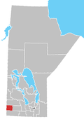
The Municipality of Two Borders is a rural municipality (RM) in the Canadian province of Manitoba. It is located in the extreme south-west corner of the province in the Westman Region.