Grunthal is a local urban district in the Rural Municipality of Hanover, Manitoba, located 24 kilometers southwest of Steinbach, and about 50 minutes south of Winnipeg. It had a population of 1,680 in 2016.
Roblin is an unincorporated urban community in the Municipality of Roblin, Manitoba, Canada. It is located approximately 400 km (250 mi) northwest of Winnipeg.
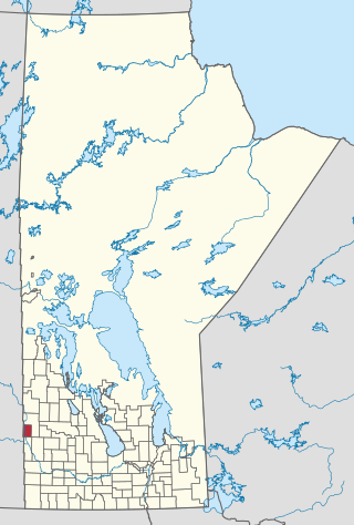
The Waywayseecappo First Nation is a First Nations band government whose reserve is located twenty miles east of Russell, Manitoba, Canada. The First Nation's reserve is 10,059 hectare and is located near the southwestern corner of the Riding Mountain National Park. It is bordered by the Rural Municipality of Rossburn and the Rural Municipality of Riding Mountain West. The First Nation also hold interest together with 32 other First Nations on the 37.1 hectare Treaty Four Reserve Grounds , located adjacent to Fort Qu'Appelle. Its population was 1,219 in 2011. They are home of the MJHL team Waywayseecappo Wolverines. There are several businesses located in the Birdtail valley near PTH 45, such as a gas station, food mart, gaming centre, health centre, daycare, and community arena complex. As of April 1, 2014, the RCMP is no longer in the community, being replaced by the Manitoba First Nations Police Service.

Parkland is an informal geographic region of the Canadian province of Manitoba, located between Lakes Manitoba and Winnipegosis on the east and the Manitoba–Saskatchewan border on the west.

Binscarth is an unincorporated urban community in the Municipality of Russell – Binscarth, Manitoba. It is located approximately 167 km (104 mi) northwest of Brandon, 16 km (9.9 mi) south from Russell, and 16 km (10 mi) east of the Saskatchewan border.

Togo is a village in the Canadian province of Saskatchewan within the Rural Municipality of Cote No. 271 and Census Division No. 9. It is 800 metres west of the Manitoba border and approximately 72 km (45 mi) northeast of the city of Yorkton.
Rossburn is an unincorporated urban community in the Rossburn Municipality, Manitoba. Prior to 1 January 2015, Rossburn was designated as a town. It is near Waywayseecappo First Nation. There is an elementary school and a high school.

Division No. 4 is a census division located within the Pembina Valley Region in the south-central region of the province of Manitoba, Canada. Unlike in some other provinces, census divisions do not reflect the organization of local government in Manitoba. These areas exist solely for the purposes of statistical analysis and presentation; they have no government of their own.
Division No. 6 (Virden) is a census division located within the Westman Region of south west Manitoba, Canada. Unlike in some other provinces, census divisions do not reflect the organization of local government in Manitoba. These areas exist solely for the purposes of statistical analysis and presentation; they have no government of their own.
Census Division No. 8 is a census division located within the Central Plains Region of the Province of Manitoba, Canada. Unlike in some other provinces, census divisions do not reflect the organization of local government in Manitoba. These areas exist solely for the purposes of statistical analysis and presentation; they have no government of their own.
Census Division No. 15 is a census division located within the Westman Region of the province of Manitoba, Canada. Unlike in some other provinces, census divisions do not reflect the organization of local government in Manitoba. These areas exist solely for the purposes of statistical analysis and presentation; they have no government of their own.
Census Division No. 18 is a census division located within the Interlake Region of the province of Manitoba, Canada. Unlike in some other provinces, census divisions do not reflect the organization of local government in Manitoba. These areas exist solely for the purposes of statistical analysis and presentation; they have no government of their own.
The Rural Municipality of Russell is a former rural municipality (RM) in the Canadian province of Manitoba. It was originally incorporated as a rural municipality on August 15, 1881. It ceased on January 1, 2015, as a result of its provincially mandated amalgamation with the Town of Russell and the Village of Binscarth to form the Municipality of Russell – Binscarth.
Provincial Trunk Highway 45 is a provincial highway in the Parkland Region of the Canadian province of Manitoba. It runs from PTH 16 and PTH 83 in the town of Russell to PTH 10 five kilometres (3.1 mi) north of the village of Erickson.

Cartwright–Roblin Municipality is a rural municipality in the Canadian province of Manitoba.

The Municipality of Roblin is located in western Manitoba, within the Parkland region, near the border with Saskatchewan. It encompasses a mix of rural landscapes, agricultural land, and small urban areas. The municipality serves as a hub for nearby communities, offering essential services, schools, and infrastructure that support residents and surrounding areas.

Rossburn Municipality is a rural municipality (RM) in the Parkland Region of Manitoba, Canada.
The Municipality of Russell – Binscarth is a rural municipality (RM) in the Parkland Region of Manitoba, Canada. It is located in the far western part of the province and shares a border with the neighbouring province of Saskatchewan.

Provincial Road 359 (PR 359) is a 35.9-kilometre-long (22.3 mi) east–west gravel road in the Parkland Region of Manitoba, connecting Binscarth with Rossburn.


