Weyburn is the tenth-largest city in Saskatchewan, Canada. The city has a population of 11,019. It is on the Souris River 110 kilometres (68 mi) southeast of the provincial capital of Regina and is 70 kilometres (43 mi) north from the North Dakota border in the United States. The name is reputedly a corruption of the Scottish "wee burn," referring to a small creek. The city is surrounded by the Rural Municipality of Weyburn No. 67.

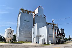
Hamiota is an unincorporated urban community in the Hamiota Municipality within the Canadian province of Manitoba that held town status prior to January 1, 2015. It is located on Provincial Trunk Highway 21 midway between the Trans-Canada Highway and the Yellowhead Highway. It is located in Western Manitoba, 84 kilometers northwest of Brandon. The trading area radius of 20 kilometres has approximately 10,000 people. First known as Hamilton, for Thomas Hamilton, one of the first settlers, the town name was changed to avoid confusion with Hamilton, Ontario. The new name contracted Hamilton with the Sioux word ota, "much".
Souris is an unincorporated urban community in the Municipality of Souris – Glenwood within the Canadian province of Manitoba that held town status prior to January 1, 2015. It is located within the municipality at the confluence of Plum Creek and Souris River, from which it takes its name. Before 1882, the town was called Plum Creek. The community is home to Canada's longest historic cable-stayed footbridge at 177 metres (581 ft) long, known as the Swinging Bridge, which spans the Souris River that divides the community. The Swinging Bridge was built in 1904 as a means of transportation over the Souris River, later floods destroyed the original swinging bridge and in 2013 a modern cable bridge was installed. Residents of Souris are referred to as Sourisites.

Melita is a town located in the south-western corner of the Canadian province of Manitoba. It is surrounded by the Municipality of Two Borders and occupies a bend of the Souris River. Graham Creek runs along the west side of town and into the Souris River. The population at the 2016 census was 1,042. It sits at the junction of Highways 3 and 83, approximately 320 km southwest of Winnipeg. Melita is known as the "Grasslands Bird Capital of Manitoba" and is located in Manitoba's banana belt.
Treherne is an unincorporated urban community in the Municipality of Norfolk Treherne within the Canadian province of Manitoba that held town status prior to January 1, 2015. It is halfway between Winnipeg and Brandon on Provincial Highway 2. Primarily a farming community, Treherne has a significant portion of the municipality's population, which is around 1750 people, and has two schools and a hospital. There is also a daycare facility, and in 2006 Treherne opened the Treherne Aquatic Centre next to a campground facility.

Killarney is an unincorporated community in southwestern Manitoba, Canada, at the corner of Manitoba Provincial Trunk Highways 3 & 18. The community was formerly an incorporated town before amalgamating with the surrounding Rural Municipality of Turtle Mountain to form the Municipality of Killarney-Turtle Mountain. Killarney is known for the lake situated within the community. Killarney is located in a rural area, dependent primarily on agriculture and agribusiness. It is approximately 20 km (12 mi) from the Canada-US border, 100 km (62 mi) south of Brandon and 250 km (160 mi) southwest of the provincial capital, Winnipeg.
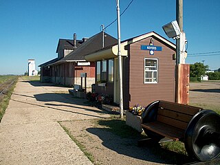
Rivers is an unincorporated urban community in the Riverdale Municipality within the Canadian province of Manitoba. It is located 40 kilometres (25 mi) northwest of Brandon, 473 metres (1,552 ft) above sea level. It is within the Westman Region. Agriculture, health and related businesses provide income for the community and area. Rivers has a population of 1,257 people in the 2016 census.
Binscarth is an unincorporated urban community in the Municipality of Russell – Binscarth, Manitoba. It is located approximately 167 km (104 mi) northwest of Brandon, 16 km (9.9 mi) south from Russell, and 16 km (10 mi) east of the Saskatchewan border.
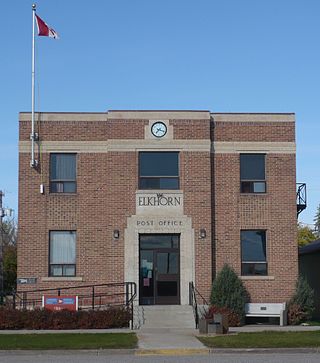
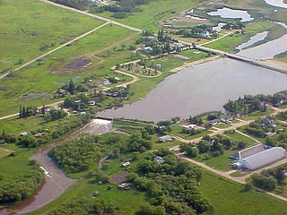
Elkhorn is an unincorporated community recognized as a local urban district in the Rural Municipality of Wallace – Woodworth within the Canadian province of Manitoba that held village status prior to January 1, 2015. It was originally incorporated as a village on January 2, 1906. Elkhorn is located approximately 105 kilometres (65 mi) west of Brandon.

Arcola is a town in south-east Saskatchewan, Canada, approximately 60 kilometres (37 mi) north and 40 kilometres (25 mi) east of Estevan. Highway 13, Highway 604, and Arcola Airport provide access to the community.
MacGregor is a community in the Canadian province of Manitoba. It held town status prior to January 1, 2015 when it amalgamated with the Rural Municipality of North Norfolk to form the Municipality of North Norfolk. MacGregor is located approximately 130 km (81 mi) west of Winnipeg and 80 km (50 mi) east of Brandon. It is a farming community, with the biggest industry in the area being agriculture. The community is surrounded by farms, and the Trans-Canada Highway is located just north of MacGregor.
Rapid City is an unincorporated community recognized as a local urban district that also once held town status in southwest Manitoba, Canada within the Rural Municipality of Oakview. It is located about 30 km north of Brandon. Rapid City is a farming community that is developed on the banks of the Little Saskatchewan River. The dam and reservoir in Rapid City were built by the province in 1961, the reservoir stores 200 acre-feet (250,000 m3) and provides a water supply and recreational facility for the community.

Wawanesa is an unincorporated urban community in the Municipality of Oakland – Wawanesa within the Canadian province of Manitoba that held village status before January 1, 2015. It is the birthplace of The Wawanesa Mutual Insurance Co.

Waskada is an unincorporated urban community in the Municipality of Brenda – Waskada within the Canadian province of Manitoba that held village status prior to January 1, 2015. It is located in the southwest corner of the province, close to the United States and Saskatchewan borders. It was settled as early as 1883 and incorporated as a village in 1948. Waskada has a population of 183, and covers a land area of 0.77 km2. Though traditionally a farming community, a recent oil boom has also brought economic activity to the area.

Gainsborough is a village in the Canadian province of Saskatchewan within the Rural Municipality of Argyle No. 1 and Census Division No. 1. A farming community, the village is located on Highway 18 in the southeastern corner of Saskatchewan. Gainsborough is approximately 6 km (3.7 mi) from the Manitoba border, and 19 km (12 mi) from the North Dakota, United States border. The first post office was established on April 1, 1884 as the community of Antler. On September 1, 1885 the name of the community changed to Gainsborough, after Gainsborough, Lincolnshire in England, which was the former home of J. J. Sadler, an early settler.

The Rural Municipality of Sifton is a rural municipality (RM) in the south-west portion of the Canadian province of Manitoba.

Division No. 5 is a census division located within the Westman Region in the south west area of the province of Manitoba, Canada. Unlike in some other provinces, census divisions do not reflect the organization of local government in Manitoba. These areas exist solely for the purposes of statistical analysis and presentation; they have no government of their own.
Division No. 7 is a census division located within the Westman Region in the south western area of the province of Manitoba, Canada. Unlike in some other provinces, census divisions do not reflect the organization of local government in Manitoba. These areas exist solely for the purposes of statistical analysis and presentation; they have no government of their own.
The Municipality of Grassland is a rural municipality (RM) in the Canadian province of Manitoba.

The Municipality of Souris – Glenwood is a rural municipality (RM) in the Canadian province of Manitoba.