Ninette, Manitoba

Last updated

Ninette
Coming into Ninette Manitoba Canada.jpg
Entering Ninette
CountryCanada
ProvinceManitoba
Area
  Total1.92 km2 (0.74 sq mi)
Population
 (2016)
  Total224 [1]
  Density115.4/km2 (299/sq mi)

Ninette is an unincorporated community recognized as a local urban district [2] located in Manitoba, Canada at the north end of Pelican Lake. It is located in the Rural Municipality of Prairie Lakes. Ninette has many small businesses, and is known locally for its wide range of sports facilities. In the summer, activities such as boating, fishing, and hunting are offered, while snowmobiling and ice fishing are offered during the wintertime. [3]

Contents

History

Ninette's original post office was established in 1883 on a site near Overend Lake. It was later moved, following the construction of the Northern Pacific and Manitoba Railway in the area, to its current site near Pelican Lake, closer to the railway. In June 1926, Ninette became an unincorporated village. [3]

There are multiple theories as to the name of the community, including being named informally for a French actress or waitress, the deceased daughter of a local resident, or a character in a novel that was being read by a postal inspector in the area, the name being short for Antoinette. [3] [4]

The Manitoba Sanatorium, a sanatorium for tuberculosis patients in the province, opened in May 1910 nearby on Pelican Lake's north shore, causing a growth in Ninette's population from the sanatorium's staff and patients' families, [3] especially as its capacity quadrupled in its first 13 years. The sanatorium closed in 1972 after the development and prevalence of tuberculosis drugs and other treatments made the facility obsolete. [5]

Demographics

In the 2021 Census of Population conducted by Statistics Canada, Ninette had a population of 249 living in 120 of its 142 total private dwellings, a change of

In the 2016 Canadian census, the median age was 53.7 years old, 12.7 years older than the national average of 41.0. There were 110 private dwellings, 105 of which were occupied.

English-speakers comprise the vast majority of Ninette's population. In terms of Canada's official languages, 95.3% of the population speaks exclusively English, while the remaining 4.7% speaks both English and French. No other languages are spoken or known in the community.

Of those in Ninette aged 15 or older, 48.7% are married, 15.4% are living with a common-law partner, 23% have never been married, 2.6% are separated, 5.1% are divorced, and 7.7% are widowed.

Of the census families in Ninette, 71.4% consist of two persons, 21.4% consist of three persons, and the remaining 7.1% consist of five or more persons. The average size of a census family is 2.4 persons. Out of all of Ninette's couple census families, 66.7% are without children, while 25% have one child, and 8.3% have three or more children. [1]

Transportation

Ninette is located along the intersection of Manitoba Highways 18 and 23, which connects it to several other communities in the region, as well as the North Dakota border and the Pembina Valley region of the province.

Climate

Ninette has a humid continental climate (Köppen climate classification Dfb ) It falls into the NRC Plant Hardiness Zone 4a. [7]

Information listed below is from Environment Canada Belmont Weather station

Climate data for Belmont , elevation: 481.6 m (1,580 ft), 1981–2010 normals
MonthJanFebMarAprMayJunJulAugSepOctNovDecYear
Average precipitation mm (inches)23.6
(0.93)
26.2
(1.03)
27.0
(1.06)
26.3
(1.04)
76.4
(3.01)
96.6
(3.80)
78.3
(3.08)
69.2
(2.72)
39.7
(1.56)
37.3
(1.47)
27.2
(1.07)
30.8
(1.21)
558.6
(21.99)
Average rainfall mm (inches)0.0
(0.0)
1.2
(0.05)
7.1
(0.28)
15.1
(0.59)
72.5
(2.85)
96.6
(3.80)
78.3
(3.08)
69.2
(2.72)
39.3
(1.55)
29.6
(1.17)
4.0
(0.16)
0.2
(0.01)
413.0
(16.26)
Average snowfall cm (inches)23.6
(9.3)
25.0
(9.8)
19.9
(7.8)
11.2
(4.4)
3.9
(1.5)
0.0
(0.0)
0.0
(0.0)
0.0
(0.0)
0.4
(0.2)
7.7
(3.0)
23.3
(9.2)
30.6
(12.0)
145.5
(57.3)
Source: Environment Canada [8] [9]

Notable people

Books

Songs

See also

Related Research Articles

<span class="mw-page-title-main">Morden, Manitoba</span> City in Manitoba, Canada

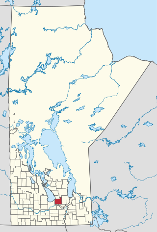
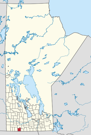
Morden is a city located in the Pembina Valley region of southern Manitoba, Canada near the United States border. It is about 11 km (6.8 mi) west of the neighbouring city of Winkler; together Morden and Winkler are often referred to as Manitoba's Twin Cities. Morden, which is surrounded by the Rural Municipality of Stanley, is the eighth largest and fastest-growing city in Manitoba. According to Statistics Canada, the city had a population of 9,929 in 2021, an increase of 14.5% from 2016, making it Manitoba's fastest growing city.

Lundar is a local urban district in the Rural Municipality of Coldwell, Manitoba, Canada. Located in Manitoba's Interlake Region, it is situated 99 km (62 mi) north of Winnipeg on Highway 6.

The Rural Municipality of Lakeview was a rural municipality (RM) in the Canadian province of Manitoba.

<span class="mw-page-title-main">Gladstone, Manitoba</span> Unincorporated community in Manitoba, Canada

Gladstone is an unincorporated urban community in the Municipality of WestLake – Gladstone within the Canadian province of Manitoba that held town status prior to January 1, 2015. It is located on the Yellowhead Highway at the intersection with Highway 34. The Gladstone railway station receives Via Rail service.

Powerview-Pine Falls is a town in the Canadian province of Manitoba, with a population of 1,314 at the 2011 census, up 1.54% from 1,294 at the 2006 census and down 7.57% from 1,400 during the 2001 census.

<span class="mw-page-title-main">Northern Woods and Water Route</span> Highway in Canada

The Northern Woods and Water Route is a 2,400-kilometre (1,500 mi) route through northern British Columbia, Alberta, Saskatchewan and Manitoba in Western Canada. As early as the 1950s, community groups came together to establish a northern travel route; this was proposed as the Northern Yellowhead Transportation Route. The Northern Woods and Water Route Association was established in 1974, and encouraged promotion of the route with the promise of an increase in tourist travel. The route was designated in 1974 and is well signed throughout its component highways. The route starts at Dawson Creek as the Spirit River Highway and ends at the Perimeter of Winnipeg, Manitoba, after running through the northern regions of the western provinces. From west to east, the Northern Woods and Water Route (NWWR) incorporates portions of British Columbia Highway 49; Alberta Highways 49, 2A, 2, & 55; Saskatchewan Highways 55 & 9; Manitoba Provincial Road 283 and Trunk Highways 10, 5, 68 & 6. The halfway point of the NWWR is approximately at Goodsoil, Saskatchewan.

<span class="mw-page-title-main">Rural Municipality of Excelsior No. 166</span> Rural municipality in Saskatchewan, Canada

The Rural Municipality of Excelsior No. 166 is a rural municipality (RM) in the Canadian province of Saskatchewan within Census Division No. 7 and SARM Division No. 3.

<span class="mw-page-title-main">Rural Municipality of Spiritwood No. 496</span> Rural municipality in Saskatchewan, Canada

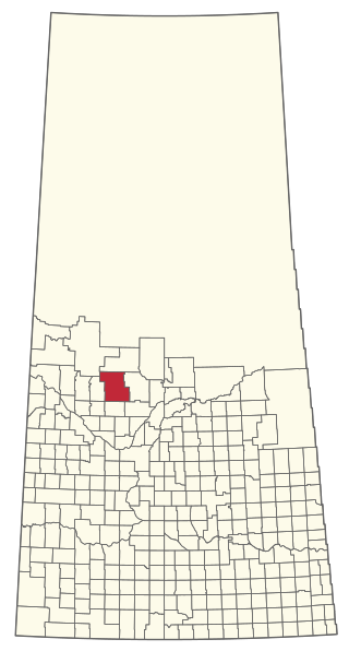
The Rural Municipality of Spiritwood No. 496 is a rural municipality (RM) in the Canadian province of Saskatchewan within Census Division No. 16 and SARM Division No. 6. Located in the north-central portion of the province, it is west of the City of Prince Albert.

<span class="mw-page-title-main">Rural Municipality of Reno No. 51</span> Rural municipality in Saskatchewan, Canada

The Rural Municipality of Reno No. 51 is a rural municipality (RM) in the Canadian province of Saskatchewan within Census Division No. 4 and SARM Division No. 3. Located in the southwest corner of the province, it is adjacent to the United States border to the south and the Alberta boundary to the west.

The Rural Municipality of Riverside is a former rural municipality (RM) in the Canadian province of Manitoba. It was originally incorporated as a rural municipality on December 22, 1883. It ceased on January 1, 2015 as a result of its provincially mandated amalgamation with the RM of Strathcona to form the Rural Municipality of Prairie Lakes. In 2011 the RM had a population of 780 which had declined from a population of 809 in 2006.

<span class="mw-page-title-main">Rural Municipality of Woodlands</span> Rural municipality in Manitoba, Canada

Woodlands is a rural municipality (RM) in the province of Manitoba in Western Canada. It lies in the southern part of the Interlake and is named for the community of Woodlands, which itself is named for the wooded lands of the area.

<span class="mw-page-title-main">Rural Municipality of Stuartburn</span> Rural municipality in Manitoba, Canada

Stuartburn is a rural municipality (RM) located in the Eastman Region of Manitoba, Canada. It had a population of 1,629 according to the Canada 2006 Census.

<span class="mw-page-title-main">Municipality of Killarney-Turtle Mountain</span> Rural municipality in Manitoba, Canada

Killarney-Turtle Mountain is a rural municipality (RM) located in the Westman Region of Manitoba, Canada. It is located to the immediate north of the Canada–United States border opposite Rollete and Towner Counties, North Dakota.

<span class="mw-page-title-main">Rural Municipality of La Broquerie</span> Rural municipality in Manitoba, Canada

La Broquerie is a rural municipality in the province of southern Manitoba, located just southeast of the city of Steinbach.

<span class="mw-page-title-main">Rural Municipality of Harris No. 316</span> Rural municipality in Saskatchewan, Canada

The Rural Municipality of Harris No. 316 is a rural municipality (RM) in the Canadian province of Saskatchewan within Census Division No. 12 and SARM Division No. 5.

<span class="mw-page-title-main">Rural Municipality of Meota No. 468</span> Rural municipality in Saskatchewan, Canada

The Rural Municipality of Meota No. 468 is a rural municipality (RM) in the Canadian province of Saskatchewan within Census Division No. 17 and SARM Division No. 6.

<span class="mw-page-title-main">Municipality of Bifrost-Riverton</span> Rural municipality in Manitoba, Canada

The Municipality of Bifrost-Riverton is a rural municipality (RM) in the Canadian province of Manitoba, and is one of the northernmost rural municipalities in the Interlake Region.

<span class="mw-page-title-main">Rural Municipality of Lakeshore</span> Rural municipality in Manitoba, Canada

The Rural Municipality of Lakeshore is a rural municipality (RM) in the Parkland Region of Manitoba, Canada.

<span class="mw-page-title-main">Rural Municipality of Prairie Lakes</span> Rural municipality in Manitoba, Canada

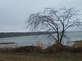
The Rural Municipality of Prairie Lakes is a rural municipality (RM) in the Canadian province of Manitoba. The Rural Municipality of Prairies lakes surrounds most of the north end of Pelican Lake. There are several other lakes in the RM such as Grass Lake, Overend Lake, Bone Lake, Lorne Lake, Louise Lake, Lloyds Lake, Noble Lake and many more that are all much smaller than Pelican Lake.

References

  1. 1 2 "Census Profile: Ninette (Local urban district)". Statistics Canada. Retrieved August 10, 2017.
  2. "Local Urban Districts Regulation". Government of Manitoba. April 23, 2016. Retrieved April 24, 2016.
  3. 1 2 3 4 "Pelican Lake" . Retrieved August 17, 2015.
  4. "Manitoba Communities: Ninette (Unincorporated Village, RM of Prairie Lakes)". Manitoba Historical Society. Retrieved August 7, 2017.
  5. "Manitoba History: Famous Places: The Manitoba Sanatorium, Ninette". Manitoba Historical Society. Retrieved August 7, 2017.
  6. "Population and dwelling counts: Canada and designated places". Statistics Canada. February 9, 2022. Retrieved September 3, 2022.
  7. "Plant Hardiness Zone by Municipality". Natural Resources Canada. Government of Canada. Retrieved March 26, 2016.
  8. "Belmont". Canadian Climate Normals 1981–2010. Environment Canada. Archived from the original on July 17, 2020. Retrieved October 26, 2013.
  9. "Canadian Climate Normals 1981-2010 Station Data - Belmont, MB". Government of Canada. Retrieved November 25, 2021.

49°24′00″N99°37′43″W / 49.40000°N 99.62861°W / 49.40000; -99.62861