
Lake Agassiz was a large proglacial lake that existed in central North America during the late Pleistocene, fed by meltwater from the retreating Laurentide Ice Sheet at the end of the last glacial period. At its peak, the lake's area was larger than all of the modern Great Lakes combined. It eventually drained into what is now Hudson Bay, leaving behind Lake Winnipeg, Lake Winnipegosis, Lake Manitoba, and Lake of the Woods.

Lake Manitoba is the 14th largest lake in Canada and the 33rd largest lake in the world with a total area of 4,624 square kilometres (1,785 sq mi). It is located within the Canadian province of Manitoba about 75 kilometres (47 mi) northwest of the province's capital, Winnipeg, at 50°59′N98°48′W.

The Red River Floodway is an artificial flood control waterway in Western Canada. It is a 47 km (29 mi) long channel which, during flood periods, takes part of the Red River's flow around the city of Winnipeg, Manitoba to the east and discharges it back into the Red River below the dam at Lockport. It can carry floodwater at a rate of up to 140,000 cubic feet per second (4,000 m3/s), expanded in the 2000s from its original channel capacity of 90,000 cubic feet per second (2,500 m3/s).

The Assiniboine River is a 1,070-kilometre (660 mi) long river that runs through the prairies of Western Canada in Saskatchewan and Manitoba. It is a tributary of the Red River. The Assiniboine is a typical meandering river with a single main channel embanked within a flat, shallow valley in some places and a steep valley in others. Its main tributaries are the Qu'Appelle, Souris, and Whitesand Rivers.
In hydrology, discharge is the volumetric flow rate of a stream. It equals the product of average flow velocity and the cross-sectional area. It includes any suspended solids, dissolved chemicals like CaCO
3(aq), or biologic material in addition to the water itself. Terms may vary between disciplines. For example, a fluvial hydrologist studying natural river systems may define discharge as streamflow, whereas an engineer operating a reservoir system may equate it with outflow, contrasted with inflow.

The Ogoki River is a river in the Thunder Bay and Cochrane Districts of Ontario. It springs from the wilderness just east of Savant Lake, flowing north of Lake Nipigon to Ogoki, where it joins the Albany River which empties into James Bay. The river is 480 kilometres (300 mi) long.
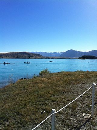
Lake Ruataniwha is an artificial lake in the Mackenzie Basin in the South Island of New Zealand. It was formed in 1977–1981 as part of the Waitaki hydroelectric project. It lies on the traditional boundary of the Canterbury and Otago provinces, with the town of Twizel two kilometres to the north.
The Albany River is a river in Northern Ontario, Canada, which flows northeast from Lake St. Joseph in Northwestern Ontario and empties into James Bay. It is 982 kilometres (610 mi) long to the head of the Cat River, tying it with the Severn River for the title of longest river entirely in Ontario. Major tributaries include the Kenogami River and Ogoki River.
The Shellmouth Reservoir is a man-made reservoir on the Assiniboine River in Manitoba and Saskatchewan, Canada.

The Portage Diversion is a water control structure on the Assiniboine River near Portage la Prairie, Manitoba, Canada. The project was made as part of a larger attempt to prevent flooding in the Red River Valley. The Portage Diversion consists of two separate gates which divert some of the flow of water in the Assiniboine River to a 29 km long diversion channel that empties into Lake Manitoba near Delta Beach. This helps prevent flooding on the Assiniboine down river from the diversion, including in Winnipeg, where the Assiniboine River meets the Red River.

The Nelson River Hydroelectric Project refers to the construction of a series of dams and hydroelectric power plants on the Nelson River in Northern Manitoba, Canada. The project began to take shape in the late 1950s, with the planning and construction of the Kelsey dam and hydroelectric power station, and later was expanded to include the diversion of the upper Churchill River into the Nelson River and the transformation of Lake Winnipeg, the world's 11th largest freshwater lake, into a hydroelectric reservoir. The project is owned and operated by Manitoba Hydro, the electrical utility in the province.

The Mori–Torbole Tunnel is a diversion tunnel completed in 1959 between the Italian towns of Mori and Nago-Torbole to connect the Adige river with Lake Garda.

Glen Canyon Dam, a concrete arch dam on the Colorado River in the American state of Arizona, is viewed as carrying a large amount of risk, most notably due to siltation. The Colorado and San Juan rivers deposit large volumes of silt into Lake Powell, slowly decreasing its capacity. The sediment will eventually build up against the dam and could affect its safe operation and lead to its failure.

Twin Lakes Beach, also known locally by many as simply Twin Beaches, is a beach and community in the Canadian province of Manitoba. On Lake Manitoba, it is about 100 kilometres (62 mi) north-west of the provincial capital, Winnipeg. Twin Lakes Beach is in both the Rural Municipality of St. Laurent and the Rural Municipality of Woodlands, and it is in the town of St. Laurent.
The 2011 Assiniboine River flood was caused by above average precipitation in Western Manitoba and Saskatchewan. This was a 1 in 300 year flood that affected much of Western Manitoba. The flooding in Manitoba was expected to mostly involve the 2011 Red River Flood but instead the more severe flooding was found on the Assiniboine in the west.

The Pandoh Dam is an embankment dam on the Beas River in Mandi district of Himachal Pradesh, India. Under the Beas Project, the dam was completed in 1977 and its primary purpose is hydroelectric power generation. Part of a run-of-the-river power scheme, it diverts the waters of the Beas to the southwest through a 38 km (24 mi) long system of tunnels and channels. The water is used for power generation at the Dehar Power House before being discharged into the Sutlej River, connecting both rivers. The power house has an installed capacity of 990 MW. The system diverts 256 cumecs of Beas waters to the Satluj River. The project was completed in 1977.
The Greater Winnipeg Water District Aqueduct (GWWDA) is an aqueduct that supplies the city of Winnipeg, Manitoba, with water from Shoal Lake, Kenora District, Ontario. Winnipeg has relied on the lake as its source for safe drinking water since the aqueduct was put in service in 1919 at a cost of nearly CDN $16 million.

Lake St. Martin is a lake in the Interlake region of Manitoba, Canada. The lake is situated between Lake Manitoba and Lake Winnipeg. Lake St. Martin is downstream from the Fairford River with its Fairford River Control Structure. The Fairford River is the only outlet for Lake Manitoba. With the artificially increased flow and limited outflow, Lake St. Martin was turned into a reservoir. The outflow for Lake St. Martin exits through Dauphin River and into Lake Winnipeg, at a lower rate than the water comes in.
Rock Lake is the second largest navigable lake in southwestern Manitoba, Canada. It is about 8 miles (13 km) long and 0.75 miles (1.21 km) wide with a surface area of 6.6 square miles (17 km2). Rock Lake is relatively shallow with a mean depth of 2.5 metres and a maximum of 3.5 metres (11 ft) when the lake is at a surface water level of 405.08 metres (1,329.0 ft). The summer target for the lake is 405.08 metres (1,329.0 ft). The lake is fed by several waterways the main ones being the Pembina River and Badger Creek. The total drainage area is 3,842 square kilometres (1,483 sq mi).
The Hodge decision is a flow requirement that several water agencies must follow when they extract surface water from the American River. The flow requirements vary throughout the year, with the spring and summer months of March through June presenting the most restricted rate, at a minimum of 3,000 cubic feet per second (85 m3/s). The agencies must maintain these specified flow rates to divert water from the American River. If the American River's flow rate is less than the specified minimum rate, some water agencies must obtain water from other sources.


