Lena, Manitoba

Last updated

Lena
Grain Elevator at Lena, Manitoba.JPG
Grain Elevator at Lena
Canada Manitoba location map 2.svg
Red pog.svg
Lena
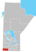
Location of Lena in Manitoba
Coordinates: 49°4′16″N99°39′42″W / 49.07111°N 99.66167°W / 49.07111; -99.66167
Country Flag of Canada (Pantone).svg  Canada
Province Flag of Manitoba.svg  Manitoba
Region Westman
Census Division No. 5
Government
  Governing BodyMunicipality of Killarney-Turtle Mountain Council
   MP Larry Maguire
   MLA Grant Jackson
Time zone UTC−6 (CST)
  Summer (DST) UTC−5 (CDT)
Area code(s) 204, 431
NTS Map062G04
GNBC CodeGAOLN

Lena is an unincorporated community located in the Municipality of Killarney-Turtle Mountain in south central Manitoba, Canada. It is located approximately 89 kilometers (55 miles) southeast of Brandon, Manitoba, [1] at the junction of Manitoba Highway 18 and Provincial Road 341.

Related Research Articles

<span class="mw-page-title-main">Manitoba</span> Canadian province

Manitoba is a province of Canada at the longitudinal centre of the country. It is Canada's fifth-most populous province, with a population of 1,342,153 as of 2021. Manitoba has a widely varied landscape, from arctic tundra and the Hudson Bay coastline in the north to dense boreal forest, large freshwater lakes, and prairie grassland in the central and southern regions.

<span class="mw-page-title-main">Winnipeg</span> Capital city of Manitoba, Canada

Winnipeg is the capital and largest city of the province of Manitoba in Canada. It is centred on the confluence of the Red and Assiniboine rivers, near the longitudinal centre of North America. As of 2021, Winnipeg had a city population of 749,607 and a metropolitan population of 834,678, making it Canada's sixth-largest city and eighth-largest metropolitan area.

<span class="mw-page-title-main">Brandon, Manitoba</span> City in Manitoba, Canada

Brandon is the second-largest city in the province of Manitoba, Canada. It is located in the southwestern corner of the province on the banks of the Assiniboine River, approximately 214 km (133 mi) west of the provincial capital, Winnipeg, and 120 km (75 mi) east of the Saskatchewan border. Brandon covers an area of 77.41 km2 (29.89 sq mi) with a population of 51,313, and a census metropolitan area population of 54,268. It is the primary hub of trade and commerce for the Westman Region as well as parts of southeastern Saskatchewan and northern North Dakota, an area with a population of over 190,000 people.

<span class="mw-page-title-main">Flin Flon</span> City in Manitoba and Saskatchewan, Canada

Flin Flon is a mining city, located on a correction line on the border of the Canadian provinces of Manitoba and Saskatchewan, with the majority of the city located within Manitoba. Residents thus travel southwest into Saskatchewan, and northeast into Manitoba. The city is incorporated in and is jointly administered by both provinces.

<span class="mw-page-title-main">Portage la Prairie</span> City in Manitoba, Canada

Portage la Prairie is a small city in the Central Plains Region of Manitoba, Canada. As of 2016, the population was 13,304 and the land area of the city was 24.68 square kilometres (9.53 sq mi).

Roblin is an unincorporated urban community in the Municipality of Roblin, Manitoba, Canada. It is located approximately 400 km (250 mi) northwest of Winnipeg.

<span class="mw-page-title-main">Morden, Manitoba</span> City in Manitoba, Canada

Morden is a city located in the Pembina Valley region of southern Manitoba, Canada near the United States border. It is about 11 km (6.8 mi) west of the neighbouring city of Winkler; together Morden and Winkler are often referred to as Manitoba's Twin Cities. Morden, which is surrounded by the Rural Municipality of Stanley, is the eighth largest and fastest-growing city in Manitoba. According to Statistics Canada, the city had a population of 9,929 in 2021, an increase of 14.5% from 2016, making it Manitoba's fastest growing city.

Lena or LENA may refer to:

<span class="mw-page-title-main">Minnedosa, Manitoba</span> Town in Manitoba, Canada

Minnedosa is a town in the southwestern part of the Canadian province of Manitoba situated 50 kilometres (32 mi) north of Brandon, Manitoba on the Little Saskatchewan River. The town's name means "flowing water" in the Dakota language. The population of Minnedosa reported in the 2021 Canadian Census was 2,741. The town is surrounded by the Rural Municipality of Minto – Odanah.

<span class="mw-page-title-main">David Bergen</span> Canadian writer

David Bergen is a Canadian novelist. He has published eleven novels and two collections of short stories since 1993 and is currently based in Winnipeg, Manitoba, Canada. His 2005 novel The Time in Between won the Scotiabank Giller Prize and he was a finalist again in 2010 and 2020, making the long list in 2008.

<span class="mw-page-title-main">Waskada</span> Former village in Manitoba, Canada

Waskada is an unincorporated urban community in the Municipality of Brenda – Waskada within the Canadian province of Manitoba that held village status prior to January 1, 2015. It is located in the southwest corner of the province, close to the United States and Saskatchewan borders. It was settled as early as 1883 and incorporated as a village in 1948. Waskada has a population of 183, and covers a land area of 0.77 km2. Though traditionally a farming community, a recent oil boom has also brought economic activity to the area.

The Rural Municipality of Miniota is a former rural municipality (RM) in the Canadian province of Manitoba. It was originally incorporated as a rural municipality on December 22, 1883. It ceased on January 1, 2015 as a result of its provincially mandated amalgamation with the RM of Birtle and the Town of Birtle to form the Prairie View Municipality.

Provincial Trunk Highway 18 is a provincial highway in the Canadian province of Manitoba. Located in the Westman Region, it is a north-south route, with the southern terminus at the St. John–Lena Border Crossing at the Canada–United States border and the northern terminus at PTH 2, 7.1 kilometres southeast of Wawanesa. The highway passes through the communities of Killarney and Ninette. It is designated as an RTAC route, meaning it is capable of handling RTAC vehicles such as a truck, a truck and pony trailer, a truck and full trailer, a truck tractor and semi-trailer, an A-train, a B-train, or a C-train.

<span class="mw-page-title-main">Municipality of Killarney-Turtle Mountain</span> Rural municipality in Manitoba, Canada

Killarney-Turtle Mountain is a rural municipality (RM) located in the Westman Region of Manitoba, Canada. It is located to the immediate north of the Canada–United States border opposite Rollete and Towner Counties, North Dakota.

<span class="mw-page-title-main">St. John–Lena Border Crossing</span> Border crossing between Canada and the United States

The St. John–Lena Border Crossing connects the towns of St. John, North Dakota and Killarney, Manitoba on the Canada–United States border. North Dakota Highway 30 on the American side joins Manitoba Highway 18 on the Canadian side.

References

  1. "Geographical Names of Canada - Querying Distances". nrcan.gc.ca. Archived from the original on December 11, 2013. Retrieved December 8, 2013.

See also