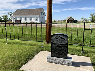
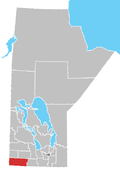
Neelin is a small community in the Canadian province of Manitoba. It is located on Manitoba Provincial Highway 5 in the Rural Municipality of Argyle, about 29 km east of Killarney, or about 200 km southwest of Winnipeg.

A grain elevator is a facility designed to stockpile or store grain. In the grain trade, the term "grain elevator" also describes a tower containing a bucket elevator or a pneumatic conveyor, which scoops up grain from a lower level and deposits it in a silo or other storage facility.
Coleville is a village in the Canadian province of Saskatchewan within the Rural Municipality of Oakdale No. 320 and Census Division No. 13. The village's main economic factors are oil and farming, namesake of the Coleville oilfields. The village is named for Malcolm Cole who became the community's first postmaster in 1908.

Lafleche is a small town in southwest Saskatchewan, Canada in the Rural Municipality of Wood River No. 74. The community is located at the intersection of Highway 13 and Highway 58. It is 20 km south of Gravelbourg and 45 km west of Assiniboia. It is situated on the south bank of Lafleche Creek, which is a tributary of Wood River. Thomson Lake Regional Park is located 10 minutes north of town.
McCreary is an unincorporated urban community in the Municipality of McCreary, Manitoba, Canada.

Headingley is a rural municipality in Manitoba, Canada. It is located directly west of Winnipeg and had a population of 3,579 people as of the 2016 census.

Pilot Mound is an unincorporated community recognized as a local urban district that also once held town status in the Canadian province of Manitoba. It is located within the Municipality of Louise, approximately 60 km west of the City of Morden.
St. Vital is a ward and neighbourhood of Winnipeg, Manitoba, Canada.
Binscarth is an unincorporated urban community in the Municipality of Russell – Binscarth, Manitoba. It is located approximately 167 km (104 mi) northwest of Brandon, 16 km (9.9 mi) south from Russell, and 16 km (10 mi) east of the Saskatchewan border.
Rockglen is a town in the Burning Hills of the Wood Mountain Uplands, in Saskatchewan, Canada. It offers various amenities including a school, community hall, public library and five parks, as well a local service industry. The municipal office of the Rural Municipality of Poplar Valley No. 12 lies within the boundaries of Rockglen, and Rockglen businesses are supported primarily by agriculture. In the Burning Hills agriculture consists of dry land farming and cattle. Rockglen is located along Highway 2 south of Assiniboia, Highway 18 west of Coronach, and Highways 2 and 18 north of Port Poplar River. Fife Lake is 9.3 kilometres (5.8 mi) to the east.
Arbuthnot is an unincorporated community located in Glen Bain Rural Municipality No. 105, Saskatchewan, Canada east of Route 19. It was located in census Division No. 2. It was on mile 63 of the Canadian Pacific Railway right of way, southeast of Swift Current and in the NW section 9- township 10- range 7 west of the third meridian.

Warren is an unincorporated community recognized as a local urban district 26.3 kilometres north-west of Winnipeg, Manitoba. It is located in the Rural Municipality of Woodlands.

Robsart is an unincorporated hamlet within the rural municipality of Reno No. 51, in the province of Saskatchewan, Canada. Robsart had a population of 20 at the 2016 Canada Census. Robsart previously incorporated an independent village since 1912 until it was dissolved into an unincorporated community on January 1, 2002 under the jurisdiction of the rural municipality of Reno No. 51. Robsart is located 48 km southwest of the town of Eastend at the junction of Highway 18 and Highway 13 approximately 170 km south-east of Medicine Hat, Alberta, 68 km south of the Town of Maple Creek.
Govenlock is an unincorporated community within the Rural Municipality of Reno No. 51, Saskatchewan, Canada. It previously held the status of a village, with a peak population of 151 residents; its village status was dissolved on January 1, 1976. The former townsite of Govenlock is located on Highway 21 & Highway 13, also known as the historic Red Coat Trail, about 15 km east of the Alberta-Saskatchewan border. Although many cement foundations and wooden sidewalks can still be found scattered around the town site, the only building that still stands as of 2010 is the old community hall and a commemorative plaque in remembrance of Govenlock's rich history.
The Warner elevator row is a group of four historic wood-cribbed grain elevators standing in a row from south to north alongside the Canadian Pacific Railway line from Great Falls, Montana to Lethbridge, Alberta at the east entrance of the village of Warner, Alberta, Canada. At one time, the row had at least seven elevators.
Travers is a hamlet in southern Alberta, Canada within Vulcan County. It is located approximately 59 kilometres (37 mi) southwest of Highway 1 and 59 kilometres (37 mi) southwest of Brooks.
Alexander, Manitoba, is a local urban district in the Rural Municipality of Whitehead, situated on Highway 1, west of Brandon.

Horizon, located on the south side of Channel Lake, is a hamlet in Bengough Rural Municipality No. 40, Saskatchewan, Canada. It previously held the status of village until December 31, 1973. The hamlet is located 60 km (37 mi) east of the Town of Assiniboia on highway 13.

Randolph, originally known as Chortitz, is a small community in the Rural Municipality of Hanover, Manitoba, Canada. The community has an estimated population of 70 and is located 1.6 kilometres north of Highway 52 on Provincial Road 206 about 11 kilometres west of Steinbach. Randolph is located within a half kilometre of the longitudinal centre of Canada.
Gordon is an unincorporated community in Manitoba, Canada, within the Rural Municipality of Rosser. The community is centred on PTH 6, approximately 3.5 kilometres north-west of Winnipeg and 9.5 kilometres south-east of Grosse Isle. It is named for James Gordon, who was in charge of leases in the General Manager's Office of the Canadian National Railway.


