Elva, Manitoba

Last updated

Elva
Canada Manitoba location map 2.svg
Red pog.svg
Elva
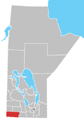
Location of Elva in Manitoba
Coordinates: 49°12′58″N101°6′55″W / 49.21611°N 101.11528°W / 49.21611; -101.11528
Country Flag of Canada (Pantone).svg  Canada
Province Flag of Manitoba.svg  Manitoba
Region Westman
Census Division No. 5
Government
   MP Larry Maguire
   MLA Doyle Piwniuk
Time zone UTC−6 (CST)
  Summer (DST) UTC−5 (CDT)
Area code(s) 204, 431
NTS Map062F03
GNBC CodeGAHSS

Elva is an unincorporated community located within the Municipality of Two Borders in south-western Manitoba, Canada. It is located approximately 10 kilometers (6 miles) southwest of Melita, Manitoba. [1] Manitoba Provincial Road 252 (PR 252) passes through the community, as does a railroad line.

Related Research Articles

<span class="mw-page-title-main">Brandon, Manitoba</span> City in Manitoba, Canada

Brandon is the second-largest city in the province of Manitoba, Canada. It is located in the southwestern corner of the province on the banks of the Assiniboine River, approximately 214 km (133 mi) west of the provincial capital, Winnipeg, and 120 km (75 mi) east of the Saskatchewan border. Brandon covers an area of 77.41 km2 (29.89 sq mi) with a population of 51,313, and a census metropolitan area population of 54,268. It is the primary hub of trade and commerce for the Westman Region as well as parts of southeastern Saskatchewan and northern North Dakota, an area with a population of over 190,000 people.

<span class="mw-page-title-main">Flin Flon</span> City in Manitoba and Saskatchewan, Canada

Flin Flon is a mining city, located on a correction line on the border of the Canadian provinces of Manitoba and Saskatchewan, with the majority of the city located within Manitoba. Residents thus travel southwest into Saskatchewan, and northeast into Manitoba. The city is incorporated in and is jointly administered by both provinces.

<span class="mw-page-title-main">Portage la Prairie</span> City in Manitoba, Canada

Portage la Prairie is a small city in the Central Plains Region of Manitoba, Canada. As of 2016, the population was 13,304 and the land area of the city was 24.68 square kilometres (9.53 sq mi).

Roblin is an unincorporated urban community in the Municipality of Roblin, Manitoba, Canada. It is located approximately 400 km (250 mi) northwest of Winnipeg.

<span class="mw-page-title-main">Manitou, Manitoba</span> Place in Manitoba, Canada

Manitou is an unincorporated urban community in the Municipality of Pembina within the Canadian province of Manitoba that held town status prior to January 1, 2015. The Boundary Trail Railway is based in Manitou. The community's motto is "More Than A Small Town". The community is adjacent to PTH 3 and PR 244. Manitou is located near Mennonite communities such as Winkler, Manitoba and is right next to the St. Leon Wind Farm, the largest wind farm in Manitoba and one of the largest in Canada.

<span class="mw-page-title-main">Thompson, Manitoba</span> City in Manitoba, Canada

Thompson is a city in north-central Manitoba, Canada, the largest city and most populated municipality in Northern Manitoba.

<span class="mw-page-title-main">Morden, Manitoba</span> City in Manitoba, Canada

Morden is a city located in the Pembina Valley region of southern Manitoba, Canada near the United States border. It is about 11 km (6.8 mi) west of the neighbouring city of Winkler; together Morden and Winkler are often referred to as Manitoba's Twin Cities. Morden, which is surrounded by the Rural Municipality of Stanley, is the eighth largest and fastest-growing city in Manitoba. According to Statistics Canada, the city had a population of 9,929 in 2021, an increase of 14.5% from 2016, making it Manitoba's fastest growing city.

<span class="mw-page-title-main">Souris, Manitoba</span> Community in Manitoba

Souris is an unincorporated urban community in the Municipality of Souris – Glenwood within the Canadian province of Manitoba that held town status prior to January 1, 2015. It is located within the municipality at the confluence of Plum Creek and Souris River, from which it takes its name. Before 1882, the town was called Plum Creek. The community is home to Canada's longest historic cable-stayed footbridge at 177 metres (581 ft) long, known as the Swinging Bridge, which spans the Souris River that divides the community. The Swinging Bridge was built in 1904 as a means of transportation over the Souris River, later floods destroyed the original swinging bridge and in 2013 a modern cable bridge was installed.

Emerson is an unincorporated community recognized as a local urban district in south central Manitoba, Canada, located within the Municipality of Emerson – Franklin. It has a population of 678 as of the 2016 Canada census.

The Opaskwayak Cree Nation is a First Nations band government located in Manitoba, Canada. The main OCN reserve is regarded as one of three distinct communities that comprise "The Pas area" in northern Manitoba, with the two others being the Town of The Pas and the Rural Municipality of Kelsey.

<span class="mw-page-title-main">Rivers, Manitoba</span> Unincorporated community in Manitoba, Canada

Rivers is an unincorporated urban community in the Riverdale Municipality within the Canadian province of Manitoba. It is located 40 kilometres (25 mi) northwest of Brandon, 473 metres (1,552 ft) above sea level. It is within the Westman Region. Agriculture, health and related businesses provide income for the community and area. Rivers has a population of 1,257 people in the 2016 census.

<span class="mw-page-title-main">Pilot Mound, Manitoba</span> Place in Manitoba, Canada

Pilot Mound is an unincorporated community recognized as a local urban district that also once held town status in the Canadian province of Manitoba. It is located within the Municipality of Louise, approximately 60 km west of the City of Morden.

Binscarth is an unincorporated urban community in the Municipality of Russell – Binscarth, Manitoba. It is located approximately 167 km (104 mi) northwest of Brandon, 16 km (9.9 mi) south from Russell, and 16 km (10 mi) east of the Saskatchewan border.

<span class="mw-page-title-main">Elkhorn, Manitoba</span> Place in Manitoba, Canada

Elkhorn is an unincorporated community recognized as a local urban district in the Rural Municipality of Wallace – Woodworth within the Canadian province of Manitoba that held village status prior to January 1, 2015. It was originally incorporated as a village on January 2, 1906. Elkhorn is located approximately 105 kilometres (65 mi) west of Brandon.

<span class="mw-page-title-main">Gladstone, Manitoba</span> Unincorporated community in Manitoba, Canada

Gladstone is an unincorporated urban community in the Municipality of WestLake – Gladstone within the Canadian province of Manitoba that held town status prior to January 1, 2015. It is located on the Yellowhead Highway at the intersection with Highway 34. The Gladstone railway station receives Via Rail service.

<span class="mw-page-title-main">Waskada</span> Former village in Manitoba, Canada

Waskada is an unincorporated urban community in the Municipality of Brenda – Waskada within the Canadian province of Manitoba that held village status prior to January 1, 2015. It is located in the southwest corner of the province, close to the United States and Saskatchewan borders. It was settled as early as 1883 and incorporated as a village in 1948. Waskada has a population of 183, and covers a land area of 0.77 km2. Though traditionally a farming community, a recent oil boom has also brought economic activity to the area.

Richer is a local urban district in southeast Manitoba, almost 60 kilometres (37 mi) east south-east of Winnipeg. It is located in the Rural Municipality of Ste. Anne, at the junction of the Trans-Canada Highway and Provincial Road 302.

Silver is an unincorporated community in the province of Manitoba, Canada. It is located approximately 8 km (5.0 mi) south of Arborg within the Rural Municipality of Armstrong.

References

  1. "Geographical Names of Canada - Querying Distances". nrcan.gc.ca. October 24, 2011. Archived from the original on April 7, 2013. Retrieved February 21, 2013.