Somerset, Manitoba

Last updated

Somerset
In Somerset - panoramio.jpg
Canada Manitoba location map 2.svg
Red pog.svg
Somerset
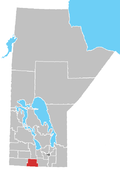
Location of Somerset in Manitoba
Coordinates: 49°24′44″N98°39′38″W / 49.41222°N 98.66056°W / 49.41222; -98.66056
Country Flag of Canada (Pantone).svg  Canada
Province Flag of Manitoba.svg  Manitoba
Region Pembina Valley Region
Census Division No. 4
Established1889
Incorporated1962
Government
   MP Branden Leslie
   MLA Lauren Stone
Time zone UTC−6 (CST)
  Summer (DST) UTC−5 (CDT)
Postal Code
R0G 2L0
Area code 204
NTS Map062G07
GNBC CodeGAZTM

Somerset is an unincorporated community recognized as a local urban district [1] in the Municipality of Lorne within the Canadian province of Manitoba that held village status prior to January 1, 2015.

Contents

Somerset has a clinic, gas station, restaurant, two churches, a drive-in, a hotel, a grain elevator, a high school, a curling rink, a skating rink and a library. The community is also home to the large concrete plant, Boulet Brothers Concrete.

Demographics

In the 2021 Census of Population conducted by Statistics Canada, Somerset had a population of 420 living in 195 of its 210 total private dwellings, a change of

Climate

Climate data for Somerset
MonthJanFebMarAprMayJunJulAugSepOctNovDecYear
Record high °C (°F)6
(43)
9
(48)
16.1
(61.0)
36.5
(97.7)
37
(99)
36
(97)
36.7
(98.1)
38.5
(101.3)
36.7
(98.1)
31.5
(88.7)
22.2
(72.0)
7
(45)
38.5
(101.3)
Mean daily maximum °C (°F)−12.4
(9.7)
−8.6
(16.5)
−1.5
(29.3)
9.6
(49.3)
18.2
(64.8)
22.3
(72.1)
24.5
(76.1)
24
(75)
17.8
(64.0)
10.2
(50.4)
−1.5
(29.3)
−10
(14)
7.7
(45.9)
Daily mean °C (°F)−17.3
(0.9)
−13.8
(7.2)
−6.5
(20.3)
3.8
(38.8)
11.5
(52.7)
16.2
(61.2)
18.4
(65.1)
17.5
(63.5)
11.7
(53.1)
4.8
(40.6)
−5.7
(21.7)
−14.5
(5.9)
2.2
(36.0)
Mean daily minimum °C (°F)−22.1
(−7.8)
−18.7
(−1.7)
−11.3
(11.7)
−2.1
(28.2)
4.7
(40.5)
10
(50)
12.2
(54.0)
11
(52)
5.5
(41.9)
−0.7
(30.7)
−9.9
(14.2)
−18.9
(−2.0)
−3.4
(25.9)
Record low °C (°F)−40.5
(−40.9)
−43
(−45)
−35.6
(−32.1)
−24.4
(−11.9)
−10
(14)
0
(32)
1.5
(34.7)
−2.5
(27.5)
−6.1
(21.0)
−20
(−4)
−36
(−33)
−39
(−38)
−43
(−45)
Average precipitation mm (inches)21.7
(0.85)
18.8
(0.74)
29
(1.1)
34.2
(1.35)
56.1
(2.21)
88.2
(3.47)
82.6
(3.25)
70.4
(2.77)
58.2
(2.29)
45.2
(1.78)
36.2
(1.43)
25.9
(1.02)
536
(21.1)
Source: Environment Canada [3]

Related Research Articles

Austin is an unincorporated community recognized as a local urban district in western Manitoba on the Trans-Canada Highway about 110 km (68 mi) west of Winnipeg. It is part of the Municipality of North Norfolk. It sits at the western edge of the table-flat Portage Plains, but to the south and west is surrounded by miles of low wooded hills known as the Carberry sandhills. The biggest attraction is the annual rodeo and Threshermen's Reunion held at the Manitoba Agricultural Museum the last four business days of July.

Snow Lake is a town in Manitoba, Canada, located 685 km north of Winnipeg at the end of Provincial Road 392. The main industry is, and always has been, mining; currently with one mine producing Zinc, and another lithium. The official Town of Snow Lake is a very large, overwhelmingly rural area that is centered about the urban community of Snow Lake, which lies very near its geographical center. The Town is as large in area as a typical rural municipality in the more southern parts of Manitoba.

Beatty is a village in the Canadian province of Saskatchewan within the Rural Municipality of Flett's Springs No. 429 and Census Division No. 15. The village is located approximately 13 km (8 mi) northwest of the City of Melfort. It is at the junction of Highway 3 and Highway 368. In 1925, Beatty was a Canadian National Railways (CNR) rail station on the Swan River - Prince Albert branch line. The area surrounding Beatty is predominantly farmland and the main source of employment is agriculture.

St. Claude is an unincorporated community recognized as a local urban district in the Rural Municipality of Grey within the Canadian province of Manitoba that held village status prior to January 1, 2015.

<span class="mw-page-title-main">Miami, Manitoba</span> Place in Manitoba, Canada

Miami is an unincorporated community recognized as a local urban district in southern Manitoba, Canada, which was formed in 1885. It supports a K-12 school and has a curling rink and a skating rink. It lies 100 kilometres southwest of Winnipeg in the Rural Municipality of Thompson.

<span class="mw-page-title-main">Baldur, Manitoba</span> Place in Manitoba, Canada

Baldur is an unincorporated community recognized as a local urban district in the Canadian province of Manitoba, located in the Rural Municipality of Argyle. Baldur is the largest community of the municipality, which is in southwestern Manitoba between Brandon and Portage la Prairie. The community is named after the Norse god Baldur.

<span class="mw-page-title-main">Alida, Saskatchewan</span> Village in Saskatchewan, Canada

Alidaə-LEE-də is a village in the Canadian province of Saskatchewan within the Rural Municipality of Reciprocity No. 32 and Census Division No. 1. The village is approximately 85 km (53 mi) east of the City of Estevan. Farming and oil are the major local industries. Several ghost towns are in the vicinity, including Nottingham to the east, Auburnton, to the west, and Cantal to the north-west. With the investment of oil and other industries, the area continues to grow.

<span class="mw-page-title-main">Togo, Saskatchewan</span> Village in Saskatchewan, Canada

Togo is a village in the Canadian province of Saskatchewan within the Rural Municipality of Cote No. 271 and Census Division No. 9. It is 800 metres west of the Manitoba border and approximately 72 km (45 mi) northeast of the City of Yorkton.

<span class="mw-page-title-main">Lorette, Manitoba</span> Place in Manitoba, Canada

Lorette is a local urban district in the Rural Municipality of Taché, located 25 km southeast of Winnipeg, in the province of Manitoba, Canada.

<span class="mw-page-title-main">Holland, Manitoba</span> City in Manitoba, Canada

Holland, Manitoba is an unincorporated community recognized as a local urban district in the Rural Municipality of Victoria, in Manitoba.

Notre Dame de Lourdes is an unincorporated community recognized as a local urban district in the Municipality of Lorne within the Canadian province of Manitoba that held village status prior to January 1, 2015. It is located within the Central Plains Region, 100 km southwest of Winnipeg. The community had a population of 683 inhabitants in the 2011 census, an increase of 16.0% from the 589 inhabitants during the 2006 census.

Reston is an unincorporated community recognized as a local urban district in southwestern Manitoba, located near the border of Saskatchewan on the west and North Dakota on the south. It is the largest community in the Rural Municipality of Pipestone, which also includes Sinclair, Cromer and Pipestone.

Semans is a village in the Canadian province of Saskatchewan within the Rural Municipality of Mount Hope No. 279 and Census Division No. 10. The village is located approximately 125 km north of the City of Regina and 195 km southeast of the City of Saskatoon.

<span class="mw-page-title-main">Rural Municipality of Coldwell</span> Rural municipality in Manitoba, Canada

The Rural Municipality of Coldwell is a rural municipality in the Interlake Region of the province of Manitoba in Western Canada. The principal community within the boundaries is Lundar.

<span class="mw-page-title-main">Rural Municipality of Mountain</span> Rural municipality in Manitoba, Canada

The Rural Municipality of Mountain is a rural municipality (RM) in the Parkland Region of Manitoba, western Canada.

<span class="mw-page-title-main">Bellis, Alberta</span> Hamlet in Alberta, Canada

Bellis is a hamlet in central Alberta, Canada within Smoky Lake County. Previously an incorporated municipality, Bellis dissolved from village status on January 1, 1946 to become part of the Municipal District of Vilna No. 575.

Windthorst is a village in the Canadian province of Saskatchewan within the Rural Municipality of Chester No. 125 and Census Division No. 5.

<span class="mw-page-title-main">Rural Municipality of Brokenhead</span> Rural municipality in Manitoba, Canada

The Rural Municipality of Brokenhead is a rural municipality (RM) in the Canadian province of Manitoba.

Miniota, Manitoba is an unincorporated community recognized as a local urban district in Prairie View Municipality, Manitoba, Canada. It is located northwest of Virden near the intersection of PTH 83 and PTH 24. The post office opened in 1885 on 36-13-27W. It was originally named Parkisimo and changed to its present name in 1900. It had two railways in its history: the Canadian Pacific Railway and the Grand Trunk Railway. Both had rail points about one mile apart and there was a Miniota Station on the latter.

<span class="mw-page-title-main">Municipality of Lorne</span> Rural municipality in Manitoba, Canada

The Municipality of Lorne is a rural municipality (RM) in the Canadian province of Manitoba.

References

  1. "Local Urban Districts Regulation". Government of Manitoba. April 23, 2016. Retrieved April 24, 2016.
  2. "Population and dwelling counts: Canada and designated places". Statistics Canada. February 9, 2022. Retrieved September 3, 2022.
  3. "Canadian Climate Normals 1971–2000". Environment Canada. Retrieved August 23, 2012.