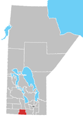
Division No. 4 (Pilot Mound) is a census division located within the Pembina Valley Region in the south-central region of the province of Manitoba, Canada. Unlike in some other provinces, census divisions do not reflect the organization of local government in Manitoba. These areas exist solely for the purposes of statistical analysis and presentation; they have no government of their own.
The major industry of the Pilot Mound is mixed farming and livestock. Also included in the division is the main reserve of the Swan Lake First Nation.
Kittson County is a county in the northwestern corner of the U.S. state of Minnesota along the Canada–US border, south of the Canadian province of Manitoba. As of the 2020 census, the population was 4,207. Its county seat is Hallock.
Turtle Mountain is a provincial electoral district in the Canadian province of Manitoba. It was created with the westward expansion of the province's boundaries in 1881, eliminated by redistribution in 1968, and re-established in 1979, formally returned to the electoral map with the provincial election of 1981, was dissolved for the 2011 election and returned once again for the 2019 Manitoba general election.
The Pembina Valley is an informal geographic region of the Canadian province of Manitoba. It is named for its major geographical feature, the Pembina Valley, which runs through the southwestern part of the region.
Swan River is a town in Manitoba, Canada. It is surrounded by the Municipality of Swan Valley West in the Swan River Valley region. Swan River acts as the hub to the surrounding communities of Minitonas, Benito, Bowsman, Birch River, and the other communities in the valley. As of 2016, Swan River was Manitoba's 16th largest in population, which was 4,014 as of the 2016 Canadian Census according to Statistics Canada, with an additional 2,829 people living in the surrounding rural municipality of Swan River.
Parkland is an informal geographic region of the Canadian province of Manitoba, located between Lakes Manitoba and Winnipegosis on the east and the Manitoba–Saskatchewan border on the west.
The Central Plains Region is an informal geographic region of the Canadian province of Manitoba located in the south central part of the Canadian province of Manitoba, directly west of Winnipeg.
Eastern Manitoba, or the Eastman Region, is an informal geographic region of the Canadian province of Manitoba. It is bounded on the north by the Winnipeg River and Lake Winnipeg, on the east by the Manitoba-Ontario border, on the south by the Canada–US border, and on the west by the Red River.
Manitoba is one of Canada's 10 provinces. It is the easternmost of the three Prairie provinces.
Division No. 19, also informally known as North East Manitoba, is a census division within the Province of Manitoba, Canada. Unlike in some other provinces, census divisions do not reflect the organization of local government in Manitoba. These areas exist solely for the purposes of statistical analysis and presentation; they have no government of their own.
Division No. 1 is a census division located within the Eastman Region of the Canadian province of Manitoba. Unlike in some other provinces, census divisions do not reflect the organization of local government in Manitoba. These areas exist solely for the purposes of statistical analysis and presentation; they have no government of their own.
Division No. 3 is a census division located within the Pembina Valley Region in the south-central region of the province of Manitoba, Canada. Unlike in some other provinces, census divisions do not reflect the organization of local government in Manitoba. These areas exist solely for the purposes of statistical analysis and presentation; they have no government of their own.
Division No. 6 (Virden) is a census division located within the Westman Region of south west Manitoba, located in the unceded territory of the Dakota people in Treaty 2. Unlike in some other provinces, census divisions do not reflect the organization of local government in Manitoba. These areas exist solely for the purposes of statistical analysis and presentation; they have no government of their own.
Census Division No. 8 is a census division located within the Central Plains Region of the Province of Manitoba, Canada. Unlike in some other provinces, census divisions do not reflect the organization of local government in Manitoba. These areas exist solely for the purposes of statistical analysis and presentation; they have no government of their own.
Census Division No. 20 is a census division located within the Parkland Region of the province of Manitoba. Unlike in some other provinces, census divisions do not reflect the organization of local government in Manitoba. These areas exist solely for the purposes of statistical analysis and presentation; they have no government of their own.
The Rural Municipality of Louise is a former rural municipality (RM) in the Canadian province of Manitoba. It was originally incorporated as a rural municipality on February 14, 1880. It ceased on January 1, 2015 as a result of its provincially mandated amalgamation with the Town of Pilot Mound and the Village of Crystal City to form the Municipality of Louise.
The Rural Municipality of Roblin is a former rural municipality (RM) in the Canadian province of Manitoba. It was originally incorporated as a rural municipality on November 15, 1902. It ceased on January 1, 2015 as a result of its provincially mandated amalgamation with the Village of Cartwright to form the Cartwright – Roblin Municipality.
Roland is a rural municipality located in the Pembina Valley Region of Manitoba, Canada. According to the Canada 2016 Census, it has a population of 1,129.
Thompson is a rural municipality in the Pembina Valley Region of Manitoba, Canada. It had a population of 1,259 according to the Canada 2006 Census.
The Swan Lake First Nation is a Saulteaux band government located along Swan Lake in the Pembina Valley Region of Manitoba, Canada.