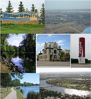
Portage la Prairie is a small city in the Central Plains Region of Manitoba, Canada. As of 2016, the population was 13,304 and the land area of the city was 24.68 square kilometres (9.53 sq mi).
Austin is an unincorporated community recognized as a local urban district in western Manitoba on the Trans-Canada Highway about 110 km (68 mi) west of Winnipeg. It is part of the Municipality of North Norfolk. It sits at the western edge of the table-flat Portage Plains, but to the south and west is surrounded by miles of low wooded hills known as the Carberry sandhills. The biggest attraction is the annual rodeo and Threshermen's Reunion held at the Manitoba Agricultural Museum the last four business days of July.

Portage—Lisgar is a federal electoral district in Manitoba, Canada, that has been represented in the House of Commons of Canada since 1997.
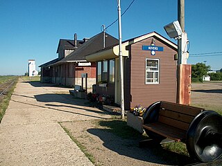
Rivers is an unincorporated urban community in the Riverdale Municipality within the Canadian province of Manitoba. It is located 40 kilometres (25 mi) northwest of Brandon, 473 metres (1,552 ft) above sea level. It is within the Westman Region. Agriculture, health and related businesses provide income for the community and area. Rivers has a population of 1,257 people in the 2016 census.

The Central Plains Region is an informal geographic region of the Canadian province of Manitoba located in the south central part of the Canadian province of Manitoba, directly west of Winnipeg.

Baldur is an unincorporated community recognized as a local urban district in the Canadian province of Manitoba, located in the Rural Municipality of Argyle. Baldur is the largest community of the municipality, which is in southwestern Manitoba between Brandon and Portage la Prairie. The community is named after the Norse god Baldur.
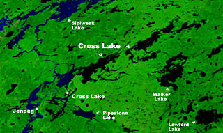
Cross Lake is a community in the Northern Region of the Canadian province of Manitoba, situated on the shores of the Nelson River where the river enters the namesake Cross Lake. An all-weather road, PR 374, connects the communities to PR 373 via the Kichi Sipi Bridge.

Rural Municipality of Cartier is a rural municipality in the Central Plains and Metro Regions of Manitoba, Canada. The municipality is bordered on the west by the RM of Portage la Prairie, to the east by the RM of Headingley, and to the north by the Assiniboine River. It is mainly flat rich farmland. Its main town is Elie.
Oakville, Manitoba is an unincorporated community recognized as a local urban district in Manitoba. It is located in the Rural Municipality of Portage la Prairie. Oakville is 56 km (35 mi) west of Winnipeg at the intersection of PTH 13 and PR 331.
Rapid City is an unincorporated community recognized as a local urban district that also once held town status in southwest Manitoba, Canada within the Rural Municipality of Oakview. It is located about 30 km north of Brandon. Rapid City is a farming community that is developed on the banks of the Little Saskatchewan River. The dam and reservoir in Rapid City were built by the province in 1961, the reservoir stores 200 acre-feet (250,000 m3) and provides a water supply and recreational facility for the community.

Gainsborough is a village in the Canadian province of Saskatchewan within the Rural Municipality of Argyle No. 1 and Census Division No. 1. A farming community, the village is located on Highway 18 in the southeastern corner of Saskatchewan. Gainsborough is approximately 6 km (3.7 mi) from the Manitoba border, and 19 km (12 mi) from the North Dakota, United States border. The first post office was established on April 1, 1884 as the community of Antler. On September 1, 1885, the name of the community changed to Gainsborough, after Gainsborough, Lincolnshire in England, which was the former home of J. J. Sadler, an early settler.

The Long Plain First Nation is an Ojibway and Dakota First Nations band government in Manitoba, Canada.

Division No. 19, also informally known as North East Manitoba, is a census division within the Province of Manitoba, Canada. Unlike in some other provinces, census divisions do not reflect the organization of local government in Manitoba. These areas exist solely for the purposes of statistical analysis and presentation; they have no government of their own.
Division No. 4 is a census division located within the Pembina Valley Region in the south-central region of the province of Manitoba, Canada. Unlike in some other provinces, census divisions do not reflect the organization of local government in Manitoba. These areas exist solely for the purposes of statistical analysis and presentation; they have no government of their own.
Division No. 6 (Virden) is a census division located within the Westman Region of south west Manitoba, Canada. Unlike in some other provinces, census divisions do not reflect the organization of local government in Manitoba. These areas exist solely for the purposes of statistical analysis and presentation; they have no government of their own.
Census Division No. 8 is a census division located within the Central Plains Region of the Province of Manitoba, Canada. Unlike in some other provinces, census divisions do not reflect the organization of local government in Manitoba. These areas exist solely for the purposes of statistical analysis and presentation; they have no government of their own.

Argyle is a rural municipality in the province of Manitoba in Western Canada. It was incorporated on 15 August 1881 and is named after John Campbell, 9th Duke of Argyll who was the fourth Governor General of Canada.
Harbour Round is a designated place in the Canadian province of Newfoundland and Labrador. It is east of Baie Verte.

Portage la Prairie is a rural municipality (RM) in the province of Manitoba in Western Canada. It surrounds the city of Portage la Prairie, Manitoba's fifth-largest city. Also within the borders of the municipality are the Dakota Plains First Nation and most of the Long Plain First Nation Indian reserves.
St. François Xavier is an unincorporated urban centre located in the Rural Municipality of St. François Xavier, Manitoba, Canada. It is located about 15 km west of the city of Winnipeg on the Assiniboine River.