
Grunthal is a local urban district in the Rural Municipality of Hanover, Manitoba, located 15 miles southwest of Steinbach, and about 50 minutes south of Winnipeg. It had a population of 1,680 in 2016.

Steinbach is a city located about 58 km (36 mi) south-east of Winnipeg, Manitoba, Canada. According to the Canada 2016 Census, Steinbach has a population of 15,829, making it the third-largest city in Manitoba and the largest community in the Eastman region. The city is bordered by the Rural Municipality of Hanover to the north, west, and south, and the Rural Municipality of La Broquerie to the east. Steinbach was first settled by Plautdietsch-speaking Mennonites from the Russian Empire in 1874, whose descendants continue to have a significant presence in the city today. Steinbach is found on the eastern edge of the Canadian Prairies, while Sandilands Provincial Forest is a short distance east of the city.

The Winnipeg Metropolitan Region is a metropolitan area in the Canadian province of Manitoba located in the Red River Valley in the southeast portion of the province of Manitoba, Canada. It contains the provincial capital of Winnipeg and 17 surrounding rural municipalities, cities, and towns.

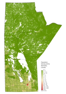
The Rural Municipality of Hanover is a rural municipality (RM) in southeastern Manitoba, Canada, located southeast of Winnipeg in Division No. 2.
Roseau River Anishinabe First Nation is a First Nation in southern Manitoba, Canada, situated around the Roseau River.

Parkland is an informal geographic region of the Canadian province of Manitoba, located between Lakes Manitoba and Winnipegosis on the east and the Manitoba–Saskatchewan border on the west.

Eastern Manitoba, or the Eastman Region, is an informal geographic region of the Canadian province of Manitoba. It is bounded on the north by the Winnipeg River and Lake Winnipeg, on the east by the Manitoba-Ontario border, on the south by the Canada–US border, and on the west by the Red River.
Mitchell is a local urban district located in the Rural Municipality of Hanover, Manitoba, Canada. It is located three kilometers west of Steinbach, Manitoba along Provincial Highway 52. The community has a population of 2,279 as of 2016, making Mitchell the 22nd largest population centre in Manitoba.

The Rural Municipality of Piney is a rural municipality in southeastern Manitoba, Canada, along the border with Minnesota in the United States.

The Sandilands Provincial Forest is a forest located within the southeastern area of Manitoba, Canada, and consists of thousands of acres of sand hills, forest, wetlands, and mostly unpopulated crown lands. Sandilands Provincial Forest covers close to 3,000 km2.
Manitoba is one of Canada's 10 provinces. It is the easternmost of the three Prairie provinces.

Division No. 1 is a census division located within the Eastman Region of the Canadian province of Manitoba. Unlike in some other provinces, census divisions do not reflect the organization of local government in Manitoba. These areas exist solely for the purposes of statistical analysis and presentation; they have no government of their own.

Division No. 7 is a census division located within the Westman Region in the south western area of the province of Manitoba, Canada. Unlike in some other provinces, census divisions do not reflect the organization of local government in Manitoba. These areas exist solely for the purposes of statistical analysis and presentation; they have no government of their own.
Census Division No. 20 is a census division located within the Parkland Region of the province of Manitoba. Unlike in some other provinces, census divisions do not reflect the organization of local government in Manitoba. These areas exist solely for the purposes of statistical analysis and presentation; they have no government of their own.
Census Division No. 12 is a census division located within the Eastman Region of the province of Manitoba, Canada. Unlike in some other provinces, census divisions do not reflect the organization of local government in Manitoba. These areas exist solely for the purposes of statistical analysis and presentation; they have no government of their own.
Census Division No. 17 (Dauphin) is a census division located within the Parklands Region of the province of Manitoba, Canada. Unlike in some other provinces, census divisions do not reflect the organization of local government in Manitoba. These areas exist solely for the purposes of statistical analysis and presentation; they have no government of their own.
Ste. Anne is a rural municipality in the Eastman Region of Manitoba, Canada, lying southeast of Winnipeg. The separately-administered town of Ste. Anne lies within the geographic borders of the municipality, in its northwestern part.
Southern Health-Santé Sud (SH-SS) is the governing body responsible for healthcare delivery and regulation for the eponymous health region in southern Manitoba—covering southeastern and south-central Manitoba, in particular.
Giroux is an unincorporated community located in the Rural Municipality of Ste. Anne, Manitoba, Canada.


