Beauharnois-Salaberry is a regional county municipality in the Montérégie region of Quebec, Canada. Its seat is Beauharnois.

Salaberry-de-Valleyfield is a city in southwestern Quebec, Canada, in the Regional County Municipality of Beauharnois-Salaberry. The population as of 2021 was 42,410.

Huntingdon is a small town in Huntingdon County in the Haut-Saint-Laurent Regional County Municipality and the Montérégie region of the province of Quebec, Canada. The population as of the 2021 Canadian census was 2,556. The town is 75 kilometres (47 mi) southwest of Montreal, and 15 kilometres (9.3 mi) from the border with New York State.
Elgin is a rural municipality in Quebec, Canada. The population as of the 2021 Canadian census was 389. It is located southwest of Huntingdon and bounded by the Trout and Chateauguay rivers and the Canada–United States border.

Stukely-Sud is a village of 950 people, part of the Memphrémagog Regional County Municipality in the Estrie region of Quebec, Canada.
St. Malo is a local urban district located in the Rural Municipality of De Salaberry, approximately 70 km south of The Forks, Winnipeg, Manitoba. Most of the community's residents are bilingual francophone of Métis or Québécois heritage.
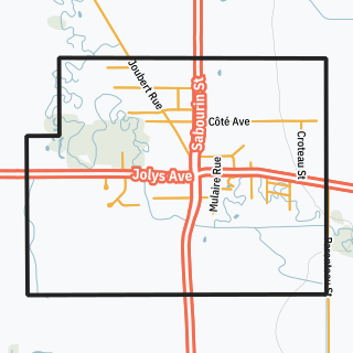
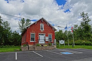
St-Pierre-Jolys is a village in the Canadian province of Manitoba, located 50 km (31 mi) southeast of Winnipeg on Highway 59 near the Rat River. It is surrounded by the Rural Municipality of De Salaberry, and the nearest communities to it are Steinbach, St. Malo, Morris and Niverville.

Saint-Bernard-de-Lacolle is a municipality in Les Jardins-de-Napierville Regional County Municipality, Quebec, Canada, located in the administrative area of Montérégie. Saint-Bernard-de-Lacolle was established as a municipality officially in 1855, and its population as of the Canada 2016 Census was 1,549. A major border crossing, Blackpool, is located where St-Bernard-de-Lacolle abuts the village of Champlain, New York, at the junction of Quebec Autoroute 15 and U.S. Interstate 87.
Saint-Patrice-de-Sherrington is a municipality in Les Jardins-de-Napierville Regional County Municipality in Quebec, Canada, situated in the Montérégie administrative region. The population as of the Canada 2021 Census was 1,963.

Beauharnois is a city located in the Beauharnois-Salaberry Regional County Municipality of southwestern Quebec, Canada, and is part of the Greater Montreal Area. The city's population as of the Canada 2021 Census was 13,638. It is home to the Beauharnois Hydroelectric Power Station, as well as the Beauharnois Lock of the Saint Lawrence Seaway.
Howick is the third smallest municipality in the Canadian province of Quebec, located in Le Haut-Saint-Laurent Regional County Municipality. The population as of the 2021 Canadian census was 850. Situated along the English River in the heart of the Chateauguay Valley, it is approximately 50 minutes southwest of Montreal and 20 minutes north of the Canada–United States border.

Saint-Zotique is a city located within the Vaudreuil-Soulanges Regional County Municipality in the Montérégie region located about 45 minutes west of Montreal, Quebec, Canada. It is named for Saint Zoticus of Comana.
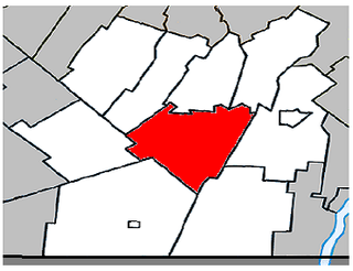
Sainte-Martine is a municipality in Beauharnois-Salaberry Regional County Municipality in the Montérégie region of Quebec, Canada. The population as of the 2021 Canadian census was 5,664. The municipality is made up of a large northern section and a small unattached southern area that was known as the municipality of Saint-Paul-de-Châteauguay until its merger with Sainte-Martine on September 9, 1999.
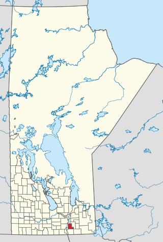
De Salaberry is a rural municipality in the province of Manitoba in western Canada. The administratively separate village of St-Pierre-Jolys and St. Malo Provincial Park lie within the geographical borders of the municipality. The municipality is named after Charles de Salaberry.

Les Coteaux is a municipality in Vaudreuil-Soulanges Regional County Municipality in the Montérégie region of Quebec, Canada. It is located north of the Saint Lawrence River and Salaberry-de-Valleyfield.

Saint-Édouard is a municipality in the Jardins de Napierville Regional County Municipality in Quebec, Canada, situated in the Montérégie administrative region. The population as of the Canada 2016 census was 1,321.

Saint-Mathieu is a municipality situated in the Montérégie administrative region in Quebec, Canada. The population as of the Canada 2016 Census was 2,156. It is part of the Roussillon Regional County Municipality.

Sainte-Barbe is a municipality of Quebec, located within Le Haut-Saint-Laurent Regional County Municipality in the Montérégie administrative region. The population as of the Canada 2021 Census was 1,609.

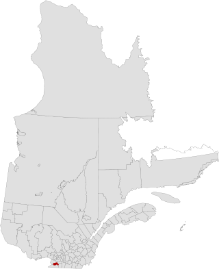
Saint-Étienne-de-Beauharnois is a municipality of Quebec, Canada, located within the Beauharnois-Salaberry Regional County Municipality in the Montérégie administrative region. The population as of the Canada 2021 Census was 1,099.

Lieutenant Colonel Charles-Michel d'Irumberry de Salaberry, CB was a Canadian military officer and statesman of the seigneurial class who served in various campaigns for the British Army. He won distinction for repelling the American advance on Montreal during the War of 1812.

