Rural Municipality of Hanover

Last updated

Rural Municipality of Hanover
Steinbachblumenortair2011.png
Steinbach (upper) and Blumenort (lower) as seen from the air.
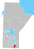
CAN MB Hanover.svg
The Location of the RM of Hanover in Manitoba
Coordinates: 49°26′36″N96°50′57″W / 49.44333°N 96.84917°W / 49.44333; -96.84917
CountryCanada
Province Manitoba
Region Eastman
IncorporatedMay 25, 1881 (1881-05-25)
Amalgamated1890
Government
   Reeve Jim Funk
Area
  Total730.44 km2 (282.02 sq mi)
Elevation
268 m (879 ft)
Population
  Total17,216
  Density23.6/km2 (61/sq mi)
Time zone UTC-6 (CST)
  Summer (DST) UTC-5 (CDT)
Website http://www.hanovermb.ca/

The Rural Municipality of Hanover is a rural municipality (RM) in southeastern Manitoba, Canada, located southeast of Winnipeg in Division No. 2.

Contents

It is Manitoba's most populous rural municipality and fourth-most populous municipality overall (behind the cities of Winnipeg, Brandon, and Steinbach) as of the 2021 census.
History

The area of Hanover was part of the traditional lands of the Ojibway-speaking natives. In the summer of 1871, the federal government signed treaties with these people and relocated them to reserves such as the Roseau River Anishinabe First Nation to the south and the Brokenhead Ojibway Nation to the north. [2] The Manitoba government set aside the East Reserve, slightly smaller than what is now the RM of Hanover, from the lands left behind for Plautdietsch-speaking Mennonites immigrants from the Russian empire. In 1873, these Mennonites signed an agreement with the Canadian government known as the Privilegium, which guaranteed land, freedom of religion, private schools, and military exemption. [3]

The East Reserve was divided into two municipalities in the early 1880s, as most of the southern Manitoba was organizing itself into new rural municipalities. [3] In 1880, the north part of the East Reserve became the Rural Municipality of Hespeler, named in honour of William Hespeler, who had brought many of the Mennonite immigrants to the area. The RM of Hanover, to the south, was established on 25 May 1881. The two municipalities shared administrative staff and merged into the single municipality of Hanover in 1890. [3]

Other settlers in the area were mainly French and Anglo-Saxons. [3]

The neighbouring city of Steinbach and town of Niverville were originally within Hanover but have since become separate urban municipalities. Steinbach was incorporated (as a Town) in 1946 and Niverville in 1969. These three municipalities now have a combined population of over 40,000 residents. [4] Hanover's municipal headquarters were located in Steinbach until a new office building near Mitchell was constructed in 2001. [5]

Demographics

Hanover is the province's most populated rural municipality, ahead of the Rural Municipality of Springfield, and fourth-most populated municipality overall, slightly behind the City of Steinbach. In the 2021 Census of Population conducted by Statistics Canada, Hanover had a population of 17,216 living in 5,141 of its 5,305 total private dwellings, a change of

Historical population [7]
YearPop.±%
18811,000    
18912,300+130.0%
18962,614+13.7%
19013,438+31.5%
19113,884+13.0%
19214,795+23.5%
19315,833+21.6%
19418,190+40.4%
19516,570−19.8%
19566,696+1.9%
19616,771+1.1%
19666,739−0.5%
YearPop.±%
19716,237−7.4%
19766,645+6.5%
19817,428+11.8%
19868,033+8.1%
19918,905+10.9%
19969,833+10.4%
200110,789+9.7%
200611,871+10.0%
201114,026+18.2%
201615,540+10.8%
202117,216+10.8%
Panethnic groups in the Rural Municipality of Hanover (2001−2021)
Panethnic group2021 [8] 2016 [9] 2011 [10] 2006 [11] 2001 [12]
Pop. %Pop.%Pop.%Pop.%Pop.%
European [lower-alpha 1] 14,91514,44013,01511,45510,460
Indigenous 1,410995740305185
Southeast Asian [lower-alpha 2] 265251500
African 220105453510
Latin American 9550551515
South Asian 6510351010
East Asian [lower-alpha 3] 452015030
Middle Eastern [lower-alpha 4] 4510000
Other/multiracial [lower-alpha 5] 2010000
Total responses17,13015,66013,93511,81510,705
Total population17,21615,73314,02611,87110,789
Note: Totals greater than 100% due to multiple origin responses

Transportation

Hanover is served by three provincial highways: PTH 52, PTH 12, and PTH 59; the latter two link the municipality with the City of Winnipeg, the provincial capital. There are no major rivers or rail lines running through Hanover; however, the Canadian Pacific Railway's Emerson subdivision forms a portion of the municipality's boundary with the Rural Municipality of Ritchot. [13]

The Steinbach South Airport is a privately-run airport located within municipal boundaries near Steinbach. [14]

Communities

Local urban districts
Other communities

Notes

  1. Statistic includes all persons that did not make up part of a visible minority or an indigenous identity.
  2. Statistic includes total responses of "Filipino" and "Southeast Asian" under visible minority section on census.
  3. Statistic includes total responses of "Chinese", "Korean", and "Japanese" under visible minority section on census.
  4. Statistic includes total responses of "West Asian" and "Arab" under visible minority section on census.
  5. Statistic includes total responses of "Visible minority, n.i.e." and "Multiple visible minorities" under visible minority section on census.

Related Research Articles

<span class="mw-page-title-main">Golden Horseshoe</span> Secondary region in Ontario, Canada

The Golden Horseshoe is a secondary region of Southern Ontario, Canada, which lies at the western end of Lake Ontario, with outer boundaries stretching south to Lake Erie and north to Lake Scugog, Lake Simcoe and Georgian Bay of Lake Huron. The region is the most densely populated and industrialized in Canada. Based on the 2021 census, with a population of 7,759,635 people in its core and 9,765,188 in its greater area, the Golden Horseshoe accounts for over 20 percent of the population of Canada and more than 54 percent of Ontario's population. It is part of the Quebec City–Windsor Corridor, itself part of the Great Lakes megalopolis.

Grunthal is a local urban district in the Rural Municipality of Hanover, Manitoba, located 24 kilometers southwest of Steinbach, and about 50 minutes south of Winnipeg. It had a population of 1,680 in 2016.

<span class="mw-page-title-main">Dauphin, Manitoba</span> City in Manitoba, Canada

Dauphin is a city in Manitoba, Canada, with a population of 8,368 as of the 2021 Canadian Census. The community is surrounded by the Rural Municipality of Dauphin. The city takes its name from Lake Dauphin and Fort Dauphin, which were named by explorer Pierre Gaultier de La Vérendrye in honour of the Dauphin of France, the heir to the French throne. Dauphin is Manitoba's ninth largest community and serves as a hub to the province's Parkland Region.

<span class="mw-page-title-main">Steinbach, Manitoba</span> City in Manitoba, Canada

Steinbach is the third-largest city in the province of Manitoba, Canada and, with a population of 17,806, the largest community in the Eastman region. The city, located about 58 km (36 mi) southeast of the provincial capital of Winnipeg, is bordered by the Rural Municipality of Hanover to the north, west, and south, and the Rural Municipality of La Broquerie to the east. Steinbach was first settled by Plautdietsch-speaking Mennonites from Ukraine in 1874, whose descendants continue to have a significant presence in the city today. Steinbach is found on the eastern edge of the Canadian Prairies, while Sandilands Provincial Forest is a short distance east of the city.

<span class="mw-page-title-main">Winkler, Manitoba</span> City in Manitoba, Canada

Winkler is a city in Manitoba, Canada with a population of 13,745, making it the 4th largest city in Manitoba, as of the 2021 Canadian census. It is located in southern Manitoba, surrounded by the Rural Municipality of Stanley, about one hundred kilometres southwest of Winnipeg and thirteen kilometres east of its "twin city" Morden. As the largest city in the Pembina Valley, it serves as a regional hub for commerce, agriculture and industry. Winkler is the third-fastest growing city in the province after Morden and Steinbach.

<span class="mw-page-title-main">Niverville, Manitoba</span> Place in Manitoba, Canada

Niverville is a town in the Eastman Region, Manitoba, Canada. The town lies between the northwest corner of the Rural Municipality of Hanover and the southeastern portion of the Rural Municipality of Ritchot. Niverville's population as of the 2021 census is 5,947, the largest town and 10th-largest community in Manitoba.

<span class="mw-page-title-main">Portage—Lisgar</span> Federal electoral district in Manitoba, Canada

Portage—Lisgar is a federal electoral district in Manitoba, Canada, that has been represented in the House of Commons of Canada since 1997.

<span class="mw-page-title-main">Winnipeg Metropolitan Region</span> Metropolitan area in Manitoba, Canada

The Winnipeg Metropolitan Region is a metropolitan area in the Canadian province of Manitoba located in the Red River Valley in the southeast portion of the province of Manitoba, Canada. It contains the provincial capital of Winnipeg and 17 surrounding rural municipalities, cities, and towns.

<span class="mw-page-title-main">Rural Municipality of East St. Paul</span> Rural municipality in Manitoba, Canada

East St. Paul is a rural municipality (RM) in Manitoba, Canada. It is located north-east of and adjacent to the city of Winnipeg, and is part of the Winnipeg Metropolitan Area. The municipality was formed on 3 November 1915 when the municipality of St. Paul (1888-1914) was subdivided into West St. Paul and East St. Paul, with the Red River acting as the dividing line.

<span class="mw-page-title-main">Rural Municipality of St. Andrews</span> Rural municipality in Manitoba, Canada

St. Andrews is a rural municipality (RM) in Manitoba, Canada. It lies west of the Red River; its southern border is approximately 8 kilometres (5.0 mi) north of Winnipeg.

<span class="mw-page-title-main">Rural Municipality of St. Clements</span> Rural municipality in Manitoba, Canada

St. Clements is a rural municipality (RM) in Manitoba, Canada. It is located to the north-east of Winnipeg, stretching from East St. Paul and Birds Hill Provincial Park in the south to Lake Winnipeg and Grand Beach Provincial Park to the north. The Red River demarcates the western boundary of the municipality. St. Clements contains the communities of East Selkirk, and Lockport east of the Red River. It almost completely surrounds the Brokenhead 4 Indian reserve, with the exception of a small lakefront on Lake Winnipeg.

<span class="mw-page-title-main">Rural Municipality of Taché</span> Rural municipality in Manitoba, Canada

Taché is a rural municipality in Manitoba, Canada, incorporated in 1880.

<span class="mw-page-title-main">Rural Municipality of Springfield</span> Rural municipality in Manitoba, Canada

Springfield is a rural municipality (RM) in Manitoba, Canada. It stretches from urban industrial development on the eastern boundary of the city of Winnipeg, through urban, rural residential, agricultural and natural landscapes, to the Agassiz Provincial Forest on the municipality's eastern boundary. Birds Hill Provincial Park nestles into the north-western corner of Springfield.

<span class="mw-page-title-main">Rural Municipality of Macdonald</span> Rural Municipality in Southern Manitoba

Macdonald is a rural municipality lying adjacent to the southwest side of Winnipeg, Manitoba, Canada. It is part of the Winnipeg Metro Region, but is not part of the smaller Winnipeg census metropolitan area. Macdonald's population as of the 2016 census was 7,162.

<span class="mw-page-title-main">Rural Municipality of Rockwood</span> Rural Municipality in Manitoba, Canada

Rockwood is a rural municipality (RM) lying north of Winnipeg, Manitoba, Canada. It is part of the Winnipeg Metro Region and had a 2021 census population of 8,440. The independently governed towns of Stonewall and Teulon are both enclaved within Rockwood.

<span class="mw-page-title-main">St. Adolphe, Manitoba</span> Place in Manitoba, Canada

St. Adolphe, or Saint Adolphe, originally called Pointe-Coupée, is a community in the Rural Municipality of Ritchot, Manitoba, Canada. It is located along the east bank of the Red River, approximately 12 kilometres south of Winnipeg.

<span class="mw-page-title-main">Demographics of Manitoba</span>

Manitoba is one of Canada's 10 provinces. It is the easternmost of the three Prairie provinces.

<span class="mw-page-title-main">Rural Municipality of Stanley</span> Rural municipality in Manitoba, Canada

Stanley is a rural municipality (RM) in the province of Manitoba in Western Canada. It is located in the southern part of the province, along its border with the state of North Dakota in the United States. Since 1876, the area made up part of the Mennonite West Reserve. The municipality has a population of 8,969 as of the 2016 Canada Census. The cities of Winkler and Morden lie geographically within the municipality but are separate urban municipalities.

<span class="mw-page-title-main">Saskatoon metropolitan area</span> Metropolitan area in Saskatchewan, Canada

The Saskatoon region is the greater metropolitan area of Saskatoon, Saskatchewan. As of 2021 the Statistics Canada estimates the region's population to be 317,480 people.

<span class="mw-page-title-main">Dauphin—Swan River—Neepawa</span> Federal electoral district in Manitoba, Canada

Dauphin—Swan River—Neepawa is a federal electoral district in Manitoba. It encompasses a portion of Manitoba previously included in the electoral districts of Dauphin—Swan River—Marquette, Brandon—Souris and Portage—Lisgar.

References

  1. "Census Profile, 2021 Census of Population, Rural Municipality of Hanover". Statistics Canada. February 9, 2022. Retrieved February 9, 2022.
  2. "History and Heritage of Roseau River First Nation" . Retrieved July 1, 2010.
  3. 1 2 3 4 "RM of Hanover History". RM of Hanover History. Archived from the original on May 30, 2010. Retrieved July 11, 2010.
  4. "The Town Of Niverville Celebrates 50th Anniversary". SteinbachOnline.com. September 9, 2019.
  5. "Hanover office officially opens". The Carillon News. April 5, 2001.
  6. "Population and dwelling counts: Canada, provinces and territories, and census subdivisions (municipalities), Manitoba". Statistics Canada. February 9, 2022. Retrieved February 20, 2022.
  7. Goldsborough, Gordon (February 11, 2022). "Manitoba Communities: Hanover (Rural Municipality)". Manitoba Historical Society. Retrieved March 27, 2022.
  8. Government of Canada, Statistics Canada (October 26, 2022). "Census Profile, 2021 Census of Population". www12.statcan.gc.ca. Retrieved April 29, 2023.
  9. Government of Canada, Statistics Canada (October 27, 2021). "Census Profile, 2016 Census". www12.statcan.gc.ca. Retrieved April 29, 2023.
  10. Government of Canada, Statistics Canada (November 27, 2015). "NHS Profile". www12.statcan.gc.ca. Retrieved April 29, 2023.
  11. Government of Canada, Statistics Canada (August 20, 2019). "2006 Community Profiles". www12.statcan.gc.ca. Retrieved April 29, 2023.
  12. Government of Canada, Statistics Canada (July 2, 2019). "2001 Community Profiles". www12.statcan.gc.ca. Retrieved April 29, 2023.
  13. "RM of Hanover Living". RM of Hanover. Retrieved May 25, 2022.
  14. "New show filming scenes at Harv's Air". steinbachonline.com. November 9, 2022.