Rural Municipality of Whitehead

Last updated

Rural Municipality of Whitehead
CAN MB Whitehead.svg
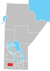
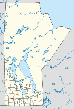
Location of the RM of Whitehead in Manitoba
Coordinates: 49°47′53″N100°15′27″W / 49.79806°N 100.25750°W / 49.79806; -100.25750 Coordinates: 49°47′53″N100°15′27″W / 49.79806°N 100.25750°W / 49.79806; -100.25750
CountryCanada
Province Manitoba
Area
  Land577.60 km2 (223.01 sq mi)
Population
 (2021) [1]
  Total1,679
Time zone UTC-6 (CST)
  Summer (DST) UTC-5 (CDT)
Area codes 204 and 431

Whitehead is a rural municipality (RM) in the province of Manitoba in Western Canada. It is west of Brandon and the principle communities within its boundaries are Kemnay and Alexander.

Contents

It became a municipality on 22 December 1883 and was named for Joseph Whitehead, a railway contractor who was active in the area during the 1880s.

Communities

Demographics

In the 2021 Census of Population conducted by Statistics Canada, Whitehead had a population of 1,679 living in 612 of its 645 total private dwellings, a change of

Related Research Articles

<span class="mw-page-title-main">Rural Municipality of Alexander</span> Rural municipality in Manitoba, Canada

The Rural Municipality of Alexander is a rural municipality in the Eastman Region of Manitoba, Canada. The town of Powerview-Pine Falls lies adjacent to the municipality, as does the Sagkeeng First Nation Indian reserve.

<span class="mw-page-title-main">Rural Municipality of Reynolds</span> Rural municipality in Manitoba, Canada

The Rural Municipality of Reynolds is a rural municipality (RM) in southeastern Manitoba, Canada.

<span class="mw-page-title-main">Rural Municipality of Macdonald</span> Rural Municipality in southern Manitoba

Macdonald is a rural municipality lying adjacent to the southwest side of Winnipeg, Manitoba, Canada. It is part of the Winnipeg Metro Region, but is not part of the smaller Winnipeg census metropolitan area. Macdonald's population as of the 2016 census was 7,162.

Powerview-Pine Falls is a town in the Canadian province of Manitoba, with a population of 1,314 at the 2011 census, up 1.54% from 1,294 at the 2006 census and down 7.57% from 1,400 during the 2001 census.

<span class="mw-page-title-main">Rural Municipality of Argyle No. 1</span> Rural Municipality in Saskatchewan, Canada

The Rural Municipality of Argyle No. 1 is a rural municipality (RM) in the Canadian province of Saskatchewan within Census Division No. 1 and SARM Division No. 1. It is located in the southeast corner of the province along Highway 18.

<span class="mw-page-title-main">Rural Municipality of Victoria</span> Rural municipality in Manitoba, Canada

The Rural Municipality of Victoria is a rural municipality (RM) located in south-central Manitoba, north-east of Glenboro. The RM was established in 1902 and named for Queen Victoria. In its westernmost part, the RM contains parts of Manitoba's Spruce Woods Provincial Forest and Spruce Woods Provincial Park.

<span class="mw-page-title-main">Rural Municipality of Grahamdale</span> Rural municipality in Manitoba, Canada

Grahamdale is a rural municipality (RM) in the province of Manitoba in Western Canada. It lies in the Interlake Region. It was incorporated as a Local Government District (LGD) on 1 January 1945, and became a Rural Municipality in 1997.

<span class="mw-page-title-main">Rural Municipality of Dufferin</span> Rural municipality in Manitoba, Canada

Dufferin is a rural municipality in the province of Manitoba in Western Canada. The separately administered town of Carman lies near its centre.

<span class="mw-page-title-main">Rural Municipality of Stanley</span> Rural municipality in Manitoba, Canada

Stanley is a rural municipality (RM) in the province of Manitoba in Western Canada. It is located in the southern part of the province, along its border with the state of North Dakota in the United States. Since 1876, the area made up part of the Mennonite West Reserve. The municipality has a population of 8,969 as of the 2016 Canada Census. The cities of Winkler and Morden lie geographically within the municipality but are separate urban municipalities.

<span class="mw-page-title-main">Rural Municipality of Argyle</span> Rural municipality in Manitoba, Canada

Argyle is a rural municipality in the province of Manitoba in Western Canada. It was incorporated on 15 August 1881 and is named after John Campbell, 9th Duke of Argyll who was the fourth Governor General of Canada.

<span class="mw-page-title-main">Rural Municipality of Morris</span> Rural municipality in Manitoba, Canada

Morris is a rural municipality (RM) in the province of Manitoba in Western Canada. The town of Morris, a separate urban municipality, is located in the southeastern corner of the RM.

<span class="mw-page-title-main">Rural Municipality of Mountain</span> Rural municipality in Manitoba, Canada

The Rural Municipality of Mountain is a rural municipality (RM) in the Parkland Region of Manitoba, western Canada.

<span class="mw-page-title-main">Rural Municipality of Portage la Prairie</span> Rural municipality in Manitoba, Canada

Portage la Prairie is a rural municipality (RM) in the province of Manitoba in Western Canada. It surrounds the city of Portage la Prairie, Manitoba's fifth-largest city. Also within the borders of the municipality are the Dakota Plains First Nation and most of the Long Plain First Nation Indian reserves.

<span class="mw-page-title-main">Rural Municipality of Stuartburn</span> Rural municipality in Manitoba, Canada

Stuartburn is a rural municipality (RM) located in the Eastman Region of Manitoba, Canada. It had a population of 1,629 according to the Canada 2006 Census.

<span class="mw-page-title-main">Rural Municipality of Thompson</span> Rural municipality in Manitoba, Canada

Thompson is a rural municipality (RM) in the Pembina Valley Region of Manitoba, Canada. It had a population of 1,259 according to the Canada 2006 Census.

<span class="mw-page-title-main">Municipality of Killarney-Turtle Mountain</span> Rural municipality in Manitoba, Canada

Killarney-Turtle Mountain is a rural municipality (RM) located in the Westman Region of Manitoba, Canada. It is located to the immediate north of the Canada–United States border opposite Rollete and Towner Counties, North Dakota.

<span class="mw-page-title-main">Rural Municipality of Elton</span> Rural municipality in Manitoba, Canada

Elton is a rural municipality in the Canadian province of Manitoba, located to the north of the city of Brandon. The community was incorporated in 1883, and its first officials took office the following year.

For the municipality, see: the Rural Municipality of Alexander

<span class="mw-page-title-main">Rural Municipality of Whitemouth</span> Rural municipality in Manitoba, Canada

The Rural Municipality of Whitemouth is a rural municipality (RM) located in southeastern Manitoba.

References

  1. 1 2 "Population and dwelling counts: Canada, provinces and territories, and census subdivisions (municipalities), Manitoba". Statistics Canada. 9 February 2022. Retrieved 20 February 2022.