Gimli is a rural municipality located in the Interlake Region of south-central Manitoba, Canada, on the western shore of Lake Winnipeg. It is about 75 kilometres (47 mi) north of the provincial capital Winnipeg. The rural municipality's population in the Canada 2016 Census was 6,181, making it the 12th largest rural municipality by population. The RM of Gimli has an area of 318.75 square kilometres (123.07 sq mi), making it the sixth smallest rural municipality by area.

Carberry is a town in southwestern Manitoba, Canada. It is situated 3 kilometres south of the Trans-Canada Highway on Highway 5 in the Municipality of North Cypress – Langford, and has a population of 1,738 people.

Springfield is a rural municipality (RM) in Manitoba, Canada. It stretches from urban industrial development on the eastern boundary of the City of Winnipeg, through urban, rural residential, agricultural and natural landscapes, to the Agassiz Provincial Forest on the municipality's eastern boundary. Birds Hill Provincial Park nestles into the northwestern corner of Springfield.
The Rural Municipality of Glenwood is a former rural municipality (RM) in the Canadian province of Manitoba. It was originally incorporated as a rural municipality on December 22, 1883. It ceased on January 1, 2015 as a result of its provincially mandated amalgamation with the Town of Souris to form the Municipality of Souris – Glenwood.

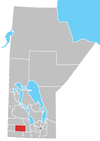
The Rural Municipality of Victoria is located in south-central Manitoba, north-east of Glenboro. The RM was established in 1902 and named for Queen Victoria. In its westernmost part, the RM contains parts of Manitoba's Spruce Woods Provincial Forest and Spruce Woods Provincial Park.
The Rural Municipality of Arthur is a former rural municipality (RM) in the Canadian province of Manitoba. It was originally incorporated as a rural municipality on December 22, 1883. It ceased on January 1, 2015 as a result of its provincially mandated amalgamation with the RM of Albert and the RM of Edward to form the Municipality of Two Borders.
The Rural Municipality of Brenda is a former rural municipality (RM) in the Canadian province of Manitoba. It was originally incorporated as a rural municipality on December 22, 1883. It ceased on January 1, 2015 as a result of its provincially mandated amalgamation with the Village of Waskada to form the Municipality of Brenda – Waskada.
The Rural Municipality of Edward is a former rural municipality (RM) in the Canadian province of Manitoba. It was originally incorporated as a rural municipality on December 1, 1905. It ceased on January 1, 2015 as a result of its provincially mandated amalgamation with the RM of Albert and the RM of Arthur to form the Municipality of Two Borders.
The Rural Municipality of Glenella is a former rural municipality (RM) in the Canadian province of Manitoba. It was originally incorporated as a rural municipality on April 10, 1920. It ceased on January 1, 2015 as a result of its provincially mandated amalgamation with the RM of Lansdowne to form the Municipality of Glenella – Lansdowne.
The Rural Municipality of Harrison is a former rural municipality (RM) in the Canadian province of Manitoba. It was originally incorporated as a rural municipality on December 22, 1883. It ceased on January 1, 2015 as a result of its provincially mandated amalgamation with the RM of Park to form the Municipality of Harrison Park.
The Rural Municipality of Langford is a former rural municipality (RM) in the Canadian province of Manitoba. It was originally incorporated as a rural municipality on November 1, 1890. It ceased on January 1, 2015 as a result of its provincially mandated amalgamation with the RM of North Cypress to form the Municipality of North Cypress – Langford.
The Rural Municipality of Louise is a former rural municipality (RM) in the Canadian province of Manitoba. It was originally incorporated as a rural municipality on February 14, 1880. It ceased on January 1, 2015 as a result of its provincially mandated amalgamation with the Town of Pilot Mound and the Village of Crystal City to form the Municipality of Louise.
The Rural Municipality of Minto is a former rural municipality (RM) in the Canadian province of Manitoba. It was originally incorporated as a rural municipality on November 15, 1902. It ceased on January 1, 2015 as a result of its provincially mandated amalgamation with the RM of Odanah to form the Rural Municipality of Minto – Odanah.
The Rural Municipality of Morton is a former rural municipality (RM) in the Canadian province of Manitoba. It was originally incorporated as a rural municipality on November 1, 1890. It ceased on January 1, 2015 as a result of its provincially mandated amalgamation with the Town of Boissevain to form the Municipality of Boissevain – Morton.

The Rural Municipality of Pembina is a former rural municipality (RM) in the Canadian province of Manitoba. It was originally incorporated as a rural municipality on November 1, 1890. It ceased on January 1, 2015 as a result of its provincially mandated amalgamation with the Town of Manitou to form the Municipality of Pembina.
The Rural Municipality of Shell River was a rural municipality (RM) in the Canadian province of Manitoba. It was incorporated as a rural municipality on December 22, 1883. On January 1, 2015 it was amalgamated as a result a provincial government mandate with the RM of Hillsburg and the Town of Roblin to form the Municipality of Hillsburg – Roblin – Shell River.
The Rural Municipality of Park is a former rural municipality (RM) in the Canadian province of Manitoba. It was originally incorporated as a rural municipality on January 1, 1997. It ceased on January 1, 2015 as a result of its provincially mandated amalgamation with the RM of Harrison to form the Municipality of Harrison Park.
The Rural Municipality of South Cypress is a former rural municipality (RM) in the Canadian province of Manitoba. It was originally incorporated as a rural municipality on December 22, 1883. It ceased on January 1, 2015 as a result of its provincially mandated amalgamation with the Village of Glenboro to form the Municipality of Glenboro – South Cypress.
Manitoba Provincial Road 353 is a provincial road in southwestern region of the Canadian province of Manitoba.
The Municipality of North Cypress – Langford is a rural municipality (RM) in the Canadian province of Manitoba. It is located northeast and east of the City of Brandon. The Town of Neepawa borders the RM to the north. Canadian Forces Base Shilo is also adjacent to the RM.