Related Research Articles

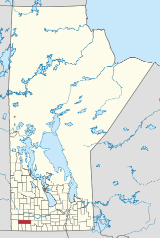
The Rural Municipality of Sifton is a rural municipality (RM) in the south-west portion of the Canadian province of Manitoba.
The Rural Municipality of Arthur is a former rural municipality (RM) in the Canadian province of Manitoba. It was originally incorporated as a rural municipality on December 22, 1883. It ceased on January 1, 2015 as a result of its provincially mandated amalgamation with the RM of Albert and the RM of Edward to form the Municipality of Two Borders.
The Rural Municipality of Brenda is a former rural municipality (RM) in the Canadian province of Manitoba. It was originally incorporated as a rural municipality on December 22, 1883. It ceased on January 1, 2015 as a result of its provincially mandated amalgamation with the Village of Waskada to form the Municipality of Brenda – Waskada.
The Rural Municipality of Harrison is a former rural municipality (RM) in the Canadian province of Manitoba. It was originally incorporated as a rural municipality on December 22, 1883. It ceased on January 1, 2015 as a result of its provincially mandated amalgamation with the RM of Park to form the Municipality of Harrison Park.
The Rural Municipality of Morton is a former rural municipality (RM) in the Canadian province of Manitoba. It was originally incorporated as a rural municipality on November 1, 1890. It ceased on January 1, 2015, as a result of its provincially mandated amalgamation with the Town of Boissevain to form the Municipality of Boissevain – Morton.
The Rural Municipality of Oakland is a former rural municipality (RM) in the Canadian province of Manitoba. It was originally incorporated as a rural municipality on December 22, 1883. It ceased on January 1, 2015 as a result of its provincially mandated amalgamation with the Village of Wawanesa to form the Municipality of Oakland – Wawanesa.
The Rural Municipality of Wallace is a former rural municipality (RM) in the Canadian province of Manitoba. It was originally incorporated as a rural municipality on December 22, 1883. It ceased on January 1, 2015 as a result of its provincially mandated amalgamation with the RM of Woodworth and the Village of Elkhorn to form the Rural Municipality of Wallace – Woodworth.
The Rural Municipality of Whitewater is a former rural municipality (RM) in the Canadian province of Manitoba. It was originally incorporated as a rural municipality on December 22, 1883. It ceased on January 1, 2015 as a result of its provincially mandated amalgamation with the RM of Cameron and the Town of Hartney to form the Municipality of Grassland.
The Rural Municipality of Winchester is a former rural municipality (RM) in the Canadian province of Manitoba. It was originally incorporated as a rural municipality on November 1, 1890. It ceased on January 1, 2015 as a result of its provincially mandated amalgamation with the Town of Deloraine to form the Municipality of Deloraine – Winchester.
The Rural Municipality of Woodworth is a former rural municipality (RM) in the Canadian province of Manitoba. It was originally incorporated as a rural municipality on December 22, 1883. It ceased on January 1, 2015 as a result of its provincially mandated amalgamation with the RM of Wallace and the Village of Elkhorn to form the Rural Municipality of Wallace – Woodworth.
The Rural Municipality of Ethelbert is a former rural municipality (RM) in the Canadian province of Manitoba. It was originally incorporated as a rural municipality on March 1, 1905. It ceased on January 1, 2015 as a result of its provincially mandated amalgamation with the Town of Ethelbert to form the Municipality of Ethelbert.

The Rural Municipality of North Cypress is a former rural municipality (RM) in the Canadian province of Manitoba. It was originally incorporated as a rural municipality on January 1, 1883. It ceased on January 1, 2015 as a result of its provincially mandated amalgamation with the RM of Langford to form the Municipality of North Cypress – Langford.
The Rural Municipality of North Norfolk is a former rural municipality (RM) in the Canadian province of Manitoba. It was originally incorporated as a rural municipality on January 1, 1883. It ceased on January 1, 2015 as a result of its provincially mandated amalgamation with the Town of MacGregor to form the Municipality of North Norfolk.
The Rural Municipality of South Norfolk is a former rural municipality (RM) in the Canadian province of Manitoba. It was originally incorporated as a rural municipality on December 22, 1883. It ceased on January 1, 2015, as a result of its provincially mandated amalgamation with the Town of Treherne to form the Municipality of Norfolk Treherne.
The Rural Municipality of Franklin is a former rural municipality (RM) in the Canadian province of Manitoba. It was incorporated on December 22, 1883. It ceased on January 1, 2015 as a result of a provincially mandated amalgamation with the Town of Emerson to form the Municipality of Emerson – Franklin.
The Rural Municipality of Saskatchewan is a former rural municipality (RM) in the Canadian province of Manitoba. It was originally incorporated as a rural municipality on December 22, 1883. It ceased on January 1, 2015 as a result of its provincially mandated amalgamation with the RM of Blanshard and the Town of Rapid City to form the Rural Municipality of Oakview.
The Municipality of Grassland is a rural municipality (RM) in the Canadian province of Manitoba.

The Municipality of Souris-Glenwood is a rural municipality (RM) in the Canadian province of Manitoba.
References
- ↑ "Manitoba's Municipal History: Rural Municipalities and Local Government Districts". The Manitoba Historical Society. September 21, 2014. Retrieved January 2, 2015.
- ↑ "Manitoba's Municipal History: Municipal Amalgamations (2015)". The Manitoba Historical Society. December 1, 2014. Retrieved January 2, 2015.
- Geographic Names of Manitoba (pg. 94) - the Millennium Bureau of Canada
- Map of Glenwood R.M. at Statcan
49°37′15″N100°15′29″W / 49.62083°N 100.25806°W
| Cities |  | ||
|---|---|---|---|
| Towns |
| ||
| Villages |
| ||
| Rural municipalities |
| ||
| Unincorporated communities | |||