Rural Municipality of Piney

Last updated

Piney
Rural municipality
Rural Municipality of Piney
CAN MB Piney.svg
Location of the Rural Municipality of Piney in Manitoba
Coordinates: 49°12′25″N95°50′00″W / 49.20694°N 95.83333°W / 49.20694; -95.83333
CountryCanada
Province Manitoba
Census Division 1
Government
   Reeve Wayne Anderson
Area
  Land2,433.10 km2 (939.43 sq mi)
Population
 (2021) [1]
  Total1,726
  Density0.7/km2 (2/sq mi)
Area code 204
Website rmofpiney.mb.ca

The Rural Municipality of Piney is a rural municipality (RM) in southeastern Manitoba, Canada, along the border with Minnesota in the United States.

Contents

Geography

According to Statistics Canada, the municipality has a land area of 2,433.77 km2. It is bordered by the rural municipalities of Stuartburn, La Broquerie, and Reynolds, as well as the Buffalo Point 36 Indian reserve and an unorganized part of the province (Division No. 1, Unorganized, Manitoba).

The municipality borders Roseau County in the U.S. state of Minnesota. There are three international border crossings in Piney, the most of any Manitoba municipality: Pinecreek–Piney, Roseau–South Junction, and Warroad–Sprague Border Crossings.

A minority but large part of Sandilands Provincial Forest is located here, as is a small part of Northwest Angle Provincial Forest. Also, Cat Hills Provincial Forest and Wampum Provincial Forest are both entirely located here, but these two forests are relatively tiny in size.

Communities

Demographics

In the 2021 Census of Population conducted by Statistics Canada, Piney had a population of 1,843 living in 804 of its 1,172 total private dwellings, a change of

In 2001, there were 690 housing units at an average density of 0.28/km2. 2.4% of the people in the municipality are members of a visible minority.

Of the 695 households, 24.5% had a couple (married or common law) with children, 38.1% had a couple without children, 26.6% had one person, and 10.1% had another household type. The average household size was 2.43 and the average family size was 3.48.

In the municipality the population was spread out, with 18.0% under the age of 15, 11.0% from 15 to 24, 22.3% from 25 to 44, 29.1% from 45 to 64, and 19.9% 65 or older. The median age was 44.2 years. For every 100 females there were 113.9 males. For every 100 females age 15 and over, there were 103.6 males.

The median household income was $32,237 and the median family income was $39,525. Males had a median income of $23,726 versus $19,268 for females. The per capita income for the municipality was $10,043.

Climate

Climate data for Piney
MonthJanFebMarAprMayJunJulAugSepOctNovDecYear
Record high °C (°F)7
(45)
11.5
(52.7)
18
(64)
31
(88)
33
(91)
35
(95)
38
(100)
36.5
(97.7)
35
(95)
29
(84)
19
(66)
9.5
(49.1)
38
(100)
Mean daily maximum °C (°F)−10.7
(12.7)
−6.7
(19.9)
0.9
(33.6)
10.9
(51.6)
18.9
(66.0)
22.8
(73.0)
25.3
(77.5)
24.3
(75.7)
18.5
(65.3)
10.7
(51.3)
−0.3
(31.5)
−8.6
(16.5)
8.9
(48.0)
Daily mean °C (°F)−16.4
(2.5)
−12
(10)
−4.6
(23.7)
4.3
(39.7)
11.7
(53.1)
16.3
(61.3)
18.8
(65.8)
18
(64)
12.1
(53.8)
5.1
(41.2)
−4.4
(24.1)
−13.5
(7.7)
3
(37)
Mean daily minimum °C (°F)−22.1
(−7.8)
−17.6
(0.3)
−10
(14)
−2.3
(27.9)
4.3
(39.7)
9.9
(49.8)
12.3
(54.1)
11
(52)
5.6
(42.1)
−0.4
(31.3)
−8.6
(16.5)
−18.4
(−1.1)
−3
(27)
Record low °C (°F)−46
(−51)
−48.5
(−55.3)
−38.5
(−37.3)
−22
(−8)
−9
(16)
−3
(27)
1.5
(34.7)
−3
(27)
−9
(16)
−20
(−4)
−40.5
(−40.9)
−43.5
(−46.3)
−48.5
(−55.3)
Average precipitation mm (inches)25.2
(0.99)
20.6
(0.81)
23.1
(0.91)
29.1
(1.15)
64.8
(2.55)
105.2
(4.14)
89
(3.5)
76.9
(3.03)
62.3
(2.45)
51.6
(2.03)
31.1
(1.22)
24.9
(0.98)
603.8
(23.77)
Average rainfall mm (inches)0.2
(0.01)
3.5
(0.14)
9
(0.4)
21.1
(0.83)
64.5
(2.54)
105.2
(4.14)
89
(3.5)
76.9
(3.03)
62.3
(2.45)
46
(1.8)
12.4
(0.49)
1
(0.0)
491.1
(19.33)
Average snowfall cm (inches)25
(9.8)
17.1
(6.7)
14.1
(5.6)
8
(3.1)
0.3
(0.1)
0
(0)
0
(0)
0
(0)
0
(0)
5.6
(2.2)
18.7
(7.4)
24
(9.4)
112.7
(44.4)
Source: Environment Canada [2]

See also

Related Research Articles

<span class="mw-page-title-main">Roseau County, Minnesota</span> County in Minnesota, United States

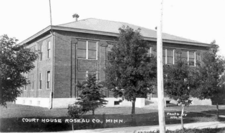
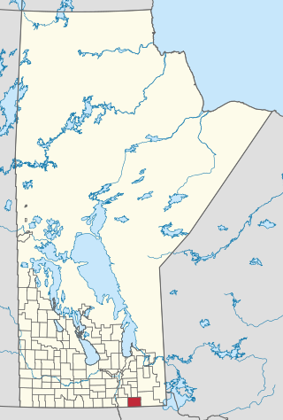
Roseau County is a county in the northwestern part of the U.S. state of Minnesota, along the Canada–US border. As of the 2020 census, the population was 15,331. Its county seat is Roseau. Roseau County borders the Canadian province of Manitoba.

<span class="mw-page-title-main">Lake of the Woods County, Minnesota</span> County in Minnesota, United States

Lake of the Woods County is a county in the northwestern part of the U.S. state of Minnesota. As of the 2020 census, the population was 3,763, making it the second-least populous county in Minnesota. Its county seat is Baudette.

<span class="mw-page-title-main">Dieter Township, Roseau County, Minnesota</span> Township in Minnesota, United States

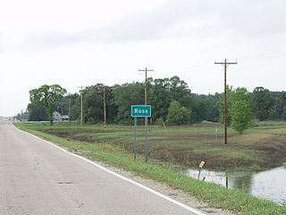
Dieter Township is a township in Roseau County, Minnesota, United States located along the Canada–US border. The population was 162 at the 2000 census. Dieter Township contains the unincorporated communities of Pinecreek and Ross.

<span class="mw-page-title-main">Warroad, Minnesota</span> City in Minnesota, United States

Warroad is a city in Roseau County, Minnesota, United States, at the southwest corner of Lake of the Woods, 7.5 miles (12.1 km) south of Canada. The population was 1,781 at the 2010 census. Warroad had its own newspaper before it was incorporated in 1901.

<span class="mw-page-title-main">Northwest Angle</span> Part of Minnesota, separated from the rest of the state by the Lake of the Woods

The Northwest Angle, known simply as the Angle by locals, and coextensive with Angle Township, is a pene-exclave of northern Lake of the Woods County, Minnesota. Except for surveying errors, it is the only place in the contiguous United States north of the 49th parallel, which forms the border between the U.S. and Canada from the Northwest Angle westward to the Strait of Georgia. The land area of the Angle is separated from the rest of Minnesota by Lake of the Woods, but shares a land border with Canada. It is one of six non-island locations in the 48 contiguous states that are practical exclaves of the U.S. It is the northernmost township in Minnesota and contains the northernmost point in the contiguous 48 states. The unincorporated community of Angle Inlet is in the Northwest Angle.

<span class="mw-page-title-main">Piney Pinecreek Border Airport</span> Airport in Canada–United States border

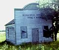
Piney Pinecreek Border Airport is a public use general aviation airport located 2 nautical miles northwest of the central business district of Pinecreek, in Dieter Township, Roseau County, Minnesota, United States, on the Canada–US border. It is jointly owned by the Minnesota Department of Transportation and the government of Piney, Manitoba. It is shared by the rural communities of Piney, Manitoba and Pinecreek, Minnesota.

Provincial Trunk Highway 89 is a provincial highway in the Canadian province of Manitoba. The entire road lies within the Rural Municipality of Piney and is 10 kilometres long. It runs from PTH 12 south to Piney and the U.S. border. South of the border it becomes Minnesota State Highway 89.

<span class="mw-page-title-main">Eastman Region</span> Region in Manitoba, Canada

Eastern Manitoba, or the Eastman Region, is an informal geographic region of the Canadian province of Manitoba. It is bounded on the north by the Winnipeg River and Lake Winnipeg, on the east by the Manitoba-Ontario border, on the south by the Canada–US border, and on the west by the Red River. With a population of 128,855 as of the 2021 Canadian census, the Eastman Region is the second most populous region outside of the Winnipeg Metropolitan Region.

<span class="mw-page-title-main">Rural Municipality of Taché</span> Rural municipality in Manitoba, Canada

Taché is a rural municipality in Manitoba, Canada, incorporated in 1880.

<span class="mw-page-title-main">Rural Municipality of Reynolds</span> Rural municipality in Manitoba, Canada

The Rural Municipality of Reynolds is a rural municipality (RM) in southeastern Manitoba, Canada.

<span class="mw-page-title-main">Sandilands Provincial Forest</span> Protected forest in Manitoba, Canada

The Sandilands Provincial Forest is a forest located within the southeastern area of Manitoba, Canada, and consists of thousands of acres of sand hills, forest, wetlands, and mostly unpopulated crown lands. Sandilands Provincial Forest covers close to 3,000 km2.

<span class="mw-page-title-main">Manitoba Highway 12</span> Highway in Manitoba

Provincial Trunk Highway 12 is a provincial primary highway located in the Canadian province of Manitoba. Lying entirely in the Eastman Region, it runs from the U.S. border to a dead end in Grand Beach. PTH 12 forms the Manitoba section of MOM's Way, a tourist route from Thunder Bay to Winnipeg. PTH 12 is primarily a two-lane highway except for two four-lane stretch between Steinbach and PTH 1 and a ten-kilometre concurrency with PTH 44.

Piney is a community in southeastern Manitoba, Canada, in the Rural Municipality of Piney. It is approximately 130 kilometers from Winnipeg and within five kilometres of the Canada–US border.

Sprague is a community within the Rural Municipality of Piney in the Canadian province of Manitoba. It is named after D.E. Sprague, a prominent Winnipeg lumber merchant. The community is located in the extreme southeast corner of the province near the Canada–United States border, at the junction of Manitoba Highway 12 and Provincial Road 308.

<span class="mw-page-title-main">Rural Municipality of Stuartburn</span> Rural municipality in Manitoba, Canada

Stuartburn is a rural municipality (RM) located in the Eastman Region of Manitoba, Canada. It had a population of 1,629 according to the Canada 2006 Census.

The Rural Municipality of Franklin is a former rural municipality (RM) in the Canadian province of Manitoba. It was incorporated on December 22, 1883. It ceased on January 1, 2015 as a result of a provincially mandated amalgamation with the Town of Emerson to form the Municipality of Emerson – Franklin.

<span class="mw-page-title-main">Municipality of Emerson-Franklin</span> Rural municipality in Manitoba, Canada

The Municipality of Emerson – Franklin is a rural municipality (RM) in the Canadian province of Manitoba.

<span class="mw-page-title-main">Roseau–South Junction Border Crossing</span>

The Roseau–South Junction Border Crossing connects the cities of Roseau, Minnesota and South Junction, Manitoba on the Canada–United States border. It is connected by Minnesota State Highway 310 in Roseau County on the American side and Manitoba Provincial Road 310 in the Rural Municipality of Piney on the Canadian side. The crossing was established in 1948, and Canada is still using the border station it completed in 1953, which is located about a half mile north of the border. The US rebuilt its border station in 2004.

<span class="mw-page-title-main">Warroad–Sprague Border Crossing</span> Port of entry on the Canada-United States border

The Warroad–Sprague Border Crossing connects the city of Warroad, Minnesota and community of Sprague, Manitoba on the Canada–United States border. Minnesota State Highway 313 on the American side joins Manitoba Highway 12 on the Canadian side. The crossing is:

<span class="mw-page-title-main">Manitoba Provincial Road 203</span>

Provincial Road 203 is a provincial road in the southeastern part of the Canadian province of Manitoba.

References

  1. 1 2 "Population and dwelling counts: Canada, provinces and territories, and census subdivisions (municipalities), Manitoba". Statistics Canada. February 9, 2022. Retrieved February 20, 2022.
  2. "Piney, Manitoba". Canadian Climate Normals 1971–2000 (in English and French). Environment Canada. Retrieved February 5, 2014.