Rural Municipality of Rosedale | |
---|---|
Coordinates: 50°26′23″N99°32′20″W / 50.43972°N 99.53889°W | |
Country | Canada |
Province | Manitoba |
Region | Westman |
Area | |
• Land | 864.55 km2 (333.80 sq mi) |
Population | |
• Total | 1,524 |
Time zone | UTC-6 (CST) |
• Summer (DST) | UTC-5 (CDT) |
Area codes | 204 and 431 |
Rosedale is a rural municipality (RM) in the province of Manitoba in Western Canada. The southeast corner of Riding Mountain National Park overlaps the northwest corner of the RM, and comprises about one-sixth of Rosedale's territory.[ citation needed ] The Town of Neepawa borders the municipality.
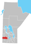
In the 2021 Census of Population conducted by Statistics Canada, Rosedale had a population of 1,524 living in 507 of its 587 total private dwellings, a change of -8.9% from its 2016 population of 1,672. With a land area of 864.68 km2 (333.85 sq mi), it had a population density of 1.8/km2 (4.6/sq mi) in 2021. [1]
Mountain Road Hall hosts a spring and fall craft sale [2]
Rosser is a rural municipality (RM) in the Canadian province of Manitoba, lying adjacent to the northwest side of Winnipeg and part of the Winnipeg Metro Region. Its population as of the 2016 Census was 1,372.
The Rural Municipality of Lakeview was a rural municipality (RM) in the Canadian province of Manitoba.
McCreary is an unincorporated urban community in the Municipality of McCreary, Manitoba, Canada.
Dauphin is a rural municipality in the Parkland Region of Manitoba, Canada. The municipality surrounds the separately administered city of Dauphin, and lies just north of Riding Mountain National Park, part of which extends into the RM.
East Selkirk is a community of 675 in the Rural Municipality (RM) of St. Clements in the Canadian province of Manitoba. It is directly across the Red River from Selkirk, Manitoba.
Springfield is a rural municipality (RM) in Manitoba, Canada. It stretches from urban industrial development on the eastern boundary of the city of Winnipeg, through urban, rural residential, agricultural and natural landscapes, to the Agassiz Provincial Forest on the municipality's eastern boundary. Birds Hill Provincial Park nestles into the north-western corner of Springfield.
Vita is a local urban district in southeast Manitoba settled by Ukrainian immigrants in the late 1890s. It is roughly 50 km (31 mi) by road from Steinbach in the Rural Municipality of Stuartburn.
The Rural Municipality of Montcalm is a rural municipality (RM) in the Pembina Valley Region of Manitoba in Western Canada.
Stuartburn is a rural municipality (RM) located in the Eastman Region of Manitoba, Canada. It had a population of 1,629 according to the Canada 2006 Census.
The Rural Municipality of Grant No. 372 is a rural municipality (RM) in the Canadian province of Saskatchewan within Census Division No. 15 and SARM Division No. 5. The RM's office is located in Vonda.
The Rural Municipality of Laurier No. 38 is a rural municipality (RM) in the Canadian province of Saskatchewan within Census Division No. 2 and SARM Division No. 2. it is located in the southeast portion of the province.
The Rural Municipality of Sliding Hills No. 273 is a rural municipality (RM) in the Canadian province of Saskatchewan within Census Division No. 9 and SARM Division No. 4.
Philip Ruh, O.M.I. was Catholic priest and church architect. Although he was educated as a Belgian Oblate, he is remembered for his work in Canada with the Eastern Catholic Ukrainian Canadian community building over forty Byzantine Rite churches and several grottos in a unique architectural style that mixed Byzantine, Latin, and modern Canadian influences. The style is often called prairie cathedral, which is a common nickname for several of his churches, even though only two of them are properly cathedrals.
Howden is a hamlet in the province of Manitoba, Canada. It is located 17 kilometres south of downtown Winnipeg within the Rural Municipality of Ritchot.
The Municipality of Emerson – Franklin is a rural municipality (RM) in the Canadian province of Manitoba.
Grandview Municipality is a rural municipality (RM) in the Parkland Region of Manitoba, Canada. It is located in a valley between Duck Mountain Provincial Forest & Park and Riding Mountain National Park, which both lie partially within the RM's territory.
The Municipality of Harrison Park is a rural municipality (RM) in the Canadian province of Manitoba that incorporated on January 1, 2015 via the amalgamation of the RMs of Harrison and Park. It was formed as a requirement of The Municipal Amalgamations Act, which required that municipalities with a population less than 1,000 amalgamate with one or more neighbouring municipalities by 2015. The Government of Manitoba initiated these amalgamations in order for municipalities to meet the 1997 minimum population requirement of 1,000 to incorporate a municipality.
The Municipality of McCreary is a rural municipality (RM) in the Parkland Region of Manitoba, Canada.
Polonia is an unincorporated community in the Rural Municipality of Rosedale in Manitoba, Canada. It is located 82 kilometres north-east of Brandon, Manitoba.
Provincial Road 265 is a 80.6-kilometre-long (50.1 mi) east–west road in the Westman and Central Plains Regions of Manitoba. Mostly a gravel road, it connects the communities of Clanwilliam, Polonia, Eden, Plumas, and Langruth, as well as providing a connection between Riding Mountain National Park and Lake Manitoba.