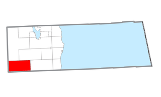
Curtis Township is a civil township of Alcona County in the U.S. state of Michigan. The population was 1,236 at the 2010 census.

Roblin is an unincorporated urban community in the Municipality of Hillsburg – Roblin – Shell River within the Canadian province of Manitoba that held town status prior to January 1, 2015. It is located approximately 400 km northwest of Winnipeg, Manitoba's capital.
For the municipality, see the Rural Municipality of Clanwilliam
Headsville is an unincorporated community in Mineral County, West Virginia, United States. It is part of the Cumberland, MD-WV Metropolitan Statistical Area. It lies between U.S. Route 50 and West Virginia Route 46 alongside Pattersons Creek.
Fort Alexander is a community in Manitoba, Canada, located on the Sagkeeng First Nation, on the south bank of the Winnipeg River. The Sagkeeng area at the mouth of the Winnipeg River, was originally settled with native camps used for fishing, hunting, and trade.
Erickson is an unincorporated urban community in the Municipality of Clanwilliam – Erickson within the Canadian province of Manitoba that held town status prior to 1 January 2015. It is located on Highway 10 on 32-17-18W in south central Manitoba. The main industry of Erickson is agriculture. Its population is 487.

Fort Dauphin, was built in 1741 near Winnipegosis, Manitoba with Pierre Gaultier de La Vérendrye, the western military commander, directing construction. The area provided a post located between the Assiniboine River and the Saskatchewan River. It was named for the Dauphin prince of France.
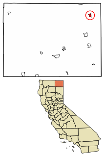
Fort Bidwell is a census-designated place in Modoc County, California. It is located 32 miles (51 km) northeast of Alturas, at an elevation of 4564 feet. The population was 173 at the 2010 census.
Onanole is a unincorporated hamlet within the Municipality of Harrison Park in Manitoba, Canada.

Centerville is an unincorporated community in Butte County, California along Butte Creek. It was midway between Helltown and Diamondville. The area is about one and three quarters miles, straight-line distance, west of Paradise.
White Hall is a small unincorporated community in El Dorado County, California, United States. It is located on the South Fork of the American River 2.5 miles (4.0 km) east of Riverton, at an elevation of 3383 feet. The ZIP code is 95726. The community is inside area code 530.
Monte Creek is a rural locality on the South Thompson River east of Kamloops, British Columbia, Canada, approximately equidistant from Kamloops and the village of Chase, British Columbia. It is mostly notable as a major highway junction where British Columbia Highway 97 branches off from the Trans-Canada Highway south towards the Okanagan via Falkland and Westwold. Monte Lake, a recreational community on the shores of the lake of the same name, is a few miles south of the junction.
Armstrong is a rural municipality in the province of Manitoba in Western Canada. It lies in the southern area of the Interlake and was named after James William Armstrong, a Manitoba politician.
The Rural Municipality of Minto is a former rural municipality (RM) in the Canadian province of Manitoba. It was originally incorporated as a rural municipality on November 15, 1902. It ceased on January 1, 2015 as a result of its provincially mandated amalgamation with the RM of Odanah to form the Rural Municipality of Minto – Odanah.
Strathclair is a locality in the province of Manitoba in Western Canada. It is located northwest of Brandon, Manitoba and is on Highway 16. It lies within the Rural Municipality of Yellowhead.
Bliss Landing, formerly Bishop Landing or Bishops Landing, was a cannery town on the South Coast of British Columbia, Canada, located on the northwest side of the Malaspina Peninsula on the upper Sunshine Coast, north of the town of Lund and across the mouth of Desolation Sound from Cortes Bay and Manson's Landing on Cortes Island.
For the municipality, see: the Rural Municipality of Alexander

Arizona is a locality in the Rural Municipality of North Norfolk in south central Manitoba, Canada. It is located approximately 66 kilometers east of Brandon, Manitoba, about 377m above sea level in an area which experiences frequent drought.


