Related Research Articles
For the municipality, see the Rural Municipality of Clanwilliam
The Rural Municipality of Lakeview is a former rural municipality (RM) in the Canadian province of Manitoba. It was originally incorporated as a rural municipality on April 10, 1920. It ceased on January 1, 2015 as a result of its provincially mandated amalgamation with the RM of Westbourne and the Town of Gladstone to form the Municipality of WestLake – Gladstone.
Erickson is an unincorporated urban community in the Municipality of Clanwilliam – Erickson within the Canadian province of Manitoba that held town status prior to 1 January 2015. It is located on Highway 10 on 32-17-18W in south central Manitoba. The main industry of Erickson is agriculture. Its population is 487.
St. Clements is a rural municipality in Manitoba, Canada. It is located to the north-east of Winnipeg, stretching from East St. Paul and Birds Hill Provincial Park in the south to Lake Winnipeg and Grand Beach Provincial Park to the north. The Red River demarcates the western boundary of the municipality. St. Clements contains the communities of East Selkirk, and Lockport east of the Red River. It almost completely surrounds the Brokenhead 4 Indian reserve, with the exception of a small lakefront on Lake Winnipeg. Its population at the 2001 census was 9,115. The city of Selkirk borders it to the west, across the Red River of the North.
A block settlement is a particular type of land distribution which allows settlers with the same ethnicity to form small colonies.
The Rural Municipality of Glenwood is a former rural municipality (RM) in the Canadian province of Manitoba. It was originally incorporated as a rural municipality on December 22, 1883. It ceased on January 1, 2015 as a result of its provincially mandated amalgamation with the Town of Souris to form the Municipality of Souris – Glenwood.

Zhoda is a community in southeastern Manitoba, Canada, approximately 20 km north of the town of Vita. Although "Zhoda Corner" is situated at the intersection of PTH 12 and Manitoba Provincial Road 302, in the Rural Municipality of La Broquerie, the "heart" of Zhoda is the area located near the Zhoda Community Hall and the Ukrainian Catholic Church in the centre of the community, which is also part of the Rural Municipality of Stuartburn.

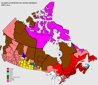
Census Division No. 15 Western Manitoba is part of the Westman Region of the province of Manitoba, Canada. The economy of the region is based on agriculture, livestock and hog processing. The population of the area based on the 2006 census was 21,417. Also included in the division are the main reserves of the Birdtail Sioux First Nation, the Keeseekoowenin Ojibway First Nation, and the Rolling River First Nation.
Armstrong is a rural municipality in the province of Manitoba in Western Canada. It lies in the southern area of the Interlake and was named after James William Armstrong, a Manitoba politician.
The Rural Municipality of Minto is a former rural municipality (RM) in the Canadian province of Manitoba. It was originally incorporated as a rural municipality on November 15, 1902. It ceased on January 1, 2015 as a result of its provincially mandated amalgamation with the RM of Odanah to form the Rural Municipality of Minto – Odanah.

Ninette is an unincorporated community recognized as a local urban district located in Manitoba, Canada at the north end of Pelican Lake. It is located in the Rural Municipality of Prairie Lakes. Ninette has many small businesses, and is known locally for its wide range of sports facilities. In the summer, activities such as boating, fishing, and hunting are offered, while snowmobiling and ice fishing are offered during the wintertime.
The Rural Municipality of Ste. Rose is a former rural municipality (RM) in the Canadian province of Manitoba. It was originally incorporated as a rural municipality on November 15, 1902. It ceased on January 1, 2015 as a result of its provincially mandated amalgamation with the Town of Ste. Rose du Lac to form the Municipality of Ste. Rose.
Grant No. 372 is a rural municipality in north-central Saskatchewan, Canada encompassing 802.93 square kilometers in area. The rural municipality maintains its office in Vonda, Saskatchewan. The rural municipality in conjunction with the provincial government is in charge of maintenance of highways in its area. As well, the municipality provides policing, fire protection and municipal governance for the rural district, with a reeve as its administrator.

Kingsley No. 124 is a rural municipality in south-eastern Saskatchewan, Canada encompassing 844.61 square kilometers in area. The rural municipality maintains its office in Kipling, Saskatchewan. The rural municipality, in conjunction with the provincial government, is in charge of the maintenance of highways in its area. As well as this, the municipality provides policing, fire protection and municipal governance for the rural district, with a reeve as its administrator.
Fertile Belt No. 183 is a rural municipality in Saskatchewan, Canada encompassing 1,006.68 square kilometers in area. The rural municipality maintains its office in Stockholm, Saskatchewan. The rural municipality in conjunction with the provincial government is in charge of maintenance of highways in its area. As well, the municipality provides policing, fire protection and municipal governance for the rural district, with a reeve as its administrator.
Newcombe No. 260 is a rural municipality in west-central Saskatchewan, Canada encompassing 1,075.60 square kilometers in area. The rural municipality is at the intersection of Highway 21 and Highway 44. The Lemsford Ferry is located within the rural municipality. The rural municipality maintains its office in Glidden, Saskatchewan. The rural municipality in conjunction with the provincial government is in charge of maintenance of highways in its area. The rural municipality was established in 1911 and is named after Allan Simpson Newcombe who played a leadership role in establishing the Boston Colony of immigrants from Massachusetts. Glidden is named after Charles Glidden who sold the town site to the Canadian Pacific Railway.
The Rolling River First Nation has a total registered population of just under 1000 band members. About half of the members are resident on the First Nation reserves which are located south and east of Erickson, Manitoba. Band #291 are in possession of three reserves. The main reserve is bordered mostly by the Rural Municipality of Harrison, but also has a significant border with the Rural Municipality of Clanwilliam, plus a much smaller border with the Rural Municipality of Minto.
Manitoba Provincial Road 262 is a provincial road in the southwestern section of the Canadian province of Manitoba.
References
- Geographic Names of Manitoba (pg. 112) – the Millennium Bureau of Canada
- Hilltop Baptist Church
- Manitoba Historical Society – Oral History: Clanwilliam, 1918
- Historic Sites of Manitoba: Hilltop Baptist Church and Cemetery
Division No. 15, Manitoba (Western Manitoba) | ||||
|---|---|---|---|---|
| Towns |
|  | ||
| Villages |
| |||
| Rural municipalities |
| |||
| First Nations | ||||
| Indian reserves | ||||
| Unincorporated communities |
| |||
Coordinates: 50°28′11″N99°48′48″W / 50.46972°N 99.81333°W

A geographic coordinate system is a coordinate system that enables every location on Earth to be specified by a set of numbers, letters or symbols. The coordinates are often chosen such that one of the numbers represents a vertical position and two or three of the numbers represent a horizontal position; alternatively, a geographic position may be expressed in a combined three-dimensional Cartesian vector. A common choice of coordinates is latitude, longitude and elevation. To specify a location on a plane requires a map projection.
| This Manitoba location article is a stub. You can help Wikipedia by expanding it. |