
Seligman is a census-designated place (CDP) on the northern border of Yavapai County, in northwestern Arizona, United States. The population was 456 at the 2000 census.

Walden was a town in the Canadian province of Ontario, which existed from 1973 to 2000. Created as part of the Regional Municipality of Sudbury when regional government was introduced, the town was dissolved when the city of Greater Sudbury was incorporated on January 1, 2001. The name Walden continues to be informally used to designate the area.

Barrhead is a town in central Alberta, Canada that is surrounded by the County of Barrhead No. 11. It is located along the Paddle River and at the intersection of Highway 33 and Highway 18, approximately 120 km (75 mi) northwest of the City of Edmonton. It is also located along the route of the Express Trail, used by the North West Company. Originally an Indian that was widened by George Simpson and John Rowand to save the North West Company over $5,000.

Gillam is a town on the Nelson River in northern Manitoba, Canada. It is situated between Thompson and Churchill on the Hudson Bay Railway line.
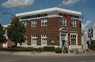
Transcona is a ward and suburb of Winnipeg, Manitoba, located about 10 kilometres (6.2 mi) east of the downtown area.
Emerson is an unincorporated community recognized as a local urban district in south central Manitoba, Canada, located within the Municipality of Emerson – Franklin. It has a population of 678 as of the 2016 Canada census.
Qu'Appelle is a town in Saskatchewan, located on Highway 35 approximately 50 km (31 mi) east of the provincial capital of Regina.

Carberry is a town in southwestern Manitoba, Canada. It is situated 3 kilometres south of the Trans-Canada Highway on Highway 5 in the Municipality of North Cypress – Langford, and has a population of 1,738 people.

Neepawa is a town in Manitoba, Canada located on the Yellowhead Highway at the intersection with Highway 5. As of 2021 its population was 5,685. Neepawa was incorporated as a town in 1883. It is bordered by the Municipality of North Cypress – Langford and Rural Municipality of Rosedale. Neepawa is the self-proclaimed Lily capital of the world in part because of its Lily Festival.
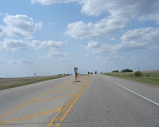
Highway 1 is the Saskatchewan section of the Trans-Canada Highway mainland route. The total distance of the Trans-Canada Highway in Saskatchewan is 654 kilometres (406 mi). The highway traverses Saskatchewan from the western border with Alberta, from Highway 1, to the Manitoba border where it continues as PTH 1. The Trans-Canada Highway Act was passed on December 10, 1949. The Saskatchewan segment was completed August 21, 1957, and completely twinned on November 6, 2008. The speed limit along the majority of the route is 110 kilometres per hour (70 mph) with urban area thoroughfares slowing to a speed of 80–100 kilometres per hour (50–62 mph). Portions of the highway—the section through Swift Current, an 8-kilometre (5 mi) section east of Moose Jaw, and a 44-kilometre (27 mi) section between the West Regina Bypass and Balgonie—are controlled-access. Highway 1 serves as a major east-west transport route for commercial traffic. It is the main link between southern Saskatchewan's largest cities, and also serves as the province's main link to the neighbouring provinces of Alberta and Manitoba.
Highway 16 is a provincial highway in the Canadian province of Saskatchewan. It is the Saskatchewan section of the Yellowhead Highway, and also the Trans-Canada Highway Yellowhead section. The main purpose of this highway is to connect Saskatchewan with Canadian cities such as Edmonton and Winnipeg. The highway runs from the Alberta boundary in Lloydminster to the Manitoba boundary near Marchwell. Major cities it passes through are Saskatoon, North Battleford in the central part of the province, Yorkton in the far east and Lloydminster to the far west.

Willow Bunch is a town in Saskatchewan, Canada. It is located 190 kilometres (120 mi) southwest of the provincial capital of Regina. The population was 286 at the 2011 census.

Argyle is a small hamlet located in the Canadian province of Manitoba. Argyle is in Manitoba's Interlake Region. It is part of the Rural Municipality of Rockwood. It is approximately 30 km from Manitoba's capital, Winnipeg. Nearby are the towns of Stonewall, Balmoral, Teulon, Grosse Isle, Gunton, Rosser, Stony Mountain and Selkirk. The major industry is agriculture, where mixed farming prevails. Many residents work in Winnipeg or surrounding towns.

Elma, Manitoba, is an unincorporated community of approximately 100 people in southeast Manitoba. It is located on the Whitemouth River, at the junction of Highway 15 and Highway 11 in the Rural Municipality of Whitemouth.

Ogema is a town with a population of 403 located in south Central Saskatchewan, Canada. It is approximately 115 kilometres (71 mi) south of Saskatchewan's capital city, Regina, and about midway between Weyburn and Assiniboia on Saskatchewan Highway 13.

Carlyle is a town in the province of Saskatchewan, Canada. Carlyle is the largest town servicing the far south-eastern corner of Saskatchewan and as a result, has become the economic and services centre of the region. Estevan and Weyburn are the closest cities and both are a little over 100 kilometres away. Regina, the provincial capital, lies 200 km to the north-west.

The Ward was a neighbourhood in central Toronto, Ontario, Canada, in the 19th and early 20th centuries. Many new immigrants first settled in the neighbourhood; it was at the time widely considered a slum.

William Kennedy was a Canadian fur trader, politician, and historian.

Bromhead is an unincorporated community and ghost town in Souris Valley Rural Municipality No. 7, Saskatchewan, Canada. The community is approximately 5 km (3.1 mi) north of Highway 18 and 45 km (28 mi) west of the City of Estevan.
Plumas is an unincorporated community recognized as a local urban district located in the Municipality of WestLake – Gladstone, in the Canadian province of Manitoba. Plumas is roughly 70 km northwest of Portage la Prairie, Manitoba, and about 150 km northwest of the provincial capital, Winnipeg.

