Northern Canada, colloquially the North or the Territories, is the vast northernmost region of Canada, variously defined by geography and politics. Politically, the term refers to the three territories of Canada: Yukon, Northwest Territories and Nunavut. This area covers about 48 per cent of Canada's total land area, but has less than 0.5 per cent of Canada's population.

The Rural Municipality of Gimli is a rural municipality located in the Interlake Region of south-central Manitoba, Canada, on the western shore of Lake Winnipeg. It is about 75 kilometres (47 mi) north of the provincial capital Winnipeg. The rural municipality's population in the 2016 Canadian Census was 6,181, making it the 12th largest rural municipality by population. The RM of Gimli has an area of 318.75 km2 (123.07 sq mi), making it the sixth smallest rural municipality by area.
Roblin is an unincorporated urban community in the Municipality of Roblin, Manitoba, Canada. It is located approximately 400 km (250 mi) northwest of Winnipeg.

The Westman Region is an informal geographic region of the Canadian province of Manitoba located in the southwestern corner of the province.

Hamiota is an unincorporated urban community in the Hamiota Municipality within the Canadian province of Manitoba that held town status prior to January 1, 2015. It is located on Provincial Trunk Highway 21 midway between the Trans-Canada Highway and the Yellowhead Highway. It is located in Western Manitoba, 84 kilometers northwest of Brandon. The trading area radius of 20 kilometres has approximately 10,000 people. First known as Hamilton, for Thomas Hamilton, one of the first settlers, the town name was changed to avoid confusion with Hamilton, Ontario. The new name contracted Hamilton with the Sioux word ota, "much".
First Nations in Manitoba constitute of over 160,000 registered persons as of 2021, about 57% of whom live on reserve. Manitoba is second to Ontario in total on-reserve population and in total First Nation population.

The Rural Municipality of Hanover is a rural municipality (RM) in southeastern Manitoba, Canada, located southeast of Winnipeg in Division No. 2.

Minnedosa is a town in the southwestern part of the Canadian province of Manitoba situated 50 kilometres (32 mi) north of Brandon, Manitoba on the Little Saskatchewan River. The town's name means "flowing water" in the Dakota language. The population of Minnedosa reported in the 2021 Canadian Census was 2,741. The town is surrounded by the Rural Municipality of Minto – Odanah.

Morris is a small town in the Pembina Valley region of Manitoba, Canada, located 51 km south of Winnipeg and 42 km north of Emerson. Morris is home to 1,885 people (2016). Named after Alexander Morris, the second Lieutenant Governor of Manitoba.

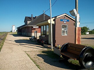
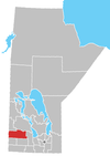
Rivers is an unincorporated urban community in the Riverdale Municipality within the Canadian province of Manitoba. It is located 40 kilometres (25 mi) northwest of Brandon, 473 metres (1,552 ft) above sea level. It is within the Westman Region. Agriculture, health and related businesses provide income for the community and area. Rivers has a population of 1,257 people in the 2016 census.

Benito is an unincorporated urban community in the Municipality of Swan Valley West, Manitoba, Canada.

Moose Lake is a small community in Manitoba, Canada. It is located on the eastern edge of the Saskatchewan River Delta on the western shore of South Moose Lake about 74 km southeast of The Pas. Adjacent to the non-treaty community is a First Nations reserve, home to the Mosakahiken Cree Nation.

Strongfield is a village in the Canadian province of Saskatchewan within the Rural Municipality of Loreburn No. 254 and Census Division No. 11. It lies approximately 100 km south of the city of Saskatoon on Highway 19 between its sister communities of Hawarden and Loreburn.

Census Division No. 8 is a census division located within the Central Plains Region of the Province of Manitoba, Canada. Unlike in some other provinces, census divisions do not reflect the organization of local government in Manitoba. These areas exist solely for the purposes of statistical analysis and presentation; they have no government of their own.

Census Division No. 15 is a census division located within the Westman Region of the province of Manitoba, Canada. Unlike in some other provinces, census divisions do not reflect the organization of local government in Manitoba. These areas exist solely for the purposes of statistical analysis and presentation; they have no government of their own.

The Rural Municipality of Victory No. 226 is a rural municipality (RM) in the Canadian province of Saskatchewan within Census Division No. 7 and SARM Division No. 3.

Blumenort is a local urban district in the Canadian province of Manitoba. It is located in the Rural Municipality of Hanover, 4.1 kilometres north of the city of Steinbach. It was founded in 1874 by Plautdietsch-speaking Mennonite farmers from the Russian Empire. Today, its economy is based on agriculture and the service industry.
The Mathias Colomb Cree Nation (MCCN) —also known as Mathias Colomb First Nation, Mathias Colomb (Cree) First Nation, and Pukatawagan/Mathias Colomb Cree Nation—is a remote First Nations community in northern Manitoba, located 210 km (130 mi) north of The Pas and 819 km (509 mi) northwest of Winnipeg, Manitoba.

The Municipality of Souris-Glenwood is a rural municipality (RM) in the Canadian province of Manitoba.
Oak Bluff is an incorporated community located in the Rural Municipality of Macdonald, Manitoba, Canada. It is situated seven kilometres southwest of the City of Winnipeg, between Manitoba Highway (PTH) 3's intersections with PTH 2 and PTH 100. The community has a population of 1,442 as of the 2021 Canadian census


