Birtle is an unincorporated urban community in the Prairie View Municipality within the Canadian province of Manitoba that held town status prior to January 1, 2015. It is located at the junction of Highways 83 and 42.

The Westman Region is an informal geographic region of the Canadian province of Manitoba located in the southwestern corner of the province.

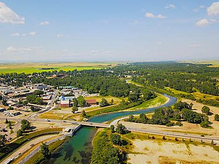
Hamiota is an unincorporated urban community in the Hamiota Municipality within the Canadian province of Manitoba that held town status prior to January 1, 2015. It is located on Provincial Trunk Highway 21 midway between the Trans-Canada Highway and the Yellowhead Highway. It is located in Western Manitoba, 84 kilometers northwest of Brandon. The trading area radius of 20 kilometres has approximately 10,000 people. First known as Hamilton, for Thomas Hamilton, one of the first settlers, the town name was changed to avoid confusion with Hamilton, Ontario. The new name contracted Hamilton with the Sioux word ota, "much".
High River is a town within the Calgary Metropolitan Region of Alberta, Canada. It is approximately 68 kilometres (42 mi) south of Calgary, at the junction of Alberta Highways 2 and 23. High River had a population of 14,324 in 2021.
Erickson is an unincorporated urban community in the Municipality of Clanwilliam – Erickson within the Canadian province of Manitoba that held town status prior to 1 January 2015. It is located on Highway 10 on 32-17-18W in south central Manitoba. The main industry of Erickson is agriculture.
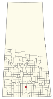
Waldeck is a village in the Canadian province of Saskatchewan within the Rural Municipality of Excelsior No. 166 and Census Division No. 7. Waldeck is 18 kilometres northeast of the City of Swift Current on the Trans-Canada Highway. Waldeck is situated in the Swift Current River Valley.
The Rural Municipality of Antler No. 61 is a rural municipality (RM) in the Canadian province of Saskatchewan within Census Division No. 1 and SARM Division No. 1.

The Rural Municipality of Hudson Bay No. 394 is a rural municipality (RM) in the Canadian province of Saskatchewan within Census Division No. 14 and SARM Division No. 4. At 12,462 square kilometres in area, it is the largest rural municipality in Saskatchewan. It is located in the northeast-central portion of the province.

Division No. 19, also informally known as North East Manitoba, is a census division within the Province of Manitoba, Canada. Unlike in some other provinces, census divisions do not reflect the organization of local government in Manitoba. These areas exist solely for the purposes of statistical analysis and presentation; they have no government of their own.
Pierceland is a village in the Canadian province of Saskatchewan within the Rural Municipality of Beaver River No. 622 and Census Division No. 17. It is north of the Beaver River on Saskatchewan Highway 55.
Division No. 6 (Virden) is a census division located within the Westman Region of south west Manitoba, located in the unceded territory of the Dakota people in Treaty 2. Unlike in some other provinces, census divisions do not reflect the organization of local government in Manitoba. These areas exist solely for the purposes of statistical analysis and presentation; they have no government of their own.
Census Division No. 8 is a census division located within the Central Plains Region of the Province of Manitoba, Canada. Unlike in some other provinces, census divisions do not reflect the organization of local government in Manitoba. These areas exist solely for the purposes of statistical analysis and presentation; they have no government of their own.
Census Division No. 9 is a census division located within the Central Plains Region of the Province of Manitoba, Canada. Unlike in some other provinces, census divisions do not reflect the organization of local government in Manitoba. These areas exist solely for the purposes of statistical analysis and presentation; they have no government of their own.
Census Division No. 20 is a census division located within the Parkland Region of the province of Manitoba. Unlike in some other provinces, census divisions do not reflect the organization of local government in Manitoba. These areas exist solely for the purposes of statistical analysis and presentation; they have no government of their own.
Census Division No. 18 is a census division located within the Interlake Region of the province of Manitoba, Canada. Unlike in some other provinces, census divisions do not reflect the organization of local government in Manitoba. These areas exist solely for the purposes of statistical analysis and presentation; they have no government of their own.
Census Division No. 17 (Dauphin) is a census division located within the Parklands Region of the province of Manitoba, Canada. Unlike in some other provinces, census divisions do not reflect the organization of local government in Manitoba. These areas exist solely for the purposes of statistical analysis and presentation; they have no government of their own.
Census Division No. 16 is a census division located within the Parklands Region of the province of Manitoba, Canada. Unlike in some other provinces, census divisions do not reflect the organization of local government in Manitoba. These areas exist solely for the purposes of statistical analysis and presentation; they have no government of their own.
The Rural Municipality of Hillsborough No. 132 is a rural municipality (RM) in the Canadian province of Saskatchewan within Census Division No. 7 and SARM Division No. 2. At 445.25 square kilometres in area, it is the smallest rural municipality in Saskatchewan.
The Prairie Mountain Health is the governing body responsible for healthcare delivery and regulation for the eponymous health region in southwest Manitoba.
Hamiota Municipality is an incorporated municipality in the Canadian province of Manitoba.


