
Seven Persons is a hamlet in Alberta, Canada within Cypress County. It is located approximately 20 kilometres (12 mi) southwest of Medicine Hat on Highway 3 and has an elevation of 755 metres (2,477 ft).

The Rural Municipality of Alexander is a rural municipality in the Eastman Region of Manitoba, Canada. The town of Powerview-Pine Falls lies adjacent to the municipality, as does the Sagkeeng First Nation Indian reserve.

Gretna is an unincorporated urban community in the Municipality of Rhineland within the Canadian province of Manitoba that held town status prior to January 1, 2015. Just north of the Canada - United States border on PTH 30, Gretna had a population of 541 in 2016.

Winnipeg Beach is a town in the Interlake Region, in the Canadian province of Manitoba. The town was founded in 1900 by Sir William Whyte and is located at the junction of Highway 9 and Highway 229 on the southwestern shore of Lake Winnipeg, about 56 kilometres (35 mi) north of Winnipeg. It is bordered by the Rural Municipality of Gimli, the Rural Municipality of St. Andrews, and Dunnottar as well as Lake Winnipeg. Nearby towns are Ponemah, Whytewold, and Matlock, Gimli, and Sandy Hook,, as well as Teulon, and Selkirk. Its permanent population is 1,145.
Rosenort, Manitoba, is an unincorporated community recognized as a local urban district within the Rural Municipality of Morris about 17 kilometres from the town of Morris and about 47 kilometres south of Winnipeg.

The Rural Municipality of Sifton is a rural municipality (RM) in the south-west portion of the Canadian province of Manitoba.
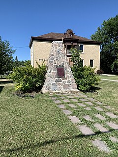
Grand Coulee is a town in the Canadian province of Saskatchewan. It is located 18 km (11 mi) west of downtown Regina. It is home to an annual event called "The Hoe Down".

Division No. 3 is a census division located within the Pembina Valley Region in the south-central region of the province of Manitoba, Canada. Unlike in some other provinces, census divisions do not reflect the organization of local government in Manitoba. These areas exist solely for the purposes of statistical analysis and presentation; they have no government of their own.
Grahamdale is a rural municipality in the province of Manitoba in Western Canada. It was incorporated as a Local Government District (LGD) on 1 January 1945, and became a Rural Municipality in 1997.
Montcalm is a rural municipality (RM) in the province of Manitoba in Western Canada. The Canada 2016 Census reported a population of 1,260 persons, a decrease from the 1,309 reported in the 2011 Census.
The Rural Municipality of Rhineland is a former rural municipality (RM) in the Canadian province of Manitoba. Since 1876, the area made up part of the Mennonite West Reserve. The R.M. of Rhineland was originally incorporated as a rural municipality on February 14, 1880 and later absorbed the neighbouring RM of Douglas in January 1891. It ceased on January 1, 2015 as a result of its provincially mandated amalgamation with the towns of Gretna and Plum Coulee to form the Municipality of Rhineland.
Stanley is a rural municipality (RM) in the province of Manitoba in Western Canada. It is located in the southern part of the province, along its border with the state of North Dakota in the United States. Since 1876, the area made up part of the Mennonite West Reserve. The municipality has a population of 8,969 as of the 2016 Canada Census. The cities of Winkler and Morden lie geographically within the municipality but are separate urban municipalities.
Sunset Beach is a summer village in Alberta, Canada. It is located on the eastern shore of Baptiste Lake.
Ste. Anne is a rural municipality in the Eastman Region of Manitoba, Canada, lying southeast of Winnipeg. The separately-administered town of Ste. Anne lies within the geographic borders of the municipality, in its northwestern part.
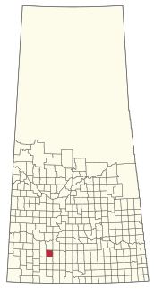
The Rural Municipality of Coulee No. 136 is a rural municipality (RM) in the Canadian province of Saskatchewan within Census Division No. 7 and SARM Division No. 3. The RM is located in the southwest portion of the province, southeast of the City of Swift Current.
The Municipality of Grassland is a rural municipality (RM) in the Canadian province of Manitoba.
The Municipality of Rhineland is a rural municipality (RM) in the Canadian province of Manitoba. The RM had a population of 5,945 as of the 2016 Canada Census. The average age in the municipality is 31.
The Municipality of Souris – Glenwood is a rural municipality (RM) in the Canadian province of Manitoba.

