Homewood | |
|---|---|
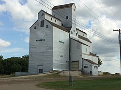 Grain Elevator at Homewood (Demolished in August, 2021) | |
 Homewood Location of Homewood in Manitoba | |
| Coordinates: 49°30′31″N97°51′51″W / 49.50861°N 97.86417°W | |
| Country | |
| Province | |
| Region | Pembina Valley |
| Census Division | No. 3 |
| Government | |
| • Governing Body | Rural Municipality of Dufferin Council |
| • MP | Branden Leslie |
| • MLA | Lauren Stone |
| Time zone | UTC−6 (CST) |
| • Summer (DST) | UTC−5 (CDT) |
| Postal Code | R0G 0Y0 |
| Area code | 204 |
| NTS Map | 062H12 |
| GNBC Code | GALBD |
Homewood is an unincorporated community in south central Manitoba, Canada. It is located approximately 10 kilometers (6 miles) east of Carman, Manitoba [1] in the Rural Municipality of Dufferin. The privately owned and operated Homewood Airport is located near the community.[ citation needed ]
