Division No. 1, Manitoba

Last updated

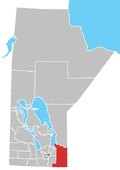
Location of Division 1 in Manitoba Manitoba-census area 01.png
Location of Division 1 in Manitoba

Division No. 1 is a census division located within the Eastman Region of the Canadian province of Manitoba. Unlike in some other provinces, census divisions do not reflect the organization of local government in Manitoba. These areas exist solely for the purposes of statistical analysis and presentation; they have no government of their own.

Contents

It is located in the south-eastern corner of the province, lying between the Lake Winnipeg and Manitoba-Ontario border, and the Canada–US border. The Trans-Canada Highway runs through the Eastman Region. Also included in the division are the Buffalo Point First Nation and the Manitoba portion of the Shoal Lake 40 First Nation.

Subdivisions

Aerial view of Lac du Bonnet RM and Pinawa LGD, with Unorganized Div. 1 in the distant background Lac du Bonnet MB.jpg
Aerial view of Lac du Bonnet RM and Pinawa LGD, with Unorganized Div. 1 in the distant background

Towns

Local government districts

Rural municipalities

First Nations reserves

Unorganized areas

Related Research Articles

Westman Region

The Westman Region is an informal geographic region of the Canadian province of Manitoba located in the southwestern corner of the province.

Lac du Bonnet (electoral district) Provincial electoral district in Manitoba, Canada

Lac du Bonnet is a provincial electoral division in the Canadian province of Manitoba. It was created by redistribution in 1957, and has formally existed since the provincial election of 1958. It is a relatively large constituency, located to the northeast of Winnipeg.

La Verendrye (electoral district) Provincial electoral district in Manitoba, Canada

La Verendrye is a provincial electoral division in the Canadian province of Manitoba. It was created by redistribution in 1879, and has existed since that time.

Northern Manitoba Region of Manitoba, Canada

Northern Manitoba is a geographic and cultural region of the Canadian province of Manitoba. Originally encompassing a small square around the Red River Colony, the province was extended north to the 60th parallel in 1912. The region's specific boundaries vary, as "northern" communities are considered to share certain social and geographic characteristics, regardless of latitude.

Winnipeg Metropolitan Region Metropolitan area in Manitoba, Canada

The Winnipeg Metropolitan Region is a metropolitan area in the Canadian province of Manitoba located in the Red River Valley in the southeast portion of the province of Manitoba, Canada. It contains the provincial capital of Winnipeg and 17 surrounding rural municipalities, cities, and towns.

Pinawa Local government district in Manitoba, Canada

Pinawa is a local government district and small community of 1,331 residents located in southeastern Manitoba, Canada. It is 110 kilometres north-east of Winnipeg. The town is situated on the Canadian Shield within the western boundary of Whiteshell Provincial Park, which lies near the Manitoba-Ontario provincial boundary. Administratively, the town includes the surrounding area, and is officially the Local Government District of Pinawa. Except for a small eastern border with the unorganized area of the Eastman Region, it is surrounded by the Rural Municipalities of Lac du Bonnet to the north and Whitemouth to the south, but is independent of either one. The community lies on the north bank of the Winnipeg River in the southeastern part of the Local Government District.

Parkland Region

Parkland is an informal geographic region of the Canadian province of Manitoba, located between Lakes Manitoba and Winnipegosis on the east and the Manitoba–Saskatchewan border on the west.

Eastman Region

Eastern Manitoba, or the Eastman Region, is an informal geographic region of the Canadian province of Manitoba. It is bounded on the north by the Winnipeg River and Lake Winnipeg, on the east by the Manitoba-Ontario border, on the south by the Canada–US border, and on the west by the Red River.

Division No. 19, Manitoba Census division in Manitoba, Canada

Division No. 19, also informally known as North East Manitoba, is a census division within the Province of Manitoba, Canada. Unlike in some other provinces, census divisions do not reflect the organization of local government in Manitoba. These areas exist solely for the purposes of statistical analysis and presentation; they have no government of their own.

Buffalo Point First Nation is an Ojibwa or Saulteaux First Nations located in the southeastern corner of Manitoba, along the shores of Lake of the Woods. It is bordered largely by the unorganized portion of Division No. 1, Manitoba, and also has smaller borders with the Rural Municipality of Piney, as well as the northeast corner of Roseau County, Minnesota.

Division No. 2, Manitoba Census division in Manitoba, Canada

Census Division No. 2 is a census division located within the Eastman Region in the Canadian province of Manitoba. Unlike in some other provinces, census divisions do not reflect the organization of local government in Manitoba. These areas exist solely for the purposes of statistical analysis and presentation; they have no government of their own.

Division No. 4, Manitoba Census division in Manitoba, Canada

Division No. 4 is a census division located within the Pembina Valley Region in the south-central region of the province of Manitoba, Canada. Unlike in some other provinces, census divisions do not reflect the organization of local government in Manitoba. These areas exist solely for the purposes of statistical analysis and presentation; they have no government of their own.

Division No. 23, Manitoba

Census Division No. 23 is a census division located within the Northern Region of the Province of Manitoba, Canada. Unlike in some other provinces, census divisions do not reflect the organization of local government in Manitoba. These areas exist solely for the purposes of statistical analysis and presentation; they have no government of their own.

Division No. 15, Manitoba Census division in Manitoba, Canada

Census Division No. 15 is a census division located within the Westman Region of the province of Manitoba, Canada. Unlike in some other provinces, census divisions do not reflect the organization of local government in Manitoba. These areas exist solely for the purposes of statistical analysis and presentation; they have no government of their own.

Division No. 17, Manitoba Census division in Manitoba, Canada

Census Division No. 17 (Dauphin) is a census division located within the Parklands Region of the province of Manitoba, Canada. Unlike in some other provinces, census divisions do not reflect the organization of local government in Manitoba. These areas exist solely for the purposes of statistical analysis and presentation; they have no government of their own.

Shoal Lake 40 First Nation is an Ojibway or Ontario First Nation reserve located in the Eastman Region of Manitoba and the Kenora District of Ontario. The total registered population in August 2021 was 667, of which the on-reserve population was 295. The First Nation is a member of the Bimose Tribal Council, a Regional Chief's Council that is a member of the Grand Council of Treaty 3.

Division No. 1, Unorganized, or Whiteshell Unorganized, is a Statistics Canada census subdivision of its Division No. 1, Manitoba that consists of a part of the division that is not organized into either incorporated municipalities or Indian reserves. Unlike in some other provinces, census divisions do not reflect the organization of local government in Manitoba. However, unorganized subdivisions are treated as county-equivalents by county collectors like Manitoba's rural municipalities.

Shoal Lake 39 First Nation is an Ojibwa or Anishinaabe First Nation, located along the northwestern shores of Shoal Lake, Ontario. It is officially known as Iskatewizaagegan #39 Independent First Nation. The total registered population of this First Nation is 585, of which 297 live on its own reserves. They are governed by a chief and council, with their current Chief Gerald Lewis having been elected in March 2016 for a two-year term.

References

Coordinates: 49°53′N95°58′W / 49.883°N 95.967°W / 49.883; -95.967