Roseau River Anishinabe First Nation is a First Nation in southern Manitoba, Canada.
The Rural Municipality of Alexander is a rural municipality in the Eastern region of Manitoba, Canada. The office is located in St. Georges, Manitoba. The town of Powerview-Pine Falls lies adjacent to the municipality, as does the Sagkeeng First Nation Indian reserve. The Chevrefils District and Broadlands are located in the R.M.
Hadashville is a small community in eastern Manitoba, Canada. It is located about 100 kilometres east of Winnipeg on Highway 11, 2 miles north of the Trans-Canada Highway. Hadashville is located in the Whitemouth River watershed north of the Sandilands Provincial Forest. Administratively, it is part of the Rural Municipality of Reynolds. It has sandy soil, many farms, and is surrounded by the boreal forest. This Whitemouth River area is very close to the western edge of the Canadian Shield, and just north of the United States border.

CHVN-FM is a radio station licensed to Winnipeg, Manitoba, broadcasting a contemporary Christian music format. It first began broadcasting in 2000. The station is currently owned by Golden West Broadcasting.

Sobětuchy is a village in Pardubice Region of the Czech Republic. It has around 600 inhabitants.
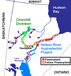
The Nelson River Hydroelectric Project refers to the construction of a series of dams and hydroelectric power plants on the Nelson River in Northern Manitoba, Canada. The project began to take shape in the late 1950s, with the planning and construction of the Kelsey dam and hydroelectric power station, and later was expanded to include the diversion of the upper Churchill River into the Nelson River and the transformation of Lake Winnipeg, the world's 11th largest freshwater lake, into a hydroelectric reservoir. The project is owned and operated by Manitoba Hydro, the electrical utility in the province.
The Rural Municipality of Richot is a rural municipality bordering the south side of Winnipeg in Manitoba, Canada. It is part of the Winnipeg Capital Region and it had a population of 6,679 as of the 2016 census. The separately administered town of Niverville lies adjacent to its southeastern part, between it and the Rural Municipality of Hanover. The municipality seat is located in St. Adolphe.

Piney is a community in southeastern Manitoba, Canada, in the Rural Municipality of Piney. It is approximately 130 kilometers from Winnipeg and within five kilometres of the Canada–US border. In 2016 its population was 1726.
KVXR is a radio station located in Moorhead, MN airing Catholic programming the Real Presence Radio, including programming from the national EWTN Radio network. KVXR is owned by Real Presence Radio of Grand Forks, North Dakota
Vesitükimaa is a small, uninhabited Estonian islet located in Torgu Parish, at the tip of Sõrve Peninsula of Saaremaa island. It is a site of European Community importance for the Boreal biogeographical region, its coordinates are 57°53′49″N22°02′26″E and its territory is 12,6 km2.

Division No. 1 is located in the Eastman Region of the Canadian province of Manitoba. It is located in the south-eastern corner of the province, lying between the Lake Winnipeg and Manitoba-Ontario border, and the Canada–US border. The Trans-Canada Highway runs through the Eastman Region. Also included in the division are the Buffalo Point First Nation and the Manitoba portion of the Shoal Lake 40 First Nation.
Sprague is a community in the Canadian province of Manitoba minutes from Minnesota and Ontario. It is located in the Rural Municipality of Piney, about one hour southeast of Steinbach and 1.5 hours southeast of Winnipeg. It is a small town located at the junctions of Manitoba Highway 12 and Provincial Road 308. The nearest major centres include Warroad, Fort Frances, Steinbach, and Thief River Falls.
Hillside Beach is a summer resort located on the eastern shore of Lake Winnipeg in the Canadian province of Manitoba in the Rural Municipality of Alexander. It is approximately 95 kilometres from Winnipeg, Manitoba. Hillside Beach has a two-kilometre sand beach and dunes in a protected bay of Lake Winnipeg, just across from Victoria Beach. The protected bay offers conditions for sailing, surfing, water skiing and fishing. A three-kilometre wide lagoon is located behind the dunes, which is used for fishing, canoeing and birdwatching. Facilities at Hillside Beach include a general store and cafe, a gas station, a realty office and a utility rental shop.

Makowica is a village in the administrative district of Gmina Limanowa, within Limanowa County, Lesser Poland Voivodeship, in southern Poland. It lies approximately 8 kilometres (5 mi) north of Limanowa and 47 km (29 mi) south-east of the regional capital Kraków.
Barycz is a village in the administrative district of Gmina Domaradz, within Brzozów County, Subcarpathian Voivodeship, in south-eastern Poland. It lies approximately 14 kilometres (9 mi) north of Brzozów and 25 km (16 mi) south of the regional capital Rzeszów.
Pełki is a settlement in the administrative district of Gmina Dziemiany, within Kościerzyna County, Pomeranian Voivodeship, in northern Poland. It lies approximately 7 kilometres (4 mi) north-west of Dziemiany, 22 km (14 mi) south-west of Kościerzyna, and 72 km (45 mi) south-west of the regional capital Gdańsk.
Jackowo is a village in the administrative district of Gmina Choczewo, within Wejherowo County, Pomeranian Voivodeship, in northern Poland. It lies approximately 5 kilometres (3 mi) north-west of Choczewo, 33 km (21 mi) north-west of Wejherowo, and 69 km (43 mi) north-west of the regional capital Gdańsk.
Třebětín is a village and municipality in Kutná Hora District in the Central Bohemian Region of the Czech Republic.
Wyandale, New York is a small, hamlet in the town of Concord in southern Erie County, New York, United States.
Christopher Fork is an unincorporated community in Caroline County, in the U.S. state of Virginia.


