Seven Sisters Falls, Manitoba

Last updated

Seven Sisters Falls
Canada Manitoba location map 2.svg
Red pog.svg
Seven Sisters Falls
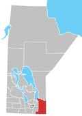
Location of Whitemouth in Manitoba
Coordinates: 50°06′19″N96°00′54″W / 50.10528°N 96.01500°W / 50.10528; -96.01500
Country Canada
Province Manitoba
Region Eastman
Rural Municipality Whitemouth
Established1929
Government
   MP (Provencher) Ted Falk (CPC)
   MLA (Lac du Bonnet) Wayne Ewasko
Elevation
268 m (879 ft)
Population
  Total180 [1]
 estimated
Time zone UTC-6 (CST)
  Summer (DST) UTC-5 (CDT)
Website rmwhitemouth.com

Seven Sisters Falls is a community in the Rural Municipality of Whitemouth, Manitoba. [2]

It is the location of Manitoba Hydro's Seven Sisters Generating Station and the Whitemouth Falls Provincial Park. Seven Sisters Falls was named by fur traders for a series of seven rapids that were located along the Winnipeg River which are now the site of the hydroelectric dam. [3]

Related Research Articles

<span class="mw-page-title-main">Winnipeg River</span> River in the Canadian provinces of Manitoba and Ontario

The Winnipeg River is a Canadian river that flows roughly northwest from Lake of the Woods in the province of Ontario to Lake Winnipeg in Manitoba. This river is 235 kilometres (146 mi) long from the Norman Dam in Kenora to its mouth at Lake Winnipeg. Its watershed is 106,500 square kilometres (41,100 sq mi) in area, mainly in Canada. About 29,000 square kilometres (11,000 sq mi) of the watershed is in northern Minnesota, United States.

Provincial Trunk Highway 11 is a provincial primary highway located in the Eastman Region of the Canadian province of Manitoba. It runs from an intersection with PTH 59 near Victoria Beach to an intersection with PTH 1.

<span class="mw-page-title-main">Eastman Region</span> Region in Manitoba, Canada

Eastern Manitoba, or the Eastman Region, is an informal geographic region of the Canadian province of Manitoba. It is bounded on the north by the Winnipeg River and Lake Winnipeg, on the east by the Manitoba-Ontario border, on the south by the Canada–US border, and on the west by the Red River. With a population of 128,855 as of the 2021 Canadian census, the Eastman Region is the second most populous region outside of the Winnipeg Metropolitan Region.

Hadashville is a small, unincorporated community in the Rural Municipality of Reynolds, in eastern Manitoba, Canada.

<span class="mw-page-title-main">Whitemouth River</span> River in Manitoba, Canada

The Whitemouth River is located in southeastern Manitoba, Canada. The mouth of the river empties into the Winnipeg River system at the Whitemouth Falls Provincial Park.

<span class="mw-page-title-main">Whitemouth, Manitoba</span> Place in Manitoba, Canada

Whitemouth is a community in the Rural Municipality of Whitemouth, located in southeastern Manitoba, Canada. The community is named after the Whitemouth River. It was established in 1905 along the main Canadian Pacific Railway line.

<span class="mw-page-title-main">Elma, Manitoba</span> Place in Manitoba, Canada

Elma, Manitoba, is an unincorporated community of approximately 100 people in southeast Manitoba. It is located on the Whitemouth River, at the junction of Highway 15 and Highway 11 in the Rural Municipality of Whitemouth.

Provincial Trunk Highway 44 is an east-west provincial highway in the Eastman Region of the Canadian province of Manitoba.

<span class="mw-page-title-main">Division No. 1, Manitoba</span> Census division in Manitoba, Canada

Division No. 1 is a census division located within the Eastman Region of the Canadian province of Manitoba. Unlike in some other provinces, census divisions do not reflect the organization of local government in Manitoba. These areas exist solely for the purposes of statistical analysis and presentation; they have no government of their own.

Prawda is an unincorporated community in the Rural Municipality of Reynolds, situated a few miles east of Hadashville on the Trans Canada Highway in eastern Manitoba. The population of this community is 200. The community's amenities include two service stations/convenience store & restaurants, a Tesla Supercharger, and a campground (Pinetree).

Dr. Charlotte Whitehead (Ross) was a physician important to Canadian history and Manitoban history for her role as a pioneer for women in medicine, particularly in Manitoba. Despite never being licensed by either the College of Physicians and Surgeons of Quebec or Manitoba, she was nonetheless able to practice medicine in Montreal and Whitemouth for several decades, and served the community in and around Whitemouth to a great degree during the early years of its development.

<span class="mw-page-title-main">Rural Municipality of Whitemouth</span> Rural municipality in Manitoba, Canada

The Rural Municipality of Whitemouth is a rural municipality (RM) located in southeastern Manitoba.

<span class="mw-page-title-main">Whitemouth Falls Provincial Park</span> Provincial park in Manitoba, Canada

Whitemouth Falls Provincial Park is a provincial park located where the Whitemouth River joins the Winnipeg River in Manitoba, Canada. It was designated as a Provincial Park in 1974.

Whitemouth Bog Ecological Reserve is an ecological reserve located southwest of Whiteshell Provincial Park, Manitoba, Canada. It was established in 2009 under the Manitoba Ecological Reserves Act, and protects a tract of rich peatland bog in southeastern Manitoba.

Whitemouth Island Ecological Reserve is an ecological reserve which is the largest island of Whitemouth Lake in Manitoba. It was established in 1999 under the Manitoba Ecological Reserves Act. It is 6.13 square kilometres (2.37 sq mi) in size. The island is the most western example of a largely undisturbed deciduous forest of the St. Lawrence - Great Lakes region in Canada. It contains eight examples of eastern deciduous plants that are considered rare in Manitoba such as Dutchman's Breeches, green adder's mouth, blue cohosh, New Jersey tea, and enchanter's nightshade.

Whitemouth River Ecological Reserve is an ecological reserve located within the Sandilands Provincial Forest, Manitoba, Canada. It was established in 1986 under the Manitoba Ecological Reserves Act. It is 1.3 square kilometres (0.50 sq mi) in size.

Whitemouth Bog Wildlife Management Area is a wildlife management area that lies on either side of the Whitemouth Bog Ecological Reserve, Manitoba, Canada. It was established in 2009 under the Manitoba Wildlife Act. It is 30.1 square kilometres (11.6 sq mi) in size.

<span class="mw-page-title-main">Manitoba Provincial Road 307</span>

Provincial Road 307 is a provincial road in the eastern part of the Canadian province of Manitoba. It is part of the La Vérendrye Trail in eastern Manitoba and lies mostly within Whiteshell Provincial Park.

References

  1. "Seven Sisters Falls". Eastman Tourism. Retrieved December 17, 2020.
  2. "Seven Sisters Falls". Geographical Names Search. Natural Resources Canada. Retrieved November 27, 2016.
  3. "Small Town Spotlight: Seven Sisters Falls". Travel Manitoba - Facebook. March 24, 2017.