Prawda, Manitoba

Last updated

Prawda
Unincorporated community
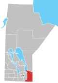
Canada Manitoba location map 2.svg
Red pog.svg
Prawda
Coordinates: 49°39′03″N95°47′37″W / 49.65083°N 95.79361°W / 49.65083; -95.79361
CountryFlag of Canada (Pantone).svg  Canada
ProvinceFlag of Manitoba.svg  Manitoba
Municipality RM of Reynolds
First settled1907
Population
  Total200
Area code(s) 204

Prawda is an unincorporated community in the Rural Municipality of Reynolds, situated a few miles east of Hadashville on the Trans Canada Highway in eastern Manitoba. The population of this community is 200. The community's amenities include two service stations/convenience store & restaurants (Birchwood Esso and Prawda Shell), a Tesla Supercharger, and a campground (Pinetree). [1]

The area was settled by Ukrainian, Polish, and Russian settlers starting about 1907. By 1932, there was a post office opened which operated until 1969. The community's name comes from the Polish word prawda , which means 'truth'. [2] The name may have come from Evangeline Andrusko, the postmistress who named the post office after a town of the same name in her native Poland. [2] The name has also been attributed to a local school named by Harry Paskaryk.

A school district was part of the community with the school located on section NE 31-2-6E. The present-day school is Reynolds Elementary School and serves K to 6, after which the students are bussed to Whitemouth, Manitoba. The area is agricultural and has ties to the forestry industry. Prawda is also home to a livestock feed store (Trails End Livestock), satellite services (Bert's Satellite), plumber (Kuharski Bros.), nurseries (Bilan Tree Nursery, NJ Enterprises, Pips River Nursery), and a community club (Reynolds Community Club). Residents travel to Whitemouth, Ste. Anne, Steinbach, or Winnipeg for medical needs. Reynolds Fire Department, built in 2005, is located at Prawda. The telephone area code for Prawda is 204.

Related Research Articles

<span class="mw-page-title-main">Charleswood, Winnipeg</span> Suburb of Winnipeg

Charleswood is a residential community and neighbourhood in Winnipeg, Manitoba, Canada. It is located in the South-West of the city and is bordered by the neighbourhoods Tuxedo to the East, Fort Whyte to the South, and the Rural Municipality of Headingley on the West. It's boundaries are Roblin and the Assiniboine River to the north, Shaftesbury Boulevard on the East, Wilkes Avenue to the South and the Perimeter Highway to the West.

<span class="mw-page-title-main">Pinawa</span> Local government district in Manitoba, Canada

Pinawa is a local government district and small community of 1,331 residents located in southeastern Manitoba, Canada. It is 110 kilometres north-east of Winnipeg. The town is situated on the Canadian Shield within the western boundary of Whiteshell Provincial Park, which lies near the Manitoba-Ontario provincial boundary. Administratively, the town includes the surrounding area, and is officially the Local Government District of Pinawa. Except for a small eastern border with the unorganized area of the Eastman Region, it is surrounded by the Rural Municipalities of Lac du Bonnet to the north and Whitemouth to the south, but is independent of either one. The community lies on the north bank of the Winnipeg River in the southeastern part of the Local Government District.

<span class="mw-page-title-main">Rural Municipality of Headingley</span> Rural municipality in Manitoba, Canada

Headingley is a rural municipality in Manitoba, Canada. It is located directly west of Winnipeg and had a population of 3,579 people as of the 2016 census.

East Selkirk is a community of 675 in the Rural Municipality (RM) of St. Clements in the Canadian province of Manitoba. It is directly across the Red River from Selkirk, Manitoba.

Hadashville is a small, unincorporated community in the Rural Municipality of Reynolds, in eastern Manitoba, Canada.

<span class="mw-page-title-main">Rural Municipality of Reynolds</span> Rural municipality in Manitoba, Canada

The Rural Municipality of Reynolds is a rural municipality (RM) in southeastern Manitoba, Canada.

<span class="mw-page-title-main">Russell, Manitoba</span> Unincorporated urban community in Manitoba, Canada

Russell is an unincorporated urban community in the Municipality of Russell – Binscarth, Manitoba.

Badger, Manitoba is a hamlet in the Rural Municipality of Piney, Manitoba. The community, whose elevation is 377 m (1,236 ft), lies southwest of Whitemouth Lake, and is surrounded by the Sandilands Provincial Forest.

<span class="mw-page-title-main">Elma, Manitoba</span> Place in Manitoba, Canada

Elma, Manitoba, is an unincorporated community of approximately 100 people in southeast Manitoba. It is located on the Whitemouth River, at the junction of Highway 15 and Highway 11 in the Rural Municipality of Whitemouth.

<span class="mw-page-title-main">St. Adolphe, Manitoba</span> Place in Manitoba, Canada

St. Adolphe, or Saint Adolphe, originally called Pointe-Coupée, is a community in the Rural Municipality of Ritchot, Manitoba, Canada. It is located along the east bank of the Red River, approximately 12 kilometres south of Winnipeg.

<span class="mw-page-title-main">Warren, Manitoba</span> Unincorporated Community in Manitoba, Canada

Warren is an unincorporated community recognized as a local urban district 26.3 kilometres north-west of Winnipeg, Manitoba. It is located in the Rural Municipality of Woodlands.

Minitonas is an unincorporated urban community in the Municipality of Minitonas – Bowsman, Manitoba, Canada. It is surrounded by the Swan Valley and is located 15 km east of the Town of Swan River. The community is close to the Duck Mountain Provincial Park.

<span class="mw-page-title-main">Anola</span> Place in Manitoba, Canada

Anola is an unincorporated community in the Canadian province of Manitoba. It is located 24 kilometres east of Winnipeg and 40 kilometres north of Steinbach in the Rural Municipality of Springfield. The community has a population of approximately 200 people.

<span class="mw-page-title-main">Rural Municipality of Victoria Beach</span> Rural municipality in Manitoba, Canada

Victoria Beach is a rural municipality (RM) in the Eastman Region of Manitoba, Canada, located on the southeastern shores of Lake Winnipeg, approximately 100 kilometres (62 mi) north of Winnipeg.

<span class="mw-page-title-main">Rural Municipality of Ste. Anne</span> Rural municipality in Manitoba, Canada

Ste. Anne is a rural municipality (RM) in the Eastman Region of Manitoba, Canada, lying southeast of Winnipeg. The separately-administered town of Ste. Anne lies within the geographic borders of the municipality, in its northwestern part.

Plumas is an unincorporated community recognized as a local urban district located in the Municipality of WestLake – Gladstone, in the Canadian province of Manitoba. Plumas is roughly 70 km northwest of Portage la Prairie, Manitoba, and about 150 km northwest of the provincial capital, Winnipeg.

Alexander, Manitoba, is a local urban district in the Rural Municipality of Whitehead, situated on Highway 1, west of Brandon.

<span class="mw-page-title-main">Rural Municipality of Whitemouth</span> Rural municipality in Manitoba, Canada

The Rural Municipality of Whitemouth is a rural municipality (RM) located in southeastern Manitoba.

Ste. Rita is an unincorporated community in the Rural Municipality of Reynolds, Manitoba, located on Manitoba Highway 15 and east of Winnipeg.

The D Division is the division of the Royal Canadian Mounted Police responsible for federal policing in Manitoba and, at times, northwestern Ontario. Headquartered in Winnipeg, the division is commanded by Assistant Commissioner Rob Hill and consists of 1089 police officers and 438 support staff.

References

  1. "RM of Reynolds - Prawda". www.rmofreynolds.com. Retrieved August 8, 2021.
  2. 1 2 "RM of Reynolds - History". www.rmofreynolds.com. Retrieved August 8, 2021.