Rural Municipality of Lac du Bonnet

Last updated

Lac Du Bonnet
Rural municipality
Rural Municipality of Lac Du Bonnet
Lac du Bonnet MB.jpg
Aerial view of RM Lac du Bonnet
CAN MB Lac du Bonnet.svg
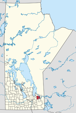
Location of the Rural Municipality of Lac du Bonnet in Manitoba
Coordinates: 50°14′18″N96°04′32″W / 50.23833°N 96.07556°W / 50.23833; -96.07556
CountryCanada
Province Manitoba
Region Eastman
Census division 1
Incorporated1917
Government
   Reeve Loren Schinkel
Area
  Land1,097.61 km2 (423.79 sq mi)
Population
 (2021) [1]
  Total3,563
  Density2.8/km2 (7/sq mi)
Website rmoflacdubonnet.com

Lac du Bonnet is a rural municipality in the province of Manitoba in Western Canada, situated between the Nopiming Provincial Park to the northeast and Whiteshell Provincial Park to the southeast.

Contents

The separately-administered town of Lac du Bonnet lies within the borders of the municipality. It also mostly encircles the Pinawa local government district in the municipality's southeast part. A large portion of the municipality includes waters of the Winnipeg River and its tributaries. [2]

The RM contains the southern part of Manitoba's Brightstone Sand Hills Provincial Forest and the northern part of Agassiz Provincial Forest, although most of these forests lie in other RMs.

Communities

Demographics

In the 2021 Census of Population conducted by Statistics Canada, Lac du Bonnet had a population of 3,563 living in 1,459 of its 2,757 total private dwellings, a change of

See also

Related Research Articles

<span class="mw-page-title-main">Rural Municipality of Rosser</span> Rural municipality in Manitoba, Canada

Rosser is a rural municipality (RM) in the Canadian province of Manitoba, lying adjacent to the northwest side of Winnipeg and part of the Winnipeg Metro Region. Its population as of the 2016 Census was 1,372.

<span class="mw-page-title-main">Rural Municipality of Alexander</span> Rural municipality in Manitoba, Canada

The Rural Municipality of Alexander is a rural municipality in the Eastman Region of Manitoba, Canada. The town of Powerview-Pine Falls lies adjacent to the municipality, as does the Sagkeeng First Nation Indian reserve.

<span class="mw-page-title-main">Rural Municipality of St. Clements</span> Rural municipality in Manitoba, Canada

St. Clements is a rural municipality (RM) in Manitoba, Canada. It is located to the north-east of Winnipeg, stretching from East St. Paul and Birds Hill Provincial Park in the south to Lake Winnipeg and Grand Beach Provincial Park to the north. The Red River demarcates the western boundary of the municipality. St. Clements contains the communities of East Selkirk, and Lockport east of the Red River. It almost completely surrounds the Brokenhead 4 Indian reserve, with the exception of a small lakefront on Lake Winnipeg.

<span class="mw-page-title-main">Rural Municipality of Reynolds</span> Rural municipality in Manitoba, Canada

The Rural Municipality of Reynolds is a rural municipality (RM) in southeastern Manitoba, Canada.

<span class="mw-page-title-main">Rural Municipality of Springfield</span> Rural municipality in Manitoba, Canada

Springfield is a rural municipality (RM) in Manitoba, Canada. It stretches from urban industrial development on the eastern boundary of the city of Winnipeg, through urban, rural residential, agricultural and natural landscapes, to the Agassiz Provincial Forest on the municipality's eastern boundary. Birds Hill Provincial Park nestles into the north-western corner of Springfield.

<span class="mw-page-title-main">Lac du Bonnet, Manitoba</span> Town in Manitoba, Canada

Lac du Bonnet is a town in Manitoba, Canada located 115 km (71 mi) northeast of Winnipeg on the west shore of the Winnipeg River. It is surrounded by the Rural Municipality of Lac du Bonnet. The word "Bonnet" is pronounced by locals as "bonny."

<span class="mw-page-title-main">Rural Municipality of Victoria</span> Rural municipality in Manitoba, Canada

The Rural Municipality of Victoria is a rural municipality (RM) located in south-central Manitoba, north-east of Glenboro. The RM was established in 1902 and named for Queen Victoria. In its westernmost part, the RM contains parts of Manitoba's Spruce Woods Provincial Forest and Spruce Woods Provincial Park.

<span class="mw-page-title-main">Rural Municipality of De Salaberry</span> Rural municipality in Manitoba, Canada

De Salaberry is a rural municipality in the province of Manitoba in western Canada. The administratively separate village of St-Pierre-Jolys and St. Malo Provincial Park lie within the geographical borders of the municipality. The municipality is named after Charles de Salaberry.

<span class="mw-page-title-main">Rural Municipality of Stanley</span> Rural municipality in Manitoba, Canada

Stanley is a rural municipality (RM) in the province of Manitoba in Western Canada. It is located in the southern part of the province, along its border with the state of North Dakota in the United States. Since 1876, the area made up part of the Mennonite West Reserve. The municipality has a population of 8,969 as of the 2016 Canada Census. The cities of Winkler and Morden lie geographically within the municipality but are separate urban municipalities.

<span class="mw-page-title-main">Rural Municipality of Alonsa</span> Rural municipality in Manitoba, Canada

Alonsa is a rural municipality (RM) in the province of Manitoba, western Canada. It lies on the west side of Lake Manitoba.

<span class="mw-page-title-main">Rural Municipality of Mountain</span> Rural municipality in Manitoba, Canada

The Rural Municipality of Mountain is a rural municipality (RM) in the Parkland Region of Manitoba, western Canada.

<span class="mw-page-title-main">Rural Municipality of Ste. Anne</span> Rural municipality in Manitoba, Canada

Ste. Anne is a rural municipality (RM) in the Eastman Region of Manitoba, Canada, lying southeast of Winnipeg. The separately-administered town of Ste. Anne lies within the geographic borders of the municipality, in its northwestern part.

<span class="mw-page-title-main">Rural Municipality of Stuartburn</span> Rural municipality in Manitoba, Canada

Stuartburn is a rural municipality (RM) located in the Eastman Region of Manitoba, Canada. It had a population of 1,629 according to the Canada 2006 Census.

Division No. 1, Unorganized, or Whiteshell Unorganized, is a Statistics Canada census subdivision of its Division No. 1, Manitoba that consists of a part of the division that is not organized into either incorporated municipalities or Indian reserves. Unlike in some other provinces, census divisions do not reflect the organization of local government in Manitoba.

<span class="mw-page-title-main">Rural Municipality of Whitemouth</span> Rural municipality in Manitoba, Canada

The Rural Municipality of Whitemouth is a rural municipality (RM) located in southeastern Manitoba.

<span class="mw-page-title-main">Municipality of Glenboro-South Cypress</span> Rural municipality in Manitoba, Canada

The Municipality of Glenboro – South Cypress is a rural municipality (RM) in the Canadian province of Manitoba.

<span class="mw-page-title-main">Rural Municipality of Lakeshore</span> Rural municipality in Manitoba, Canada

The Rural Municipality of Lakeshore is a rural municipality (RM) in the Parkland Region of Manitoba, Canada.

<span class="mw-page-title-main">Municipality of Ste. Rose</span> Rural municipality in Manitoba, Canada

The Municipality of Ste. Rose is a rural municipality (RM) in the Canadian province of Manitoba.

References

  1. 1 2 "Population and dwelling counts: Canada, provinces and territories, and census subdivisions (municipalities), Manitoba". Statistics Canada. February 9, 2022. Retrieved February 20, 2022.
  2. "History of the Rural Municipality of Lac du Bonnet". www.rmoflacdubonnet.com. Retrieved August 7, 2021.